
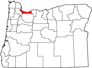
Clark County is the southernmost county in the U.S. state of Washington. As of the 2020 census, the population was 503,311, making it Washington's fifth-most populous county. Its county seat and largest city is Vancouver. It was the first county in Washington, first named Vancouver County in 1845 before being renamed for William Clark of the Lewis and Clark Expedition in 1849. It was created by the Provisional Government of Oregon in Oregon Country on August 20, 1845, and at that time covered the entire present-day state. Clark County is the third-most-populous county in the Portland-Vancouver-Hillsboro Metropolitan Statistical Area, and is across the Columbia River from Portland, Oregon.

Erie County is a county along the shore of Lake Erie in western New York State. As of the 2020 census, the population was 954,236. The county seat is Buffalo, which makes up about 28% of the county's population. Both the county and Lake Erie were named for the regional Iroquoian language-speaking Erie tribe of Native Americans, who lived in the area before 1654. They were later pushed out by the more powerful Iroquoian nations tribes.

Forest Grove is a city in Washington County, Oregon, United States, 25 miles (40 km) west of Portland. Originally a small farm town, it is now primarily a commuter town in the Portland metro area. Settled in the 1840s, the town was platted in 1850, then incorporated in 1872, making it the first city in Washington County. The population was 21,083 at the 2010 census, an increase of 19.1% over the 2000 figure (17,708).

Multnomah Falls is a waterfall located on Multnomah Creek in the Columbia River Gorge, east of Troutdale, between Corbett and Dodson, Oregon, United States. The waterfall is accessible from the Historic Columbia River Highway and Interstate 84. Spanning two tiers on basalt cliffs, it is the tallest waterfall in the state of Oregon at 620 ft (189 m) in height. The Multnomah Creek Bridge, built in 1914, crosses below the falls, and is listed on the National Register of Historic Places.

The Lewis and Clark National Historical Park, located in the vicinity of the mouth of the Columbia River, commemorates the Lewis and Clark Expedition. Administration of the park, which includes both federal and state lands, is a cooperative effort of the National Park Service and the states of Oregon and Washington. The National Historical Park was dedicated on November 12, 2004.
Orenco is a former company town in Washington County, Oregon, United States, located between Hillsboro and Aloha. The former community of Orenco now forms the Orenco neighborhood in Hillsboro, which is the site of the Orenco Station housing development.
The Allentown district is a neighborhood in Buffalo, New York. The neighborhood is home to the Allentown Historic District.
The Northwest District is a densely populated retail and residential neighborhood in the northwest section of Portland, Oregon, United States. Craftsman-style and Old Portland-style houses are packed tightly together with old apartment buildings and new condominiums, within walking distance of restaurants, bars, and shops. The Portland Streetcar's first line terminates there, connecting the district to the Pearl District, Downtown Portland and points south to the South Waterfront, and several TriMet bus lines also serve the district.
The following list presents the full set of National Register of Historic Places listings in Multnomah County, Oregon. However, please see separate articles for listings in each of Portland's six quadrants.

Silver Falls State Park is a state park in the U.S. state of Oregon, located near Silverton, about 20 miles (32 km) east-southeast of Salem. It is the largest state park in Oregon with an area of more than 9,000 acres (36 km2), and it includes more than 24 miles (39 km) of walking trails, 14 miles (23 km) of horse trails, and a 4-mile (6.4 km) bike path. Its 8.7-mile (14.0 km) Canyon Trail/Trail of Ten Falls runs along the banks of Silver Creek and by ten waterfalls, from which the park received its name. Four of the ten falls have an amphitheater-like surrounding that allows the trail to pass behind the flow of the falls. The Silver Falls State Park Concession Building Area and the Silver Creek Youth Camp-Silver Falls State Park are separately listed on the U.S. National Register of Historic Places.

Tippecanoe Township is one of thirteen townships in Tippecanoe County, Indiana, United States. As of the 2010 census, its population was 7,702 and it contained 3,085 housing units.
Tualatin Academy was a secondary school in the U.S. state of Oregon that eventually became Pacific University. Tualatin Academy also refers to the National Register of Historic Places-listed college building constructed in 1850 to house the academy, also known as Old College Hall. The building now serves as the Pacific University Museum, and is one of the oldest collegiate buildings in the western United States.

Forest Park Southeast (FPSE) is a neighborhood of St. Louis, Missouri. It is bordered by Interstate 64 (U.S. Route 40) to the north, Vandeventer Avenue to the east, Interstate 44 to the south, and Kingshighway Boulevard and Forest Park to the west. Adjoining neighborhoods include Kings Oak and The Hill to the west, Southwest Garden to the south, Botanical Heights to the southeast, Midtown to the east, and the Central West End to the north.
The East Portland Grand Avenue Historic District, located in southeast Portland, Oregon, is listed on the National Register of Historic Places. The district includes approximately 20 city blocks on or near Southeast Grand Avenue on the east side of the Willamette River, roughly bounded on the south by SE Main Street, north by SE Ankeny Street, west by SE Martin Luther King Jr. Boulevard, and east by SE Seventh Avenue. Most structures in the district are commercial buildings rising two to three stories. Immediately to the west of the historic district is Portland's east side industrial area, and to the east are industrial and residential areas.
The Walker Naylor Historic District, also referred to as Walker's and Naylor's Additions Historic District, located in Forest Grove, Oregon, is listed on the National Register of Historic Places (NRHP). The district is bounded by Gayles Way on the west, Covey Run Drive on the north, A Street on the east, and 21st Avenue on the south, which is west of Pacific University and north of the city's downtown area. Walker Naylor was added to the NRHP in 2011, the third historic district in Forest Grove. The district has 145 properties covering 32 acres (13 ha), and includes three houses listed on the National Register.
The Painter's Woods Historic District, located in Forest Grove, Oregon, is listed on the National Register of Historic Places. Painter's Woods includes the earliest modern subdivision addition to Forest Grove, and represents Forest Grove's transition from a largely agrarian community to a small-urban center of commerce and education. Subsequent construction reflected the ebbs and flows of development in Forest Grove over time. Primarily residential in character, the district includes well-preserved examples of a broad range of architectural styles in currency between 1880 and 1948. It is adjacent to the Clark Historic District.

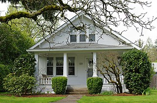
The Benjamin Cornelius Jr. House, also known as the Benjamin Cornelius Jr. and Rachel McKinney Cornelius House, is a historic residence located in Forest Grove, Oregon, United States. It was built around 1873 by carpenter Harley McDonald, one of the first settlers to offer architectural services in Oregon, and is one of only two houses designed by McDonald remaining in Forest Grove. Its Italianate form and Gothic details are highly distinctive in Forest Grove, while its veranda exhibits Colonial styling. Benjamin and Rachel Cornelius, the first occupants of the house, had crossed the Oregon Trail via the Meek Cutoff in 1845; the Cornelius family was instrumental in the foundation of Hillsboro and the town of Cornelius during their lifetime, and Benjamin was also prominently involved in early real estate transactions in the area. Benjamin was murdered in 1881, during the couple's tenure at this house.

