Coalville, Iowa

Last updated

Coalville, Iowa
CDP
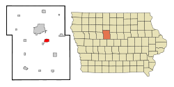
Webster County Iowa Incorporated and Unincorporated areas Coalville Highlighted.svg
Location of Coalville, Iowa
Coordinates: 42°26′37″N94°7′43″W / 42.44361°N 94.12861°W / 42.44361; -94.12861
Country Flag of the United States (23px).png  United States
State Flag of Iowa.svg  Iowa
County Webster
Area
[1]
  Total2.26 sq mi (5.85 km2)
  Land2.18 sq mi (5.65 km2)
  Water0.07 sq mi (0.19 km2)
Elevation
1,115 ft (340 m)
Population
 (2020)
  Total651
  Density298.21/sq mi (115.15/km2)
Time zone UTC-6 (Central (CST))
  Summer (DST) UTC-5 (CDT)
ZIP code
50501
Area code 515
FIPS code 19-14835
GNIS feature ID0455503

Coalville is a census-designated place (CDP) in Webster County, Iowa, United States. The population was 651 at the 2020 census. The community is located on U.S. Route 20 near Fort Dodge's large gypsum mines.

Contents

History

Map of the Coalville area from 1908, showing the railroads and coal mines (shown in red) of the region. Coalville is in the upper left quadrant. CoalvilleMines.png
Map of the Coalville area from 1908, showing the railroads and coal mines (shown in red) of the region. Coalville is in the upper left quadrant.

Coalville takes its name from the coal mines of the area. It began as one of the northernmost coal mining towns in Iowa. Early settlers were mining coal from outcrops along the Des Moines River by 1860, and in 1870, a mine was opened on Holiday Creek, approximately one mile east of Coalville, with a three-mile tramway to the Dubuque and Sioux City Railroad (later the Illinois Central). Later in 1870, a shaft was sunk at Coalville. The Fort Dodge Coal company took over these mines and opened several more in the Coalville area. By 1880, manual labor was being augmented with machinery in these mines. In 1883, the Fort Dodge Coal company employed 350 miners to produce 30 carloads of coal daily.

The Pleasant Valley Coal Company sank a 105-foot shaft in Coalville in 1895, employing 100 men to mine a six-foot coal bed. This was mined out in the early 20th century. The Gleason Coal Company sank a shaft in 1899 that operated until 1907, producing 200,000 tons of coal over its lifetime. Gleason sank a new shaft in 1908. [2] United Mine Workers local 392 was organized in Coalville in 1899; by 1907, it had 133 members. Mine wages varied from $1.91 to $2.56 per day. [3]

Coalville's population was 26 in 1902. [4] The population was 150 in 1940. [5]

Geography

Coalville is located at 42°26′37″N94°07′43″W / 42.443522°N 94.128558°W / 42.443522; -94.128558 (42.443522, −94.128558). [6] on the west bank of the Des Moines River.

According to the United States Census Bureau, the city has a total area of 2.26 square miles (5.85 km2), of which 2.18 square miles (5.66 km2) of it is land and 0.07 square miles (0.19 km2) is water.

Demographics

Historical population
CensusPop.Note
2010 610
2020 6516.7%
U.S. Decennial Census [7]

2020 census

As of the census of 2020, [8] there were 651 people, 261 households, and 171 families residing in the community. The population density was 298.2 inhabitants per square mile (115.1/km2). There were 299 housing units at an average density of 137.0 per square mile (52.9/km2). The racial makeup of the community was 91.7% White, 1.7% Black or African American, 0.0% Native American, 0.3% Asian, 0.0% Pacific Islander, 1.5% from other races and 4.8% from two or more races. Hispanic or Latino persons of any race comprised 4.5% of the population.

Of the 261 households, 25.7% of which had children under the age of 18 living with them, 52.1% were married couples living together, 7.7% were cohabitating couples, 16.9% had a female householder with no spouse or partner present and 23.4% had a male householder with no spouse or partner present. 34.5% of all households were non-families. 29.1% of all households were made up of individuals, 16.5% had someone living alone who was 65 years old or older.

The median age in the community was 38.2 years. 27.6% of the residents were under the age of 20; 6.0% were between the ages of 20 and 24; 23.8% were from 25 and 44; 25.5% were from 45 and 64; and 17.1% were 65 years of age or older. The gender makeup of the community was 51.6% male and 48.4% female.

2010 census

As of the census [9] of 2010, there were 610 people, 267 households, and 173 families residing in the town. The population density was 279.2 inhabitants per square mile (107.8/km2). There were 289 housing units at an average density of 132.3 per square mile (51.1/km2). The racial makeup of the town was 92.8% White, 1.6% African American, 0.5% Native American, 0.2% Asian, 0.3% from other races, and 4.6% from two or more races. Hispanic or Latino of any race were 3.1% of the population.

There were 267 households, out of which 26.2% had children under the age of 18 living with them, 51.7% were married couples living together, 7.5% had a female householder with no husband present, 5.6% had a male householder with no wife present, and 35.2% were non-families. 29.6% of all households were made up of individuals, and 10.1% had someone living alone who was 65 years of age or older. The average household size was 2.28 and the average family size was 2.79.

In the city, the population was spread out, with 23.6% under the age of 18, 6.2% from 18 to 24, 23.3% from 25 to 44, 32.1% from 45 to 64, and 14.8% who were 65 years of age or older. The median age was 42.6 years. The gender makeup of the city was 50.3% male and 49.7% female.

The median income for a household in the CDP was $43,750, and the median income for a family was $45,096. Males had a median income of $33,846 versus $20,855 for females. The per capita income for the CDP was $17,178. None of the families and 2.6% of the population were living below the poverty line, including no under eighteens and 17.8% of those over 64.
Education

The Fort Dodge Community School District operates the schools serving the CDP. Butler Elementary School is the designated elementary school. [10] Fort Dodge Middle School and Fort Dodge Senior High School are the district's secondary schools.

See also

Related Research Articles

<span class="mw-page-title-main">Carbon, Iowa</span> Hamlet in Iowa, United States

Carbon is a rural hamlet in Douglas Township, Adams County, Iowa, United States. The population was 36 at the 2020 census. There is a church at Carbon, and a community center, and no other businesses or services. It is the 24th smallest place in Iowa by population.

<span class="mw-page-title-main">Exline, Iowa</span> City in Iowa, USA

Exline is a city in Appanoose County, Iowa, United States. The population was 160 in the 2020 census, a decline from 191 in 2000.

<span class="mw-page-title-main">Mystic, Iowa</span> City in Iowa, USA

Mystic is a city in Appanoose County, Iowa, United States. The population was 322 at the time of the 2020 census.

<span class="mw-page-title-main">Numa, Iowa</span> City in Iowa, USA

Numa is a city in Appanoose County, Iowa, United States. The population was 68 in the 2020 census, a decline from 109 in 2000.

<span class="mw-page-title-main">Rathbun, Iowa</span> City in Iowa, USA

Rathbun is a city in Appanoose County, Iowa, United States. The population was 43 at the time of the 2020 census.

<span class="mw-page-title-main">Fraser, Iowa</span> City in Iowa, United States

Fraser is a city in Dodge Township, Boone County, Iowa, United States. The population was 101 at the time of the 2020 census. It is part of the Boone, Iowa Micropolitan Statistical Area, which is a part of the larger Ames–Boone Combined Statistical Area. The city is located along the Des Moines River.

<span class="mw-page-title-main">Madrid, Iowa</span> City in Iowa, United States

Madrid is a city in Douglas Township, Boone County, Iowa, United States. The population was 2,802 at the time of the 2020 census. It is part of the Boone, Iowa Micropolitan Statistical Area, which is a part of the larger Ames-Boone, Iowa Combined Statistical Area.

<span class="mw-page-title-main">Lucas, Iowa</span> City in Iowa, USA

Lucas is a city in Lucas County, Iowa, United States. The population was 172 at the time of the 2020 census.

<span class="mw-page-title-main">Beacon, Iowa</span> City in Iowa, United States

Beacon is a city in Mahaska County, Iowa, United States. The population was 445 at the 2020 census.

<span class="mw-page-title-main">Bussey, Iowa</span> City in Iowa, United States

Bussey is a city in southeast Marion County, Iowa, United States. The population was 387 at the time of the 2020 census.

<span class="mw-page-title-main">Albia, Iowa</span> City in Iowa, United States

Albia is a city in and the county seat of Monroe County, in southern Iowa, United States. The population was 3,721 at the 2020 census.

<span class="mw-page-title-main">Lovilia, Iowa</span> City in Iowa, United States

Lovilia is a city in Monroe County, Iowa, United States. The population was 472 at the time of the 2020 census.

<span class="mw-page-title-main">Saylorville, Iowa</span> CDP in Iowa, United States

Saylorville is a census-designated place (CDP) in Polk County, Iowa, United States. The population was 3,584 at the 2020 census. It is part of the Des Moines–West Des Moines Metropolitan Statistical Area. The Saydel Community School District is located in this area, as is the unincorporated community of Marquisville.

<span class="mw-page-title-main">Seymour, Iowa</span> City in Iowa, USA

Seymour is a city in Wayne County, Iowa, United States. The population was 634 at the time of the 2020 census.

<span class="mw-page-title-main">Badger, Iowa</span> City in Iowa, United States

Badger is a Town in Webster County, Iowa, United States. The population was 522 at the 2020 census. The town got its name from Badger Creek, which itself got its name when a group of soldiers from Fort Dodge in the early 1850s saw a badger for the first time.

<span class="mw-page-title-main">Lehigh, Iowa</span> City in Iowa, United States

Lehigh is a city in Webster County, Iowa, United States. The population was 395 at the time of the 2020 census.

<span class="mw-page-title-main">Glen Lyon, Pennsylvania</span> Census-designated place in Pennsylvania, United States

Glen Lyon is a census-designated place (CDP) in Newport Township, Pennsylvania, United States. The population was 1,877 at the 2020 census.

<span class="mw-page-title-main">Mineral Ridge, Ohio</span> Census-designated place in Ohio, United States

Mineral Ridge is an unincorporated community and census-designated place in southern Trumbull and northern Mahoning counties in the U.S. state of Ohio. The population was 3,951 at the 2020 census. It is a suburb of the Youngstown–Warren metropolitan area. Mineral Ridge was named for valuable coal deposits near the original town site.

<span class="mw-page-title-main">Fort Dodge, Kansas</span> Unincorporated community in Ford County, Kansas

Fort Dodge is a census-designated place (CDP) in Grandview Township, Ford County, Kansas, United States. As of the 2020 census, the population was 97. It is located on U.S. Route 400 5 miles (8 km) southeast of Dodge City. Fort Dodge has a post office with ZIP code 67843.

<span class="mw-page-title-main">Gamerco, New Mexico</span> Unincorporated community in New Mexico, United States

Gamerco, also called in Navajo: Łigaiyaaʼáhí, is an unincorporated community in McKinley County, New Mexico, United States. As of the 2010 Census, the community population was 1,956. Gamerco was used as a base for coal mining until the 1960s.

References

  1. "2020 U.S. Gazetteer Files". United States Census Bureau. Retrieved March 16, 2022.
  2. James H. Lees, History of Coal Mining in Iowa, Chapter III of Annual Report, 1908, Iowa Geological Survey, 1909, pages 581–583.
  3. Trade Unions in Iowa, Thirteenth Report of the Bureau of Labor Statistics for the State of Iowa for the period 1906-1907, Des Moines, 1908; page 200.
  4. Cram's Modern Atlas: The New Unrivaled New Census Edition. J. R. Gray & Company. 1902. pp. 203–207.
  5. The Attorneys List. United States Fidelity and Guaranty Company, Attorney List Department. 1940. p. 296.
  6. "US Gazetteer files: 2010, 2000, and 1990". United States Census Bureau. February 12, 2011. Retrieved April 23, 2011.
  7. "Census of Population and Housing". Census.gov. Retrieved June 4, 2016.
  8. "2020 Census". United States Census Bureau.
  9. "U.S. Census website". United States Census Bureau. Retrieved May 11, 2012.
  10. "Elementary Boundary Map Final" (PDF). Fort Dodge Community School District . Retrieved April 5, 2020. - See text note on the lower left hand corner of the screen. Also see Map from the 2010 U.S. Census.