Otho, Iowa

Last updated
Otho, Iowa
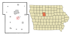
Webster County Iowa Incorporated and Unincorporated areas Otho Highlighted.svg
Location of Otho, Iowa
Coordinates: 42°25′29″N94°8′59″W / 42.42472°N 94.14972°W / 42.42472; -94.14972 Coordinates: 42°25′29″N94°8′59″W / 42.42472°N 94.14972°W / 42.42472; -94.14972
Country Flag of the United States.svg  United States
State Flag of Iowa.svg  Iowa
County Webster
Area
[1]
  Total0.44 sq mi (1.15 km2)
  Land0.44 sq mi (1.15 km2)
  Water0.00 sq mi (0.00 km2)
Elevation
1,122 ft (342 m)
Population
 (2020)
  Total429
  Density968.40/sq mi (374.13/km2)
Time zone UTC-6 (Central (CST))
  Summer (DST) UTC-5 (CDT)
ZIP code
50569
Area code 515
FIPS code 19-60105
GNIS feature ID0459915

Otho is a city in Webster County, Iowa, United States. The population was 429 at the time of the 2020 census. [2]

Contents

Geography

Otho is located at 42°25′29″N94°8′59″W / 42.42472°N 94.14972°W / 42.42472; -94.14972 (42.424739, -94.149588). [3]

According to the United States Census Bureau, the city has a total area of 0.46 square miles (1.19 km2), all land. [4]

Demographics

Historical populations
YearPop.±%
1960 593    
1970 581−2.0%
1980 692+19.1%
1990 529−23.6%
2000 571+7.9%
2010 542−5.1%
2020 429−20.8%
Source: "U.S. Census website". United States Census Bureau . Retrieved 2020-03-29. and Iowa Data Center
Source:
U.S. Decennial Census [5] [2]

2010 census

As of the census [6] of 2010, there were 542 people, 237 households, and 152 families living in the city. The population density was 1,178.3 inhabitants per square mile (454.9/km2). There were 260 housing units at an average density of 565.2 per square mile (218.2/km2). The racial makeup of the city was 97.6% White, 0.6% African American, 0.4% Native American, 0.2% Pacific Islander, 0.6% from other races, and 0.7% from two or more races. Hispanic or Latino of any race were 2.0% of the population.

There were 237 households, of which 28.7% had children under the age of 18 living with them, 50.2% were married couples living together, 8.9% had a female householder with no husband present, 5.1% had a male householder with no wife present, and 35.9% were non-families. 29.1% of all households were made up of individuals, and 12.7% had someone living alone who was 65 years of age or older. The average household size was 2.29 and the average family size was 2.80.

The median age in the city was 42.6 years. 22.1% of residents were under the age of 18; 8.5% were between the ages of 18 and 24; 22.2% were from 25 to 44; 30.3% were from 45 to 64; and 17% were 65 years of age or older. The gender makeup of the city was 52.2% male and 47.8% female.

2000 census

As of the census [7] of 2000, there were 571 people, 240 households, and 155 families living in the city. The population density was 1,281.2 inhabitants per square mile (494.7/km2). There were 245 housing units at an average density of 549.7 per square mile (212.2/km2). The racial makeup of the city was 97.20% White, 1.23% African American, 0.18% Native American, 0.18% Asian, 0.18% from other races, and 1.05% from two or more races. Hispanic or Latino of any race were 0.88% of the population.

There were 240 households, out of which 30.4% had children under the age of 18 living with them, 54.2% were married couples living together, 7.1% had a female householder with no husband present, and 35.4% were non-families. 30.0% of all households were made up of individuals, and 12.9% had someone living alone who was 65 years of age or older. The average household size was 2.38 and the average family size was 2.96.

26.3% were under the age of 18, 7.2% from 18 to 24, 27.5% from 25 to 44, 25.4% from 45 to 64, and 13.7% were 65 years of age or older. The median age was 39 years. For every 100 females, there were 100.4 males. For every 100 females age 18 and over, there were 97.7 males.

The median income for a household in the city was $34,318, and the median income for a family was $43,750. Males had a median income of $30,179 versus $22,375 for females. The per capita income for the city was $14,907. About 7.2% of families and 9.5% of the population were below the poverty line, including 11.6% of those under age 18 and 12.8% of those age 65 or over.

Education

Otho is within the Fort Dodge Community School District. [8] Otho residents are zoned to Butler Elementary School. [9] The district's sole secondary schools are Fort Dodge Middle School and Fort Dodge Senior High School.

Related Research Articles

<span class="mw-page-title-main">Ford County, Kansas</span> County in Kansas, United States

Ford County is a county located in the U.S. state of Kansas. As of the 2020 census, its population was 34,287. Its county seat and most populous city is Dodge City. The county is named in honor of Colonel James Hobart Ford.

<span class="mw-page-title-main">Webster County, Iowa</span> County in Iowa, United States

Webster County is a county in the U.S. state of Iowa. As of the 2020 census, the population was 36,999. The county seat is Fort Dodge. The county was established in January 1851, one of 43 counties established by a legislative package. This county was named after Daniel Webster, an American statesman noted for his moving oratory.

<span class="mw-page-title-main">Malden, Illinois</span> Village in Illinois, United States

Malden is a village in Bureau County, Illinois, United States. The population was 318 at the 2010 census. It is part of the Ottawa Micropolitan Statistical Area.

<span class="mw-page-title-main">Rinard, Iowa</span> City in Iowa, United States

Rinard is a city in Calhoun County, Iowa, United States. The population was 38 at the time of the 2020 census.

<span class="mw-page-title-main">Ayrshire, Iowa</span> City in Iowa, United States

Ayrshire is a city in Palo Alto County, Iowa, United States. The population was 133 at the 2020 census.

<span class="mw-page-title-main">Badger, Iowa</span> City in Iowa, United States

Badger is a city in Webster County, Iowa, United States. The population was 522 at the 2020 census.

<span class="mw-page-title-main">Callender, Iowa</span> City in Iowa, United States

Callender is a city in Webster County, Iowa, United States. The population was 368 at the time of the 2020 census.

<span class="mw-page-title-main">Coalville, Iowa</span> CDP in Iowa, United States

Coalville is a census-designated place (CDP) in Webster County, Iowa, United States. The population was 610 at the 2010 census. The community is located on U.S. Route 20 near Fort Dodge's large gypsum mines.

<span class="mw-page-title-main">Ashland, Kansas</span> City in Clark County, Kansas

Ashland is a city in and the county seat of Clark County, Kansas, United States. As of the 2020 census, the population of the city was 783.

<span class="mw-page-title-main">Dodge, Nebraska</span> Village in Nebraska, United States

Dodge is a village in Dodge County, Nebraska, United States. The population was 612 at the 2010 census.

<span class="mw-page-title-main">Fort Calhoun, Nebraska</span> City in Nebraska, United States

Fort Calhoun is a city in Washington County, Nebraska, United States. The population was 908 at the 2010 census. The city includes Fort Atkinson, the first fort built west of the Missouri River.

Gang Mills is a hamlet in Steuben County, New York, United States. The population was 4,185 at the 2010 census.

<span class="mw-page-title-main">Dodge, North Dakota</span> City in North Dakota, United States

Dodge is a city in Dunn County, North Dakota, United States. The population was 89 at the 2020 census. Dodge was founded in 1915.

<span class="mw-page-title-main">Lidgerwood, North Dakota</span> City in North Dakota, United States

Lidgerwood is a city in Richland County, North Dakota, United States. The population was 600 at the 2020 census. Lidgerwood was founded in 1886. It is part of the Wahpeton, ND–MN Micropolitan Statistical Area.

<span class="mw-page-title-main">North Bend, Ohio</span> Village in Ohio, United States

North Bend is a village in Miami Township, Hamilton County, Ohio, United States, along the Ohio River. It is a part of the Greater Cincinnati area. The population was 857 at the 2010 census.

<span class="mw-page-title-main">Shippingport, Pennsylvania</span> Borough in Pennsylvania, United States

Shippingport is a borough in western Beaver County, Pennsylvania, United States, located along the Ohio River. The population was 159 at the 2020 census. Shippingport is home to the Beaver Valley Nuclear Power Station and the Bruce Mansfield Power Plant. It is a part of the Pittsburgh metropolitan area.

<span class="mw-page-title-main">South Woodbury Township, Bedford County, Pennsylvania</span> Township in Pennsylvania, United States

South Woodbury Township is a township in Bedford County, Pennsylvania, United States. The population was 2,076 at the 2020 census.

<span class="mw-page-title-main">West Mead Township, Crawford County, Pennsylvania</span> Township in Pennsylvania, United States

West Mead Township is a township in Crawford County, Pennsylvania, United States. The population was 5,021 at the 2020 census, down from 5,249 at the 2010 census.

<span class="mw-page-title-main">Licking Creek Township, Fulton County, Pennsylvania</span> Township in Pennsylvania, United States

Licking Creek Township is a township in Fulton County, Pennsylvania, United States. The population was 1,562 at the 2020 census.

<span class="mw-page-title-main">Fort Dodge, Kansas</span> Unincorporated community in Ford County, Kansas

Fort Dodge is an unincorporated community in Grandview Township, Ford County, Kansas, United States. As of the 2020 census, the population of the community and nearby areas was 97. It is located on U.S. Route 400 5 miles (8 km) southeast of Dodge City. Fort Dodge has a post office with ZIP code 67843.

References

  1. "2020 U.S. Gazetteer Files". United States Census Bureau. Retrieved March 16, 2022.
  2. 1 2 "2020 Census State Redistricting Data". census.gov. United states Census Bureau. Retrieved 12 August 2021.
  3. "US Gazetteer files: 2010, 2000, and 1990". United States Census Bureau. 2011-02-12. Retrieved 2011-04-23.
  4. "US Gazetteer files 2010". United States Census Bureau. Archived from the original on 2012-01-25. Retrieved 2012-05-11.
  5. "Census of Population and Housing". Census.gov. Retrieved June 4, 2015.
  6. "U.S. Census website". United States Census Bureau . Retrieved 2012-05-11.
  7. "U.S. Census website". United States Census Bureau . Retrieved 2008-01-31.
  8. "Fort Dodge" (PDF). Iowa Department of Education . Retrieved 2020-04-05.
  9. "Elementary Boundary Map Final" (PDF). Fort Dodge Community School District . Retrieved 2020-04-05. - See text note in the lower left corner of the screen.