External links
Located in: San Diego, California | |||||||
| Colleges |  | ||||||
| Athletics |
| ||||||
| Media | |||||||
| Campus |
| ||||||
| Related | |||||||
| |||||||
| By topic |  | |
|---|---|---|
| Government | ||
| Emergency services | ||
| Transportation | ||
| Education |
| |
32°43′54″N117°12′37″W / 32.7318°N 117.2104°W
It is proposed that this article be deleted because of the following concern:
If you can address this concern by improving, copyediting, sourcing, renaming, or merging the page, please edit this page and do so. You may remove this message if you improve the article or otherwise object to deletion for any reason. Although not required, you are encouraged to explain why you object to the deletion, either in your edit summary or on the talk page. If this template is removed, do not replace it . The article may be deleted if this message remains in place for seven days, i.e., after 00:15, 9 January 2025 (UTC). Find sources: "Coastal and Marine Institute Laboratory" – news · newspapers · books · scholar · JSTOR Nominator: Please consider notifying the author/project: {{ subst:proposed deletion notify |Coastal and Marine Institute Laboratory|concern=Subject does not appear to be independently notable (and notability cannot be inherited from its unquestionably notable university) and there is already a suitable amount of information about this topic in the university article}} ~~~~ |
The Coastal and Marine Institute Laboratory (CMIL), formerly known as the Coastal Waters Laboratory, is an academic laboratory operated by the College of Sciences of San Diego State University (SDSU), in the Point Loma community of San Diego, California.
It is located on a coastal site at northern San Diego Bay, on the former grounds of the closed Naval Training Center San Diego, now part of the Liberty Station redevelopment project in Point Loma.
The laboratory focuses research on environmental and ecological problems on the Southern California Bight coastline in Southern California, caused by urbanization in the coastal environment at land-water interfaces, such as estuaries.
Data is transferred back from the laboratory via the High Performance Research and Education Network (HPWREN).
Adjacent to the CMIL laboratory complex is another research laboratory, operated by the Metropolitan Wastewater Department (MWWD) of the City of San Diego, in order to consolidate marine monitoring and analytical operations.
Together, this has created a “Coastal Zone Campus” on San Diego Bay to allow mutual access to and sharing of new and innovative research ideas and activities among federal regional, and local entities, and nationally known scientists and experts, in order to exchange information related to the coastal zone environment.
Located in: San Diego, California | |||||||
| Colleges | | ||||||
| Athletics |
| ||||||
| Media | |||||||
| Campus |
| ||||||
| Related | |||||||
| |||||||
| By topic | | |
|---|---|---|
| Government | ||
| Emergency services | ||
| Transportation | ||
| Education |
| |
32°43′54″N117°12′37″W / 32.7318°N 117.2104°W
Scripps Institution of Oceanography (SIO) is the center for oceanography and Earth science at the University of California, San Diego. Its main campus is located in La Jolla, with additional facilities in Point Loma.
The Moss Landing Marine Laboratories (MLML) is a multi-campus marine research consortium of the California State University System, headquartered at Moss Landing, California.

San Diego Bay is a natural harbor and deepwater port in San Diego County, California, near the Mexico–United States border. The bay, which is 12 miles (19 km) long and 1 to 3 miles wide, is the third largest of the three large, protected natural bays on California's 840 miles (1,350 km) of coastline, after San Francisco Bay and Humboldt Bay. The highly urbanized land adjacent to the bay includes the city of San Diego and four other cities: National City, Chula Vista, Imperial Beach and Coronado. The bay is considered to be one of the premier natural harbors on the West Coast.

The Coronado Islands are a group of islands located 13 km (8 mi) off the northwest coast of the Mexican state of Baja California. Battered by the wind and waves, the rocky islands are mostly uninhabited except for a small military detachment and a lighthouse keeper. Despite their barren appearance, they serve as a refuge for seabirds and support a sizable number of plants, including 6 endemic taxa found only on the islands. The waters around the islands support a considerable amount of diverse marine life.

The Southern California Bight is a 692-kilometer-long stretch of curved coastline that runs along the west coast of the United States and Mexico, from Point Conception in California to Punta Colonet in Baja California, plus the area of the Pacific Ocean defined by that curve. This includes the Channel Islands of California and the Coronado Islands and Islas de Todo Santos of Baja California.

San Diego Yacht Club (SDYC) is a private yacht club in San Diego, California. Founded in 1886, it is one of the oldest in the United States. The club won the America's Cup in 1987, 1988, and 1992.

The Back Bay is the colloquial term for the inland delta in Newport Beach, California. It connects the Upper Newport Bay with the Newport Harbor. It is a nature reserve home to several species of birds with hiking and biking trails. The bay is recognized for protection by the California Bays and Estuaries Policy.
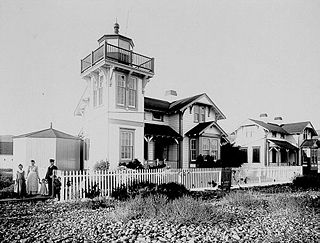
Ballast Point Lighthouse was a lighthouse in San Diego, California, situated on Ballast Point, a tiny peninsula extending into San Diego Bay from Point Loma. The lighthouse was torn down in 1960; the site is now on the grounds of Naval Base Point Loma. Ballast Point Lighthouse was the last lighthouse displaying a fixed light on the Pacific coast. An automated light is left in its place and operates on a piling in the water off of the original site.
San Diego–Tijuana is an international transborder agglomeration, straddling the border of the adjacent North American coastal cities of San Diego, California, United States, and Tijuana, Baja California, Mexico. The 2020 population of the region was 5,456,577, making it the largest bi-national conurbation shared between the United States and Mexico, and the second-largest shared between the US and another country. The conurbation consists of San Diego County, in the United States and the municipalities of Tijuana, Rosarito Beach (126,980), and Tecate (108,440) in Mexico. It is the third most populous region in the California–Baja California region, smaller only than the metropolitan areas of Greater Los Angeles and the San Francisco Bay Area.

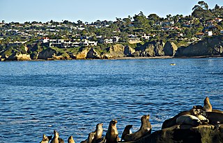
Point Loma is a seaside community in San Diego, California, United States. Geographically it is a hilly peninsula that is bordered on the west and south by the Pacific Ocean, the east by San Diego Bay and Old Town, and the north by the San Diego River. Together with the Silver Strand/Coronado peninsula, the Point Loma peninsula defines San Diego Bay and separates it from the Pacific Ocean. The term "Point Loma" is used to describe both the neighborhood and the peninsula.
Liberty Station is a mixed-use development in San Diego, California, on the site of the former Naval Training Center San Diego. It is located in the Point Loma community of San Diego. It has a waterfront location, on a boat channel off San Diego Bay, just west of San Diego International Airport and a few miles north of downtown San Diego. The 361-acre (1.46 km2) project includes several distinct districts: a retail and commercial district, a promenade focused on nonprofit activities, an arts district, educational district, residential district, hotel district, office district, and a park/open space area along the boat channel.
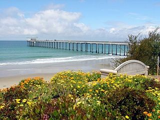
The San Diego-La Jolla Underwater Park is the historical name for a marine reserve that includes the San Diego-Scripps Coastal Marine Conservation Area (SMCA) and Matlahuayl State Marine Reserve (SMR), adjoining marine protected areas that extend offshore from La Jolla in San Diego County on California's south coast.

Midway is a neighborhood in San Diego, California. It is located at the northern (mainland) end of the Point Loma peninsula, northwest of downtown San Diego, and just west of Old Town. It is often considered to be part of Point Loma, although the city treats it as a separate planning area.
Roseville-Fleetridge is a neighborhood in Point Loma, a community of San Diego, California. It is bounded by San Diego Bay and Rosecrans Street to the east, Cañon Street to the south, Catalina Boulevard to the west and Chatsworth and Nimitz Boulevards to the north. Neighboring communities are Point Loma Heights and Loma Portal to the north, Point Loma Village and Liberty Station to the east, La Playa and the Wooded Area to the south, and Sunset Cliffs to the west. It is actually two separate neighborhoods, Roseville and Fleetridge, which the city lumps together for policing purposes.

Shelter Island is a neighborhood of Point Loma in San Diego, California, United States. It is actually not an island but is connected to the mainland by a narrow strip of land. It was originally a sandbank in San Diego Bay, visible only at low tide. It was built up into dry land using material dredged from the bay in 1934. It was developed in the 1950s and contains hotels, restaurants, marinas, and public parkland.

Lovers Point State Marine Reserve (SMR) is one of four small marine protected areas located near the cities of Monterey and Pacific Grove, at the southern end of Monterey Bay on California’s central coast. The four MPAs together encompass 2.96 square miles (7.7 km2). The SMR protects all marine life within its boundaries. Fishing and take of all living marine resources is prohibited.
The Southern California Coastal Water Research Project (SCCWRP) is a research institute focusing on the coastal ecosystems of Southern California from watersheds to the ocean. SCCWRP was created as a joint powers authority (JPA), which is an agency formed when multiple government agencies have a common mission that can be better achieved by pooling resources and knowledge. The purpose of SCCWRP is to gather the necessary scientific information to allow member agencies to effectively and cost-efficiently steward the Southern California coastal environment.

San Diego-Scripps Coastal Marine Conservation Area (SMCA) and Matlahuayl State Marine Reserve (SMR) are adjoining marine protected areas that extend offshore from La Jolla in San Diego County on California's south coast. The two marine protected areas cover 2.51 square miles (6.5 km2).
South La Jolla State Marine Conservation Area (SMCA) and South La Jolla State Marine Reserve (SMR) are two adjoining marine protected areas that extend offshore in San Diego County on California's south coast. The two marine protected areas cover 7.51 square miles (19.5 km2). The SMR protects marine life by prohibiting the removal of marine wildlife from within its borders, while the SMCA limits removal of marine wildlife.
Tijuana River Mouth State Marine Conservation Area is a marine protected area that extends offshore of southern San Diego County on California's south coast. The state marine conservation area (SMCA) covers 2.91 square miles (7.5 km2).