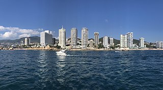
Acapulco de Juárez, commonly called Acapulco, is a city and major seaport in the state of Guerrero on the Pacific Coast of Mexico, 380 kilometres (240 mi) south of Mexico City. Acapulco is located on a deep, semicircular bay and has been a port since the early colonial period of Mexico's history. It is a port of call for shipping and cruise lines running between Panama and San Francisco, California, United States. The city of Acapulco is the largest in the state, far larger than the state capital Chilpancingo. Acapulco is also Mexico's largest beach and balneario resort city. Acapulco de Juárez is the municipal seat of the municipality of Acapulco.

The Aztecs were a Mesoamerican culture that flourished in central Mexico in the post-classic period from 1300 to 1521. The Aztec people included different ethnic groups of central Mexico, particularly those groups who spoke the Nahuatl language and who dominated large parts of Mesoamerica from the 14th to the 16th centuries. Aztec culture was organized into city-states (altepetl), some of which joined to form alliances, political confederations, or empires. The Aztec Empire was a confederation of three city-states established in 1427: Tenochtitlan, city-state of the Mexica or Tenochca, Texcoco, and Tlacopan, previously part of the Tepanec empire, whose dominant power was Azcapotzalco. Although the term Aztecs is often narrowly restricted to the Mexica of Tenochtitlan, it is also broadly used to refer to Nahua polities or peoples of central Mexico in the prehispanic era, as well as the Spanish colonial era (1521–1821). The definitions of Aztec and Aztecs have long been the topic of scholarly discussion ever since German scientist Alexander von Humboldt established its common usage in the early 19th century.

Guerrero, officially the Free and Sovereign State of Guerrero, is one of the 32 states that comprise the 32 Federal Entities of Mexico in Mexico. It is divided in 81 municipalities. The state has a population of about 3.5 million people. It is located in southwest Mexico and is bordered by the states of Michoacán to the north and west, the State of Mexico and Morelos to the north, Puebla to the northeast and Oaxaca to the east. In addition to the capital city, Chilpancingo and the largest city Acapulco, other cities in Guerrero include Petatlán, Ciudad Altamirano, Taxco, Iguala, Ixtapa, and Zihuatanejo. Today, it is home to a number of indigenous communities, including the Nahuas, Mixtecs, Tlapanecs, Amuzgos, and formerly Cuitlatecs. It is also home to communities of Afro-Mexicans in the Costa Chica region.
Misantla is a city in the Mexican state of Veracruz, the administrative seat of the municipality (municipio) of the same name. The municipality is bordered by Martínez de la Torre, Colipa and Papantla.

Pozole is a traditional soup or stew from Mexican cuisine. It is made from hominy with meat, and can be seasoned and garnished with shredded lettuce or cabbage, chilli peppers, onion, garlic, radishes, avocado, salsa or limes. Known in Mesoamerica since the pre-Columbian era, the stew is common across Mexico and neighboring countries, served both as a day-to-day meal and as a festive dish.

Iguala, known officially as Iguala de la Independencia, is a historic city located 102 km (63 mi) from the state capital of Chilpancingo, in the Mexican state of Guerrero in southwestern Mexico.

Amate is a type of bark paper that has been manufactured in Mexico since the precontact times. It was used primarily to create codices.

Huipil is the most common traditional garment worn by indigenous women from central Mexico to Central America.

Cotton duck, also simply duck, sometimes duck cloth or duck canvas, is a heavy, plain woven cotton fabric. Duck canvas is more tightly woven than plain canvas. There is also linen duck, which is less often used.

The traditions of indigenous Mesoamerican literature extend back to the oldest-attested forms of early writing in the Mesoamerican region, which date from around the mid-1st millennium BCE. Many of the pre-Columbian cultures of Mesoamerica are known to have been literate societies, who produced a number of Mesoamerican writing systems of varying degrees of complexity and completeness. Mesoamerican writing systems arose independently from other writing systems in the world, and their development represents one of the very few such origins in the history of writing.
The Codices Azoyú I & II are two Mesoamerican pictorial codices, painted in Tlapa around 1565. They were accidentally discovered in 1940 in the town of Azoyú, after which they are named. Both codices depict and offer supporting evidence for the Mesoamerican belief of nahualism.

Tlapa de Comonfort, often shortened to Tlapa and known as Tindaꞌi in Mixtec, is a city in the mountain region of the Mexican state of Guerrero. It also serves as the municipal seat for the surrounding municipality of the same name.

Ixcateopan de Cuauhtémoc is a town in Ixcateopan de Cuauhtémoc Municipality located in isolated, rugged mountains in the northern part of Guerrero state, Mexico. According to tradition, it is the final resting place of Aztec Emperor Cuauhtémoc, whose alleged remains were found under the parish church here in the mid-20th century. This church has been converted into a museum with displays a number of pre-Hispanic artifacts, offerings left in honor of the emperor and the alleged remains of Cuauhtémoc himself. This has been refuted by later research and by a Judging Commission of the Mexican government in 1976.
Cuajinicuilapa is one of the 81 municipalities of Guerrero, in southern Mexico. The municipal seat lies at Cuajinicuilapa. The municipality covers an area of 857.1 km². In 2020, the municipality had a total population of 26,627, up from 25,537 in 2005.
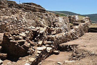
Ixcateopan is an archaeological site located in the town and municipality of Ixcateopan de Cuauhtémoc, 36 kilometers from Taxco, in the isolated and rugged mountains of the northern part of the Mexican state of Guerrero.
The 2012 Guerrero–Oaxaca earthquake struck southern Mexico with a moment magnitude of 7.4 at on Tuesday, 20 March. Its epicenter was near Ometepec, in the border between the states of Guerrero and Oaxaca. With a shallow focus of 20 km, the earthquake caused strong shaking over a large area along the Oaxaca–Guerrero border and the adjacent Pacific coastline. Significant tremors were felt in areas up to several hundred kilometers away, including Mexico City and also in Guatemala. Two people were killed and over 30,000 houses were damaged or destroyed.

Amuzgo textiles are those created by the Amuzgo indigenous people who live in the Mexican states of Guerrero and Oaxaca. The history of this craft extends to the pre-Columbian period, which much preserved, as many Amuzgos, especially in Xochistlahuaca, still wear traditional clothing. However, the introduction of cheap commercial cloth has put the craft in danger as hand woven cloth with elaborate designs cannot compete as material for regular clothing. Since the 20th century, the Amuzgo weavers have mostly made cloth for family use, but they have also been developing specialty markets, such as to collectors and tourists for their product.
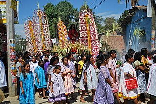
The Amuzgos are an indigenous people of Mexico. They primarily live in a region along the Guerrero/Oaxaca border, chiefly in and around four municipalities: Xochistlahuaca, Tlacoachistlahuaca and Ometepec in Guerrero, and San Pedro Amuzgos in Oaxaca. Their languages are similar to those of the Mixtec, and their territories overlap. They once dominated a larger area, from La Montaña down to the Costa Chica of Guerrero and Oaxaca, but Mixtec expansion, rule and later Spanish colonization has pushed them into the more inaccessible mountain regions and away from the coast. The Amuzgos maintain much of their language and dress and are known for their textiles, handwoven on backstrap looms with very intricate two-dimensional designs. The Amuzgo area is very poor with an economy mostly dependent on subsistence agriculture and handcraft production.

On September 26, 2014, forty-three male students disappeared from the Ayotzinapa Rural Teachers' College after being forcibly abducted in Iguala, Guerrero, Mexico. They were allegedly taken into custody by local police officers from Iguala and Cocula in collusion with organized crime. The mass kidnapping has caused continued international protests and social unrest, leading to the resignation of Guerrero Governor Ángel Aguirre Rivero in the face of statewide protests on October 23, 2014.

The Mexican State of Mexico produces various kinds of handcrafted items. While not as well documented as the work of other states, it does produce a number of notable items from the pottery of Metepec, the silverwork of the Mazahua people and various textiles including handwoven serapes and rebozos and knotted rugs. There are seventeen recognized handcraft traditions in the state, and include both those with pre Hispanic origins to those brought over by the Spanish after the Conquest. As the state industrializes and competition from cheaper goods increases, handcraft production has diminished. However, there are a number of efforts by state agencies to promote these traditions both inside and outside of Mexico.

