Route 49 is a state highway in the southern part of the U.S. state of New Jersey. It runs 53.80 mi (86.58 km) from an interchange with the New Jersey Turnpike, Interstate 295 (I-295), and U.S. Route 40 (US 40) in Deepwater, Salem County, southeast to Route 50 and County Route 557 in Tuckahoe, Cape May County. The route serves Salem, Cumberland, Atlantic, and Cape May Counties, passing through rural areas and the communities of Salem, Bridgeton, and Millville along the way. It is a two-lane, undivided road for most of its length.
Greenwich Township is the westernmost township in Cumberland County, New Jersey, United States. As of the 2010 United States Census, the township's population was 804, reflecting a decline of 43 (-5.1%) from the 847 counted in the 2000 Census, which had in turn declined by 64 (-7.0%) from the 911 counted in the 1990 Census. It is part of the Vineland-Millville- Bridgeton Primary Metropolitan Statistical Area for statistical purposes.

Hopewell Township is a township in Cumberland County, New Jersey, in the United States. It is part of the Vineland-Millville- Bridgeton Primary Metropolitan Statistical Area for statistical purposes. As of the 2010 United States Census, the township's population was 4,571, reflecting an increase of 137 (+3.1%) from the 4,434 counted in the 2000 Census, which had in turn increased by 219 (+5.2%) from the 4,215 counted in the 1990 Census.

Shiloh is a borough in Cumberland County, New Jersey, United States. It is part of the Vineland-Millville-Bridgeton Primary Metropolitan Statistical Area for statistical purposes. As of the 2010 United States Census, the borough's population was 516, reflecting a decline of 18 (-3.4%) from the 534 counted in the 2000 Census, which had in turn increased by 126 (+30.9%) from the 408 counted in the 1990 Census.

Delaware Bay is the estuary outlet of the Delaware River on the northeast seaboard of the United States. Approximately 782 square miles (2,030 km2) in area, the bay's fresh water mixes for many miles with the salt water of the Atlantic Ocean.

The New Jersey Pine Barrens, also known as the Pinelands or simply the Pines, is the largest remaining example of the Atlantic coastal pine barrens ecosystem, stretching across more than seven counties of New Jersey. Two other large, contiguous examples of this ecosystem remain in the northeastern United States: the Long Island Central Pine Barrens, and the Massachusetts Coastal Pine Barrens. The name pine barrens refers to the area's sandy, acidic, nutrient-poor soil. Although European settlers could not cultivate their familiar crops there, the unique ecology of the Pine Barrens supports a diverse spectrum of plant life, including orchids and carnivorous plants. The area is also notable for its populations of rare pygmy pitch pines and other plant species that depend on the frequent fires of the Pine Barrens to reproduce. The sand that composes much of the area's soil is referred to by the locals as sugar sand.

The Maurice River is a tributary of Delaware Bay in Salem County and Cumberland County, New Jersey in the United States. The river was named for Maurice, Prince of Orange.

The Cohansey River is a 30.6-mile-long (49.2 km) river in southern New Jersey in the United States. The river drains approximately 108 square miles (280 km2) of rural agricultural and forested lowlands on the north shore of Delaware Bay.
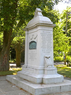
The Greenwich Tea Party was an incident that took place on December 22, 1774, early in the American Revolution, in Greenwich, a small community in Cumberland County, New Jersey, on the Cohansey River. That night, a load of tea meant to be sent overland into Philadelphia was torched by a group of 40 Patriots dressed as Native Americans. The event took place a year after the Boston Tea Party.
Cohansey Township was a township that existed in Cumberland County, New Jersey, United States, during two separate periods, from 1697 to 1748 and from 1848 to 1865. The name was derived from the Cohansey River, which flows through the area.
Mass Sarr Jr. is a Liberian retired footballer. A forward, Sarr Jr. is a former player with Selangor FA. He was also a Liberia national football team player from 1989–2002.
The Kirkwood-Cohansey aquifer is an aquifer system in the New Jersey Pine Barrens. It covers approximately 3,000 square miles (7,800 km2) and receives about 44 inches of precipitation each year. About fifty percent of this water is transpired by vegetation or evaporates back into the atmosphere. A small amount enters streams and rivers as storm runoff. About 17 to 20 inches annually actually enters the ground. Some of this water that enters the ground is pulled down through the soil and reaches the water table.

Roadstown is an unincorporated community located within Stow Creek Township, in Cumberland County, New Jersey, United States.
Othello is an unincorporated community located within Greenwich Township, Cumberland County, New Jersey, United States. It is part of the Greenwich Historic District, which has been on the National Register of Historic Places since 1972.

Seeley is a census-designated place (CDP) in Cumberland County, New Jersey, United States. It is in the northern part of the county, on the west side of Upper Deerfield Township. The western border of the CDP is the Cohansey River, which forms the border with Hopewell Township to the west. Seeley is 5 miles (8 km) north of Bridgeton, the county seat, and 13 miles (21 km) west of Vineland.
Greenwich is an unincorporated community and census-designated place (CDP) in Cumberland County, New Jersey, United States. It is in the western part of the county, in the southeast part of Greenwich Township, on the northwest side of the tidal Cohansey River, 4 miles (6 km) northeast of its mouth at Delaware Bay. The community is 7 miles (11 km) southwest of Bridgeton, the county seat.
Sheppards Mill is an unincorporated community and census-designated place (CDP) in Cumberland County, New Jersey, United States. It is in the western part of the county, in northeastern Greenwich Township and southwestern Hopewell Township. The community is centered on Mill Creek, which is dammed to form Sheppards Millpond in the northwestern part of the CDP. Mill Creek is a southwest-flowing tributary of Wheaton Run, part of the Cohansey River watershed leading to Delaware Bay.
Silver Lake is a census-designated place (CDP) in Cumberland County, New Jersey, United States. It is in the northern part of the county, in the southwest part of Upper Deerfield Township. It is bordered to the west by the Cohansey River, which forms the boundary with Hopewell Township, to the north by Seeley, and to the south by Sunset Lake. Bridgeton, the Cumberland county seat, is 3 miles (5 km) to the south.
Sunset Lake is a census-designated place (CDP) in Cumberland County, New Jersey, United States. It is in the northern part of the county, in the southwest corner of Upper Deerfield Township. It is bordered to the south by the city of Bridgeton, the county seat. It is bordered to the east by Laurel Heights, to the north by Silver Lake, and to the west by Sunset Lake, an impoundment on the Cohansey River. Across the lake is Hopewell Township.


