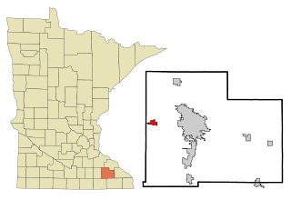
Stearns County is a county in the U.S. state of Minnesota. As of the 2020 census, the population was 158,292. Its county seat and largest city is St. Cloud.

Kayenta is a U.S. town which is part of the Navajo Nation and is in Navajo County, Arizona, United States. Established November 13, 1986, the Kayenta Township is unique in being the only "township" existing under the laws of the Navajo Nation.

Mount Pleasant is a city in the U.S. state of Michigan. The city is the county seat of Isabella County, which is part of Central Michigan. The population of Mount Pleasant was 21,688 as of the 2020 census. The city is surrounded by Union Charter Township, but is politically independent.

Cass Lake is a city in Cass County, Minnesota, United States, located within the boundaries of the Leech Lake Indian Reservation. It is surrounded by Pike Bay Township. Cass Lake had a population of 675 in the 2020 census. It is notable as the headquarters location of Minnesota Chippewa Tribe and Leech Lake Band of Ojibwe, as well as the Chippewa National Forest.

Willmar is a city in, and the county seat of, Kandiyohi County, Minnesota, United States. The population was 21,015 at the 2020 census.

Byron is a city in Olmsted County, Minnesota, United States, approximately five miles (8 km) west of Rochester on U.S. Route 14. It is surrounded by Kalmar Township. The population was 6,312 at the 2020 census.

Collegeville Township is a township in Stearns County, Minnesota, United States. The population was 3,344 at the 2020 census.

St. Joseph or Saint Joseph is a city in Stearns County, Minnesota, United States. The population was 7,029 at the 2020 census. It is home to the College of Saint Benedict.

Chanhassen is a city in Carver County, Minnesota about 16 miles southwest of Minneapolis. A small portion extends into Hennepin County. Located in the southwest Minneapolis–Saint Paul suburbs, there is a mix of suburban residential neighborhoods and rural landscapes. The population was 25,947 at the 2020 census, with a 2024 estimate of 26,469.
Kabetogama Township is a township in Saint Louis County, Minnesota, United States. The population was 135 at the 2010 census. A portion of the township is located within the Kabetogama State Forest.

The College of Saint Benedict and Saint John's University are two closely related private, Benedictine liberal arts colleges in Minnesota. The College of Saint Benedict is a college for women in St. Joseph and Saint John's University is a university for men in Collegeville. Students at the institutions have a shared curriculum and access to the resources of both campuses. Together, the College of Saint Benedict and Saint John's University offer over 70 areas of study to undergraduate students, plus graduate programs in nursing and theology.
Brimson is an unincorporated community in Ault Township, Saint Louis County, Minnesota, United States.

Rapid River is an unincorporated community in Masonville Township, Delta County in the U.S. state of Michigan.

Saint John's Abbey is a Benedictine monastery in Collegeville Township, Minnesota, United States, affiliated with the American-Cassinese Congregation. The abbey was established following the arrival in the area of monks from Saint Vincent Archabbey in Pennsylvania in 1856. Saint John's is one of the largest Benedictine abbeys in the Western Hemisphere, with 110 professed monks. The Right Reverend Fr. Doug Mullin, OSB, serves as the eleventh abbot.
Cotton is an unincorporated community in Cotton Township, Saint Louis County, Minnesota, United States.

Saint John’s Preparatory School (SJP) is a Catholic co-educational, day and boarding college preparatory school located in Collegeville, Minnesota. Founded in 1857, it is located in the Diocese of Saint Cloud and is administered by the Benedictine monks of Saint John's Abbey. The school includes a middle school consisting of grades 6–8 and an upper school consisting of grades 9–12. The student body consists of students from the local area along with 5- and 7-day boarding students from across the United States and around the world. In the 2018–19 academic year, the student body included students from 24 different cities and towns in Minnesota, 4 states and 13 different countries.
Santiago is an unincorporated community in Santiago Township, Sherburne County, Minnesota, United States, near the junction of Sherburne County Roads 3 and 11. The St. Francis River flows through the community.
Beaulieu is a census-designated place and unincorporated community in Beaulieu and Chief townships, Mahnomen County, Minnesota, United States. Its population was 103 as of the 2020 census.
Nett Lake is an unincorporated community and census-designated place (CDP) in Nett Lake Territory, Saint Louis County, Minnesota, United States; located on the shore of Nett Lake. As of the 2020 census, its population was 230.

Joshua Guimond is an American man who disappeared on the night of November 9 and 10, 2002, after leaving a party hosted in a dormitory of Saint John's University in Collegeville, Minnesota. He was a 20-year-old junior student at Saint John's, who was partying with friends in the campus' Metten Court dormitory building. He left the party around 11:45 p.m. on the 9th without saying anything. When he did not return, the students at the party assumed that he had gone to sleep elsewhere. The walk to his dormitory, St. Maur, would have taken about three minutes. He was last seen around 12:15 to 12:30 a.m. on the 10th, on a bridge near Stumpf Lake, which is located in between the two buildings.


