The Middlesex and Boston Street Railway (M&B) was a streetcar and later bus company in the area west of Boston. Streetcars last ran in 1930, and in 1972, the company's operations were merged into the Massachusetts Bay Transportation Authority (MBTA).

The B branch, also called the Commonwealth Avenue branch or Boston College branch, is a branch of the MBTA Green Line light rail system which operates on Commonwealth Avenue west of downtown Boston, Massachusetts. One of four branches of the Green Line, the B branch runs from Boston College station down the median of Commonwealth Avenue to Blandford Street. There, it enters Blandford Street portal into Kenmore station, where it merges with the C and D branches. The combined services run into the Boylston Street subway and Tremont Street subway to downtown Boston. B branch service has terminated at Government Center since October 2021. Unlike the other branches, B branch service runs solely through the city limits of Boston. The Green Line Rivalry between Boston College and Boston University is named in reference to the B branch, which runs to both universities.

Revere Beach Parkway is a historic parkway in the suburbs immediately north of Boston, Massachusetts. It begins at Wellington Circle in Medford, where the road leading to the west is Mystic Valley Parkway, and the north–south road is the Fellsway, designated Route 28. The parkway proceeds east, ending at Eliot Circle, the junction of Revere Beach Boulevard and Winthrop Parkway in Revere. In between, the parkway passes through the cities of Everett and Chelsea. The parkway was built between 1896 and 1904 to provide access from interior communities to Revere Beach. It underwent two major periods of capacity expansion, in the 1930s and again in the 1950s. The parkway is designated as part of Route 16 west of Route 1A, and as part of Route 145 east of that point.

Commonwealth Avenue is a major street in the cities of Boston and Newton, Massachusetts. It begins at the western edge of the Boston Public Garden, and continues west through the neighborhoods of the Back Bay, Kenmore Square, Boston University, Allston, Brighton and Chestnut Hill. It continues as part of Route 30 through Newton until it crosses the Charles River at the border of the town of Weston.

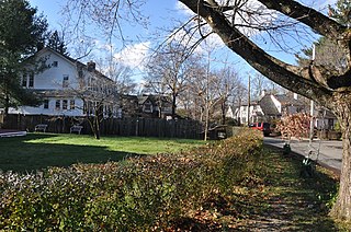
The Newtonville Historic District is a historic district in the village of Newtonville, in Newton, Massachusetts. The district encompasses the southern portion of the village's business district, as well as surrounding residential areas. It was listed on the National Register of Historic Places in 1986, and enlarged in 1990.

The Newton City Hall and War Memorial is a historic city hall and war memorial building located in the village of Newton Centre in Newton, Massachusetts. Built in 1932 in the Colonial Revival style, the building was designed by Allen and Collens, with landscaping by the renowned Olmsted Brothers. The building's purpose was to serve as a new city hall, and as a memorial to the city's soldiers of the First World War. On February 16, 1990, it was added to the National Register of Historic Places.

The Lower Roxbury Historic District is a historic district encompassing an isolated pocket of 1890s mixed residential-commercial property in the lower Roxbury neighborhood of Boston, Massachusetts. Bounded by Tremont, Columbus, and Burke Streets and St. Cyprian's Place, the area contains a well-kept collection of architect designed buildings that survived late 20th-century urban redevelopment. The district was added to the National Register of Historic Places in 1994.

Winthrop Parkway is a historic parkway in Revere, Massachusetts. The parkway, built between 1909 and 1919 and now designated as part of Route 145, runs for about 0.75 miles (1.21 km), from Eliot Circle southeast to the Revere-Winthrop line. Acquisitions for its construction represent the last public purchase of oceanfront lands in Revere. It was listed on the National Register of Historic Places in 2004.

The Charles River Reservation Parkways are parkways that run along either side of the Charles River in eastern Massachusetts. The roads are contained within the Charles River Reservation and the Upper Charles River Reservation, and fall within a number of communities in the greater Boston metropolitan area. The Charles River parks extend from the Charles River Dam, where the Charles empties into Boston Harbor, to Riverdale Park in the West Roxbury neighborhood of Boston. Most of the roadways within the parks are listed on the National Register of Historic Places as a unit, although Storrow Drive and Memorial Drive are listed as part of the Charles River Basin Historic District.

The Middlesex Fells Reservation Parkways are the roadways within and bordering on the Middlesex Fells Reservation, a state park in the northern suburbs of Boston, Massachusetts, United States. The park includes portions of the towns of Malden, Medford, Melrose, Stoneham, and Winchester. The roads inside the park and around its perimeter have been listed on the National Register of Historic Places. Other portions of some of the roads are covered by more than one listing in the national register; see Fellsway Connector Parkways and Middlesex Fells Reservoirs Historic District.

The Day Estate Historic District encompasses part of a subdivided estate at the corner of Commonwealth Avenue and Dartmouth Street in Newton, Massachusetts, United States. The district is bounded by Commonwealth, Dartmouth, Chestnut, and Prince Streets, and includes six houses located on Commonwealth and Dartmouth. It was originally owned by Henry Day, a banker, who in 1896 built the house at 321 Chestnut Street. The block was subdivided during a building boom in the 1920s, and the new houses were built between 1928 and 1930. All six houses are high quality Tudor Revival structures, five of them designed by William J. Freethey. Day's estate house is now home to the All Newton Music School, and the rest of the northeastern portion of the estate has more modern construction. The district was listed on the National Register of Historic Places in 1990.

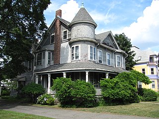
The Monadnock Road Historic District is a residential historic district encompassing a cohesive subdivision of a former estate in the 1920s in the Chestnut Hill section of Newton, Massachusetts. The development was typical of Newton's explosive residential growth at that time, and includes primarily Tudor Revival houses. The district was listed on the National Register of Historic Places in 1990.
The Morton Road Historic District encompasses an example of a small residential subdivision in Newton, Massachusetts that was attractively designed in 1915. The architect-designed subdivision filled in an area otherwise surrounded by roads that had been developed earlier, and was built out between 1915 and 1928, with a fairly uniform use of Craftsman and Tudor Revival styling. The district was listed on the National Register of Historic Places in 1990.
The Newton Highlands Historic District encompasses the historic heart of the village of Newton Highlands in Newton, Massachusetts. When it was added to the National Register of Historic Places in 1986, the district extended along Lincoln Street from Woodward to Hartford Streets, and included blocks of Bowdoin, Erie and Hartford Streets south of Lincoln Street. The district was enlarged in 1990 to include the cluster of commercial buildings on Lincoln Street between Hartford and Walnut Streets.

The Union Street Historic District is a historic district on Union Street between Langley Road and Herrick Road, and at 17–31 Herrick Road in Newton, Massachusetts. It encompasses the city's only significant cluster of 19th century commercial buildings. It was added to the National Register of Historic Places in 1986.

Blue Hills Parkway is a historic parkway that runs in a straight line from a crossing of the Neponset River, at the south border of Boston to the north edge of the Blue Hills Reservation in Milton, Massachusetts. It was built in 1893 to a design by the noted landscape architect, Charles Eliot, who is perhaps best known for the esplanades along the Charles River. The parkway is a connecting road between the Blue Hills Reservation and the Neponset River Reservation, and was listed on the National Register of Historic Places in 2003.

Hammond Pond Parkway is a historic parkway in Chestnut Hill, Massachusetts. The road, built in 1932, extends 2 miles (3.2 km) from Hobart Road in Newton to Horace James Circle in Brookline, where it joins the West Roxbury Parkway. It was designed by Charles Eliot and the Olmsted Brothers to provide a parkway setting that provided access from Brookline, Newton, and the western portions of Boston to the southern parks of the Emerald Necklace. The parkway was listed on the National Register of Historic Places in 2004.

West Roxbury Parkway is a historic parkway running from Washington Street in Boston, Massachusetts, where the Enneking Parkway runs south, to Horace James Circle in Chestnut Hill, where it meets the Hammond Pond Parkway. The parkway serves as a connector between Stony Brook Reservation and Hammond Pond Reservation. West Roxbury Parkway was built between 1919 and 1929 and added to the National Register of Historic Places in 2006. The parkway is distinctive in the roadway system developed by the Metropolitan District Commission beginning around the turn of the 20th century in that it was built in collaboration with the City of Boston, and is maintained by the city.
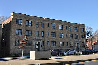
The Almont Apartments are historic apartment houses at 1439-43 and 1447-51 Blue Hill Avenue in the Mattapan neighborhood of Boston, Massachusetts. Built in 1926, they are well-preserved examples of Colonial Revival architecture, built during a period of growth fueled by the city's expanding streetcar network. The apartments were listed on the National Register of Historic Places in 2014.

The Walnut Park Historic District is a historic district encompassing a cluster of multifamily brick buildings in the Roxbury neighborhood of Boston, Massachusetts. Roughly centered on the junction of Walnut Park and Waldren Road, the area was developed in the early 20th century during a major Jewish migration, and includes a fine sample of Colonial Revival architecture. The district was listed on the National Register of Historic Places in 2022.


