
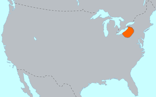
Lancaster County, sometimes nicknamed the Garden Spot of America or Pennsylvania Dutch Country, is a county in the Commonwealth of Pennsylvania. As of the 2020 census, the population was 552,984, making it Pennsylvania's sixth-most populous county. Its county seat is also Lancaster. Lancaster County comprises the Lancaster metropolitan statistical area. The county is part of the South Central region of the state.

Bird-in-Hand is an unincorporated community and census-designated place (CDP) in Lancaster County, Pennsylvania, United States, in East Lampeter Township. The "Bird in Hand" ZIP code extends east from the CDP into Leacock and Upper Leacock townships. The community has a large Amish and Mennonite population. As of the 2010 census, the population within the CDP was 402.

Strasburg is a borough in Lancaster County, Pennsylvania, United States. It developed as a linear village stretching approximately 2 miles (3 km) along the Great Conestoga Road, later known as the Strasburg Road. The population was 3,117 at the 2020 census.

Manor Township is a second-class township in west-central Lancaster County, Pennsylvania, United States. As of the 2020 census, it had a population of 21,920.

The Beaver Wars, also known as the Iroquois Wars or the French and Iroquois Wars were a series of conflicts fought intermittently during the 17th century in North America throughout the Saint Lawrence River valley in Canada and the Great Lakes region which pitted the Iroquois against the Hurons, northern Algonquians and their French allies. As a result of this conflict, the Iroquois destroyed several confederacies and tribes through warfare: the Hurons or Wendat, Erie, Neutral, Wenro, Petun, Susquehannock, Mohican and northern Algonquins whom they defeated and dispersed, some fleeing to neighbouring peoples and others assimilated, routed, or killed.

The Susquehannock, also known as the Conestoga, Minquas, and Andaste, were an Iroquoian people who lived in the lower Susquehanna River watershed in what is now Pennsylvania. Their name means “people of the muddy river.”

The Paxton Boys, also known as the Paxtang Boys or the Paxton Rangers, were a mob of settlers that murdered 20 unarmed Conestoga in Lancaster County, Pennsylvania, in December 1763. This group of vigilantes from Lancaster and Cumberland counties formed in 1763 to defend themselves from Indigenous attacks during Pontiac's War. The Paxton Boys justified their actions by claiming that the Conestoga were colluding with the Lenape and Shawnee who were attacking Pennsylvania's frontier settlements. According to historian Kevin Kenny, the Paxton Boys were Pennsylvania's most aggressive colonists.

The Conestoga River, also referred to as Conestoga Creek, is a 61.6-mile-long (99.1 km) tributary of the Susquehanna River flowing through the center of Lancaster County, Pennsylvania, United States.
The Erie people were Indigenous people historically living on the south shore of Lake Erie. An Iroquoian group, they lived in what is now western New York, northwestern Pennsylvania, and northern Ohio before 1658. Their nation was almost exterminated in the mid-17th century by five years of prolonged warfare with the powerful neighboring Iroquois for helping the Huron in the Beaver Wars for control of the fur trade. Captured survivors were adopted or enslaved by the Iroquois.

Pequea Creek is a tributary of the Susquehanna River that runs for 49.2 miles (79.2 km) from the eastern border of Lancaster County and Chester County, Pennsylvania to the village of Pequea, about 5 miles (8 km) above the hydroelectric dam at Holtwood along the Susquehanna River in Lancaster County.

Conestoga is an unincorporated community and census-designated place (CDP) in Conestoga Township, Lancaster County, Pennsylvania, United States. At the 2020 census, the population was 1,163. The Conestoga post office serves ZIP code 17516.

Susquehannock State Park is a Pennsylvania state park on 224 acres (91 ha) in Drumore Township, Lancaster County, Pennsylvania in the United States. The park is on a scenic plateau overlooking the Susquehanna River and Conowingo Reservoir. The park is named for the Susquehannock people, who lived in the area. Susquehannock State Park is located on small roads a few miles south of Pennsylvania Route 372 and west of Pennsylvania Route 272. The nearest city is Quarryville, Pennsylvania, about 12 miles (19 km) East.
Captain Lazarus Stewart was an 18th-century Pennsylvanian frontiersman, a leader of the Paxton Boys, and a prominent commander on the Yankee side in the Pennamite–Yankee War. He met his death during the Revolutionary War in battle with Loyalists and Haudenosaunee at the Battle of Wyoming.

The Conrad Weiser Homestead was the home of Johann Conrad Weiser, who enlisted the Iroquois on the British side in the French and Indian War. The home is located near Womelsdorf, Berks County, Pennsylvania in the United States. A designated National Historic Landmark, it is currently administered as a historic house museum by the Pennsylvania Historical and Museum Commission. The historic site was established in 1923 to preserve an example of a colonial homestead and to honor Weiser, an important figure in the settlement of the colonial frontier.
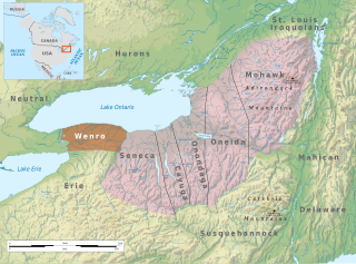
The Wenrohronon or Wenro people were an Iroquoian indigenous nation of North America, originally residing in present-day western New York, who were conquered by the Confederation of the Five Nations of the Iroquois in two decisive wars between 1638–1639 and 1643. This was likely part of the Iroquois Confederacy campaign against the Neutral people, another Iroquoian-speaking tribe, which lived across the Niagara River. This warfare was part of what was known as the Beaver Wars, as the Iroquois worked to dominate the lucrative fur trade. They used winter attacks, which were not usual among Native Americans, and their campaigns resulted in attrition of both the larger Iroquoian confederacies, as they had against the numerous Huron.

Great Minquas Path was a 17th-century trade route that ran through southeastern Pennsylvania from the Susquehanna River, near Conestoga, to the Schuylkill River, opposite Philadelphia. The 80-mile (130 km) east-west trail was the primary route for fur trading with the Minquas people. Dutch, Swedish and English settlers fought one another for control of it.
The Roberts Farm Site (36LA1) is an historic, American archaeological site that is located above the Conestoga River in Manor Township in Lancaster County, Pennsylvania.
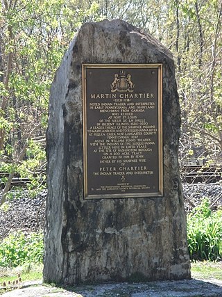
Martin Chartier was a French-Canadian explorer and trader, carpenter and glove maker. He lived much of his life amongst the Shawnee Native Americans in what is now the United States.
Opessa Straight Tail, also known as Wopatha or Wapatha, was a Pekowi Shawnee Chief. He was the son of Straight Tail Meaurroway Opessa. He is best known for signing, on 23 April 1701, the "Articles of friendship and agreement between William Penn and the Susquehannah, Shawonah, and North Patomack Indians," that designated lands and conditions of coexistence between those tribes and the English settlers.
John Hansson Steelman, also known as "Hance" Stillman, Stelman, Tilghman, or Tillmann (1655–1749), the eldest son of Hans Månsson and Ella Olofsdotter Stille. He was a fur trader and interpreter who traded with Shawnee, Susquehannock and Piscataway Indians in Maryland and Pennsylvania. Steelman made substantial donations to support the construction of the Holy Trinity Church Church, probably covering as much as a third of the building costs. He died in 1749 in Adams County, Pennsylvania at the age of 94.


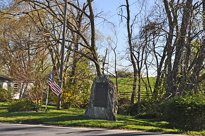 Marker on the roadside
 Plaque

