Cooke City, Montana

Last updated

Cooke City, Montana
2003-08-17 Entering Cooke City from the East.jpg
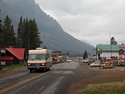
Entering Cooke City from the east
USA Montana location map.svg
Red pog.svg
Cooke City
Usa edcp location map.svg
Red pog.svg
Cooke City
Coordinates: 45°00′57″N109°53′24″W / 45.01583°N 109.89000°W / 45.01583; -109.89000
CountryUnited States
State Montana
County Park
Area
[1]
  Total
9.54 sq mi (24.70 km2)
  Land9.54 sq mi (24.70 km2)
  Water0.00 sq mi (0.00 km2)
Elevation
[2]
8,127 ft (2,477 m)
Population
 (2020)
  Total
77
  Density8.08/sq mi (3.12/km2)
Time zone UTC-7 (Mountain (MST))
  Summer (DST) UTC-6 (MDT)
ZIP Code
59020
Area code 406
FIPS code 30-17350
GNIS feature ID2583800 [2]

Cooke City is an unincorporated community and census-designated place (CDP) in Park County, Montana, United States. As of the 2020 census, it had a population of 77. [3] Prior to 2010, it was part of the Cooke City-Silver Gate CDP.

Contents

The community sits northeast of Yellowstone National Park on the Beartooth Highway, which leads east to Red Lodge, Montana, on a scenic route climbing to 10,947 feet (3,337 m) in elevation through the Beartooth Mountains and across the Beartooth Plateau. The town's chief industry is tourism, which during the winter includes skiing and snowmobiling.

It is named for Jay Cooke, financier of the Northern Pacific Railroad. [4]

Geography

Cooke City is near the southeast corner of Park County, bordered to the south by the North Absaroka Wilderness within Shoshone National Forest in the state of Wyoming, and to the west by the community of Silver Gate, Montana. The two towns sit in the valley of Soda Butte Creek, which flows southwest into Wyoming to join the Lamar River in Yellowstone National Park. The valley is part of the Yellowstone River watershed.

U.S. Route 212, the Beartooth Highway, passes through the center of Cooke City, leading southwest into Yellowstone National Park, and east over 8,040-foot (2,450 m) Colter Pass in the eastern part of the CDP to continue southeast back into Wyoming in the valley of the Clarks Fork Yellowstone River and thence into the Beartooth Mountains.

Climate

Cooke City has a subarctic climate (Dfc) or subalpine climate due its extremely high elevation, at 7,580 feet (2,310 m), with only two months averaging above 50 °F (10 °C). Summers consist of mild to warm days with crisp, cool mornings, and winters are long and very cold, with many nights falling below zero. Snowfall is abundant, with most of it falling between the months of October to May, though snow does occasionally fall in the months of June and September. Cooke City is listed as the snowiest community in Montana. [5]

Climate data for Cooke City, Montana, 1991–2020 normals, extremes 1946–2013 [a]
MonthJanFebMarAprMayJunJulAugSepOctNovDecYear
Record high °F (°C)48
(9)
54
(12)
58
(14)
74
(23)
80
(27)
88
(31)
100
(38)
90
(32)
86
(30)
85
(29)
60
(16)
47
(8)
100
(38)
Mean maximum °F (°C)37.8
(3.2)
44.2
(6.8)
51.4
(10.8)
61.2
(16.2)
71.1
(21.7)
79.9
(26.6)
84.9
(29.4)
82.7
(28.2)
77.1
(25.1)
66.2
(19.0)
48.1
(8.9)
36.3
(2.4)
85.3
(29.6)
Mean daily maximum °F (°C)24.2
(−4.3)
28.6
(−1.9)
36.9
(2.7)
43.4
(6.3)
53.5
(11.9)
63.9
(17.7)
73.7
(23.2)
71.1
(21.7)
62.0
(16.7)
47.0
(8.3)
30.9
(−0.6)
22.4
(−5.3)
46.5
(8.0)
Daily mean °F (°C)15.0
(−9.4)
18.0
(−7.8)
25.3
(−3.7)
32.2
(0.1)
40.9
(4.9)
49.2
(9.6)
56.3
(13.5)
54.4
(12.4)
46.6
(8.1)
35.5
(1.9)
22.1
(−5.5)
14.3
(−9.8)
34.2
(1.2)
Mean daily minimum °F (°C)5.8
(−14.6)
7.4
(−13.7)
13.7
(−10.2)
21.0
(−6.1)
28.4
(−2.0)
34.5
(1.4)
38.9
(3.8)
37.7
(3.2)
31.2
(−0.4)
24.1
(−4.4)
13.3
(−10.4)
6.3
(−14.3)
21.9
(−5.6)
Mean minimum °F (°C)−23.1
(−30.6)
−24.5
(−31.4)
−13.4
(−25.2)
−0.4
(−18.0)
14.5
(−9.7)
25.6
(−3.6)
30.6
(−0.8)
28.7
(−1.8)
18.3
(−7.6)
5.8
(−14.6)
−10.7
(−23.7)
−22.7
(−30.4)
−32.2
(−35.7)
Record low °F (°C)−51
(−46)
−47
(−44)
−40
(−40)
−18
(−28)
1
(−17)
16
(−9)
22
(−6)
12
(−11)
3
(−16)
−13
(−25)
−36
(−38)
−50
(−46)
−51
(−46)
Average precipitation inches (mm)2.23
(57)
2.04
(52)
1.94
(49)
2.29
(58)
2.85
(72)
3.16
(80)
1.97
(50)
1.82
(46)
1.74
(44)
2.23
(57)
2.17
(55)
2.13
(54)
26.57
(674)
Average snowfall inches (cm)38.8
(99)
29.7
(75)
31.0
(79)
22.4
(57)
9.0
(23)
3.4
(8.6)
0.0
(0.0)
0.0
(0.0)
1.0
(2.5)
13.4
(34)
26.5
(67)
37.9
(96)
213.1
(541.1)
Average precipitation days (≥ 0.01 in)17.313.313.113.114.114.511.110.49.511.613.417.2158.6
Average snowy days (≥ 0.1 in)17.012.611.39.44.00.80.00.00.86.711.816.490.8
Source 1: XMACIS2 (mean maxima/minima 19812010) [6]
Source 2: NOAA [7]

Demographics

Historical population
CensusPop.Note
2020 77
U.S. Decennial Census [8]

Education

The CDP is in Cooke City Elementary School District and Gardiner High School District [9] The high school district is a component of Gardiner Public Schools. [10]

Notes

  1. Records from January 1946 to October 1967 were at Yellowstone National Park's Northeast Entrance. From November 1967 to 2013 records were at a station approximately 2 miles (3.2 km) west of the city.

Related Research Articles

<span class="mw-page-title-main">Park County, Montana</span> County in Montana, United States

Park County is a county in the U.S. state of Montana. At the 2020 census, the population was 17,191. Its county seat is Livingston. A small part of Yellowstone National Park is in the southern part of the county.

<span class="mw-page-title-main">Carbon County, Montana</span> County in Montana, United States

Carbon County is a county located in the U.S. state of Montana. As of the 2020 census, the population was 10,473. Its county seat is Red Lodge.

<span class="mw-page-title-main">Crow Agency, Montana</span> Census designated place in Montana, United States

Crow Agency is a census-designated place (CDP) in Big Horn County, Montana, United States and is near the actual location for the Little Bighorn National Monument and re-enactment produced by the Real Bird family known as Battle of the Little Bighorn Reenactment. The population was 1,616 at the 2010 census. It is the governmental headquarters of the Crow Nation Native Americans. It is also the location of the "agency offices" where the federal Superintendent of the Crow Indian Reservation and his staff interacts with the Crow Tribe, pursuant to federal treaties and statutes.

<span class="mw-page-title-main">Cooke City-Silver Gate, Montana</span> Former CDP in Montana, United States

Cooke City-Silver Gate was a census-designated place (CDP) in Park County, Montana, United States, corresponding to the unincorporated communities of Cooke City and Silver Gate. The population was 140 at the 2000 census. Starting with the 2010 census, the two communities were listed as separate CDPs. The communities sit toward the northeast of Yellowstone National Park on the Beartooth Highway.

<span class="mw-page-title-main">Gardiner, Montana</span> Unincorporated community in Park County, Montana, United States

Gardiner is a census-designated place (CDP) in Park County, Montana, United States, along the 45th parallel. As of the 2020 census, the population of the community and nearby areas was 833.

<span class="mw-page-title-main">Livingston, Montana</span> City in Park County, Montana, United States

Livingston, is a city and county seat of Park County, Montana, United States. It is in southwestern Montana, on the Yellowstone River, north of Yellowstone National Park. As of the 2020 census, the population of the city was 8,040.

<span class="mw-page-title-main">Billings, Montana</span> Largest city in Montana, U.S.

Billings is the most populous city in the U.S. state of Montana, with a population of 117,116 as of the 2020 census. Located in the south-central portion of the state, it is the seat of Yellowstone County and the principal city of the Billings Metropolitan Area, which had a population of 184,167 in the 2020 census. With one of the largest trade areas in the United States, Billings is the trade and distribution center for much of Montana east of the Continental Divide. Billings is also the largest retail destination for much of the same area. The Billings Chamber of Commerce claims the area of commerce covers more than 125,000 square miles (320,000 km2). In 2009, it was estimated to serve over 500,000 people.

<span class="mw-page-title-main">Huntley, Montana</span> CDP in Montana, United States

Huntley is a census-designated place (CDP) in Yellowstone County, Montana, United States. The population was 411 at the 2000 census. Huntley lent its name to the Huntley Project, a federal irrigation project that began delivering water to the arid district in 1907. Today, Huntley is an eastern suburb of Billings and is located east of Shepherd and west of Worden.

<span class="mw-page-title-main">Jackson, Wyoming</span> Town in Wyoming, United States

Jackson is a resort town in Teton County, Wyoming, United States. The population was 10,760 at the 2020 census, up from 9,577 in 2010. It is the largest town in Teton County and its county seat. Jackson is the principal town of the Jackson, WY-ID Micropolitan Statistical Area, which includes Teton County in Wyoming and Teton County in Idaho. The town is often called Jackson Hole which is the name of the valley in which it is located. Jackson is a popular tourist destination due to its proximity to the ski resorts Jackson Hole Mountain, Snow King Mountain, and Grand Targhee, as well as Grand Teton National Park and Yellowstone National Park.

<span class="mw-page-title-main">Big Sky, Montana</span> Census-designated place in Montana, United States

Big Sky is an unincorporated community and census-designated place (CDP) in Gallatin and Madison counties in southwestern Montana, United States. As of the 2020 census, it had a population of 3,591, up from 2,308 in 2010. It is 44 miles (71 km) by road southwest of Bozeman. The primary industry of the area is tourism.

<span class="mw-page-title-main">Absaroka Range</span> Mountain range in Montana and Wyoming, United States

The Absaroka Range is a sub-range of the Rocky Mountains in the United States. The range stretches about 150 mi (240 km) across the Montana–Wyoming border, and 75 mi (120 km) at its widest, forming the eastern boundary of Yellowstone National Park along Paradise Valley, and the western side of the Bighorn Basin. The range borders the Beartooth Mountains to the north and the Wind River Range to the south. The northern edge of the range rests along I-90 and Livingston, Montana. The highest peak in the range is Francs Peak, located in Wyoming at 13,153 ft (4,009 m). There are 46 other peaks over 12,000 ft (3,700 m).

<span class="mw-page-title-main">Beartooth Highway</span> Scenic road in Montana and Wyoming, United States

The Beartooth Highway is an All-American Road in the western United States on a section of U.S. Route 212 in Montana and Wyoming between Red Lodge and the Northeast entrance of Yellowstone National Park. It crests at Beartooth Pass in Wyoming at 10,947 feet (3,337 m) above sea level, and was called "the most beautiful drive in America," by late CBS News correspondent Charles Kuralt. Because of heavy snowfall at the top, the pass is usually open for about five months per year, from mid-May to mid-October, weather conditions permitting.

<span class="mw-page-title-main">Gallatin National Forest</span> National Forest in Montana, US

The Gallatin National Forest is a United States National Forest located in South-West Montana. Most of the Custer-Gallatin goes along the state's southern border, with some of it a part of North-West Wyoming.

<span class="mw-page-title-main">Absaroka–Beartooth Wilderness</span> Protected wilderness area in Montana and Wyoming, United States

Absaroka–Beartooth Wilderness was created from existing National Forest lands in 1978 and is located in Montana and Wyoming, United States. The wilderness encompasses two distinct mountain ranges: the Beartooth and Absaroka ranges. These ranges are completely distinct geologically speaking, with the Absaroka composed primarily of volcanic and metamorphic rock, while the Beartooth is made up almost entirely of granitic rocks. The Absaroka are noted for their dark and craggy appearance, lush and heavily forested valleys, and abundant wildlife. The highest peak in the range, in Wyoming, is Francs Peak at 13,153 feet (4,009 m). The Beartooth is more alpine, with huge treeless plateaus and the highest peak of Montana. The wilderness has more than 120 peaks over 10,000 feet (3,000 m) and 28 peaks over 12,000 feet (3,700 m), including Montana's highest, Granite Peak at 12,799 feet (3,901 m). The wilderness is integral to the 20-million-acre (81,000 km2) Greater Yellowstone Ecosystem and borders Yellowstone National Park.

<span class="mw-page-title-main">Emigrant, Montana</span> Unincorporated community in Montana, United States

Emigrant is an unincorporated community in Park County, Montana, United States. As of the 2010 census, the ZIP Code Tabulation Area (59027) for Emigrant had a population of 372. Emigrant is located in southern Montana, on the Yellowstone River, approximately 30 miles (48 km) north of Yellowstone National Park, and 20 miles (32 km) south of Livingston.

Silver Gate is an unincorporated community and census-designated place (CDP) in Park County, Montana, United States. As of the 2010 census, it had a population of 20. Prior to 2010, it was part of the Cooke City-Silver Gate CDP.

Savage is an unincorporated community and census-designated place (CDP) in Richland County, Montana, United States. Savage is located on the Yellowstone River and Montana Highway 16, 20 miles (32 km) south-southwest of Sidney.

<span class="mw-page-title-main">Mountain states</span> Region of the United States

The Mountain states form one of the nine geographic divisions of the United States that are officially recognized by the United States Census Bureau. It is a subregion of the Western United States.

<span class="mw-page-title-main">New World Mining District</span> Area of mineralization in Park County, Montana, United States

The New World Mining District is an area of mineralization that sits within Gallatin National Forest to the northeast of Cooke City and Yellowstone National Park, in Park County, Montana, United States. The district hosts extensive deposits of gold, silver and copper in zones of carbonate replacement. These deposits are the result of Eocene hydrothermal alteration of Cambrian carbonates related to the Absaroka volcanic field. Alteration and mineralization occur primarily within carbonate clasts hosted in a volcanic breccia pipe and in carbonate rocks that lie adjacent to that breccia.

<span class="mw-page-title-main">Mammoth, Wyoming</span> Census-designated place in Wyoming, United States

Mammoth is a census-designated place in Park County, Wyoming, United States, comprising Fort Yellowstone and Mammoth Hot Springs in Yellowstone National Park. As of the 2010 census, its population was 263.

References

  1. "ArcGIS REST Services Directory". United States Census Bureau. Retrieved September 5, 2022.
  2. 1 2 U.S. Geological Survey Geographic Names Information System: Cooke City, Montana
  3. "Cooke City CDP, Montana". data.census.gov. U.S. Census Bureau. Retrieved April 11, 2023.
  4. "Cooke City". Montana Place Names Companion. Montana Historical Society. Retrieved April 2, 2021.
  5. "Average Annual Snowfall in Montana". currentresults.com. Retrieved June 14, 2021.
  6. "xmACIS2". National Oceanic and Atmospheric Administration. Retrieved May 26, 2023.
  7. "U.S. Climate Normals Quick Access". National Oceanic and Atmospheric Administration. Retrieved August 7, 2022.
  8. "Census of Population and Housing". Census.gov. Retrieved June 4, 2016.
  9. "2020 CENSUS - SCHOOL DISTRICT REFERENCE MAP: Park County, MT" (PDF). U.S. Census Bureau . Retrieved October 4, 2024. - Text list
  10. "Directory of Montana Schools". Montana Office of Public Instruction. March 13, 2024. pp. 203/317. Retrieved October 4, 2024.