
Cotuit is one of the villages of the Town of Barnstable on Cape Cod in Barnstable County, Massachusetts, United States. Located on a peninsula on the south side of Barnstable about midway between Falmouth and Hyannis, Cotuit is bounded by the Santuit River to the west on the Mashpee town line, the villages of Marstons Mills to the north and Osterville to the east, and Nantucket Sound to the south. Cotuit is primarily residential with several small beaches including Ropes Beach, Riley's Beach, The Loop Beach and Oregon Beach.

The Nantucket Historic District is a National Historic Landmark District that encompasses the entire island of Nantucket, Massachusetts. The original December 13, 1966 listing on the National Register of Historic Places included only the historic downtown core and the village of Siasconset, but was expanded in 1975 to include the entire island, as well as the islands of Tuckernuck and Muskeget. At over 30,000 acres, it is the largest conventional historic National Historic Landmark District by area in the contiguous United States.

The Lower Highlands Historic District encompasses one of the oldest residential areas of Fall River, Massachusetts. The district is roughly bounded by Cherry, Main, Winter, and Bank Streets, and is located just east of the Downtown Fall River Historic District and directly south of the Highlands Historic District. This area was settled by 1810, has architecture tracing the city's growth as a major industrial center. The historic district was added to the National Register of Historic Places in 1984.

The Wianno Historic District is a historic district in the Osterville section of Barnstable, Massachusetts. It encompasses a well-preserved summer resort area for the wealthy that was first developed in the late 19th century, focused around the Wianno Club, built in 1881 on the site of an earlier resort hotel. The 40-acre (16 ha) district has a significant number of well-preserved Shingle style and Colonial Revival houses. Architect Horace Frazer designed the Wianno Club, as well as a number of the private residences in the district. The district is roughly bounded by East Bay Road, Wianno and Sea View Avenues between Nantucket Sound and Crystal Lake. It was added to the National Register of Historic Places in 1987.

The Wellfleet Center Historic District is a historic district in Wellfleet, Massachusetts, United States. It encompasses resources that exemplify the development of the community, beginning in the late 18th century, as a thriving commercial maritime center, and then its rise as a summer resort community in the late 19th century. Buildings in the district include Cape-style houses from the mid-18th century, 19th century commercial and institutional buildings in the town center, and the 1880s summer estate of Lorenzo Dow Baker. The district is roughly bounded by Cross St., Holbrook Ave., Main, E. Main and School Streets, and Duck Creek, and was listed on the National Register of Historic Places in 1989.
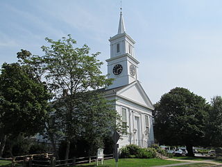
The Centerville Historic District is a historic district encompassing the heart of the village of Centerville in Barnstable, Massachusetts. The district extends along Main Street from a point north of its junction with Old Stage Road and Park Avenue, south to the junction with Church Hill Road. Most of the buildings in the district were built in the middle decades of the 19th century, although its oldest building, the Austin Bearse House, was built c. 1690. The area's growth was spurred by the relocation in 1826 of the Congregational Church building to its present location. The district was listed on the National Register of Historic Places in 1987.

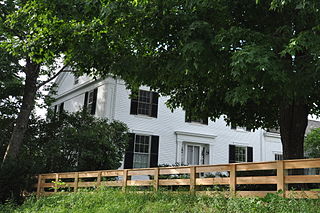
The Col. Charles Codman Estate is a historic house on Bluff Point Drive in Barnstable, Massachusetts. Built in 1870, the house is a well-preserved example of a summer seaside resort house in Queen Anne/Shingle style. It was designed by Boston architect John Sturgis, and modified in the early 20th century, adding some Colonial Revival elements. The estate was listed on the National Register of Historic Places in March 1987, and it was included in the Cotuit Historic District in November 1987.

The Falmouth Village Green Historic District is a historic district encompassing the historic village center of Falmouth, Massachusetts. It is centered on the triangular village green formed by Main Street, West Main Street, and Hewins Street, and extends south on Locust Street to the Old Town Cemetery. This area has been the town center since 1756, and is architecturally dominated by late Colonial and Federal period buildings. The district was added to the National Register of Historic Places in 1996.

The Mill Way Historic District encompasses a residential area significant in the development of the maritime industry in Barnstable Village, Massachusetts. It includes thirteen houses, ten on Mill Way and three on adjacent Freezer Road, just north of the Old King's Highway. The district was listed on the National Register of Historic Places in 1987.

The North Falmouth Village Historic District encompasses the historic 19th-century village of North Falmouth, Massachusetts, which is a village in the town of Falmouth, Massachusetts. It is a linear district, extending along Old Main Road south from its junction with Massachusetts Route 28A to Winslow Road. This area gradually developed over the 19th century, principally in support of maritime activities centered on Buzzards Bay to the west. The district contains a cross-section of architectural styles popular from the early 19th to early 20th centuries. It was listed on the National Register of Historic Places in 1998.

The Northside Historic District encompasses two of the earliest significant settlement areas of Yarmouth, Massachusetts. Stretching along Massachusetts Route 6A from the Barnstable line in the west to White Brook in the east, the district includes almost 300 buildings on 50 acres (20 ha). It includes the two villages of Yarmouth Center and Yarmouthport, which were important 18th and 19th century centers of civic and economic activity.

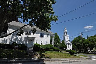
The Old King's Highway Historic District encompasses what was historically the principal east–west thoroughfare through Barnstable, Massachusetts. It encompasses Barnstable's entire length of what is now designated Massachusetts Route 6A, called Main Street, between the town lines of Sandwich and Yarmouth. It includes more than 1,000 acres (400 ha) and all buildings whose properties are front on the road, nearly 500 in all. The area consists of the main population centers of Barnstable from its founding in the late 1630s until the mid-19th century when the southern parts of the community became more significant in economic prominence. The district was listed on the National Register of Historic Places in 1987.

The Pleasant–School Street Historic District is a predominantly residential historic district in the Hyannis village of Barnstable, Massachusetts. It includes 37 properties on Pleasant and School Streets, between Main and South Streets, near the center of Hyannis. Pleasant Street was laid out in the 18th century, and School Street was laid out c. 1850, and is distinctive for its cohesive collection of Greek Revival cottages, most of which were owned by mariners active in the coasting trade. The district was listed on the National Register of Historic Places in 1987.

The U.S. Customshouse is a historic customs house and United States Coast Guard museum on Cobbs Hill in Barnstable, Massachusetts. Built in 1855 to a design by Ammi Young, it was used as a custom house and post office until 1913, continuing to house the post office and other offices until 1958. It was converted into a museum in 1960, and was listed on the National Register of Historic Places in 1975.

The South Yarmouth/Bass River Historic District is a historic district in the southeastern part of Yarmouth, Massachusetts. It encompasses a predominantly residential area centered on a portion of Old Main Street and South Street between the villages of South Yarmouth and Bass River. The area's history is one of maritime-related industry from the late 18th to late 19th century, and then its growth as a tourist resort community. The district was listed on the National Register of Historic Places in 1990.
Church Street Historic District is a historic district roughly on Church Street between Park Ave. and Highland St. in Ware, Massachusetts. This mainly residential area includes some of Ware's finest late 19th century houses and a well-preserved collection of Greek Revival houses. The area was developed primarily in response to the growth of industry to the south. The district was listed on the National Register of Historic Places in 1983.

The Parsons, Shepherd, and Damon Houses Historic District is a historic district on the east side of downtown Northampton, Massachusetts encompassing a 2.5-acre (1.0 ha) property that was first laid out in 1654. Now owned by Historic Northampton, the property includes three houses built between 1730 and 1830. The district was added to the National Register of Historic Places in 2001.

The East Leverett Historic District of Leverett, Massachusetts, encompasses the historic mill village of East Leverett. Centered on the intersection of Cushman Road and Shutesbury Road in the southeastern portion of the rural town, it includes predominantly residential buildings that were built during the height of the area's industrial activity in the first four decades of the 19th century. The architecture is mainly Federal and Greek Revival in style. The district was listed on the National Register of Historic Places in 2014.
The Harraseeket Historic District encompasses some of the oldest maritime village areas of the town of Freeport, Maine. It includes properties along both banks of the tidal Harraseeket River, from the Mast Landing area in the north to Wolf Neck and the villages of Porter's Landing and South Freeport on the west bank of the river. The district was listed on the National Register of Historic Places in 1974.
The South Chatham Village Historic District is a historic district encompassing much of the linear village of South Chatham in Chatham, Massachusetts. Extending eastward from the Harwich town line along Main Street, the district developed in the 18th and 19th centuries as a maritime and farming village. The district was listed on the National Register of Historic Places in 2022.


