Covenant Life, Alaska

Last updated

Covenant Life, Alaska
USA Alaska location map.svg
Red pog.svg
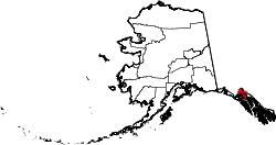
Covenant Life
Location in Alaska
Coordinates: 59°24′0″N136°4′35″W / 59.40000°N 136.07639°W / 59.40000; -136.07639
Country United States
State Alaska
Borough Haines
Government
  Borough mayor Janice Hill [1]
   State senator Jesse Kiehl (D)
   State rep. Andi Story (D)
Area
[2]
  Total27.25 sq mi (70.58 km2)
  Land27.05 sq mi (70.07 km2)
  Water0.20 sq mi (0.51 km2)
Elevation
259 ft (79 m)
Population
 (2020)
  Total25
  Density0.92/sq mi (0.36/km2)
Time zone UTC-9 (Alaska (AKST))
  Summer (DST) UTC-8 (AKDT)
ZIP code
99827 [3]
Area code 907
FIPS code 02-17670
GNIS feature ID1866938

Covenant Life is a census-designated place (CDP) in Haines Borough, Alaska, United States. At the 2020 census the population was 25, [4] down from 86 at the 2010 census.

Contents

It is a community of people with common religious beliefs, with a panel of church elders who set policy for the community's common church, K-12 school, and private 4-year university, and a loose form of self- (municipal) government. An emphasis on community living is a key value in their lifestyle, such as taking most meals together in a common meeting place. The community was established during a Christian religious movement in the 1960s and 1970s, where many such communities were established in Alaska and Canada, with emphasis on self-sufficiency and at least partial agricultural independence. The latter lends to the term often used by outsiders as "The Farm", in reference to a single such community. Modern technology is not forbidden, nor discouraged, but due to remoteness and complete lack of public utilities, it is present much less so than in American and Canadian culture.

Geography

Covenant Life is located in northern Haines Borough at 59°24′0″N136°4′35″W / 59.40000°N 136.07639°W / 59.40000; -136.07639 (59.400046, -136.076433), [5] between the Klehini River to the north and the Tsirku River to the south. The eastern end of the CDP is at the Chilkat River. Covenant Life is bordered by the Mosquito Lake CDP to the north and by the community of Klukwan to the east. The turnoff to Covenant Life from Alaska Route 7 is 25 miles (40 km) northwest of Haines.

According to the United States Census Bureau, the CDP has a total area of 27.2 square miles (70.5 km2), of which 27.1 square miles (70.1 km2) are land and 0.2 square miles (0.5 km2), or 0.64%, are water. [4]

Demographics

Historical population
CensusPop.Note
1990 47
2000 102117.0%
2010 86−15.7%
2020 25−70.9%
U.S. Decennial Census [6]

Covenant Life first appeared on the 1990 U.S. Census as a census-designated place (CDP).

As of the census [7] of 2000, there were 102 people, 25 households, and 22 families residing in the CDP. The population density was 3.9 people per square mile (1.5 people/km2). There were 38 housing units at an average density of 1.5 per square mile (0.58/km2). The racial makeup of the CDP was 94.12% White, 0.98% Native American, 3.92% Asian, and 0.98% from two or more races.

There were 25 households, out of which 44.0% had children under the age of 18 living with them, 84.0% were married couples living together, 4.0% had a female householder with no husband present, and 12.0% were non-families. 4.0% of all households were made up of individuals, and none had someone living alone who was 65 years of age or older. The average household size was 4.08 and the average family size was 3.59.

In the CDP, the population was spread out, with 26.5% under the age of 18, 15.7% from 18 to 24, 18.6% from 25 to 44, 32.4% from 45 to 64, and 6.9% who were 65 years of age or older. The median age was 35 years. For every 100 females, there were 75.9 males. For every 100 females age 18 and over, there were 63.0 males.

The median income for a household in the CDP was $34,167, and the median income for a family was $41,250. Males had a median income of $36,875 versus $22,083 for females. The per capita income for the CDP was $14,326. There were 4.5% of families and 15.2% of the population living below the poverty line, including no under eighteens and 12.5% of those over 64.

See also

Related Research Articles

<span class="mw-page-title-main">Haines Borough, Alaska</span> Borough in Alaska, United States

Haines Borough is a home-rule borough located in the state of Alaska. As of the 2020 census, the population was 2,080, down from 2,508 in 2010.

<span class="mw-page-title-main">Kongiganak, Alaska</span> CDP in Alaska, United States

Kongiganak is a census-designated place (CDP) in Bethel Census Area, Alaska, United States, and primarily sits on the eastern shore of the Kongiganak River. As of the 2010 census, the population was 439, up from 359 in 2000.

<span class="mw-page-title-main">Tuluksak, Alaska</span> CDP in Alaska, United States

Tuluksak is a census-designated place (CDP) in Bethel Census Area, Alaska, United States. At the 2010 census the population was 373, down from 428 in 2000.

<span class="mw-page-title-main">Twin Hills, Alaska</span> Census-designated place in Alaska, United States

Twin Hills is a census-designated place (CDP) in Dillingham Census Area, Alaska, United States. The population was 74 at the 2010 census, up from 69 in 2000.

<span class="mw-page-title-main">Excursion Inlet, Alaska</span> Census-designated place in Alaska, United States

Excursion Inlet is a census-designated place (CDP) in Haines Borough in the U.S. state of Alaska. The population was 40 at the 2020 census, up from 12 in 2010.

<span class="mw-page-title-main">Lutak, Alaska</span> Census-designated place in Alaska, United States

Lutak is a census-designated place (CDP) in Haines Borough, Alaska, United States. The population was 49 at the 2010 census, up from 39 in 2000.

<span class="mw-page-title-main">Mosquito Lake, Alaska</span> Census-designated place in Alaska, United States

Mosquito Lake is a census-designated place (CDP) in Haines Borough, Alaska, United States. At the 2010 census the population was 309, up from 221 at the 2000 census.

<span class="mw-page-title-main">Mud Bay, Alaska</span> Census-designated place in Alaska, United States

Mud Bay is a census-designated place (CDP) in Haines Borough, Alaska, United States. At the 2010 census the population was 212, up from 137 at the 2000 census.

<span class="mw-page-title-main">Anchor Point, Alaska</span> Census-designated place in Alaska, United States

Anchor Point is an unincorporated community and census-designated place (CDP) in Kenai Peninsula Borough, in the U.S. state of Alaska. As of the 2010 census the population was 1,930, up from 1,845 in 2000. The community is located along the Sterling Highway, part of Alaska State Route 1. Anchor Point is the westernmost point in the North American highway system.

<span class="mw-page-title-main">Cohoe, Alaska</span> Census-designated place in Alaska, United States

Cohoe (Dena'ina: Qughuhnaz’ut) is a census-designated place (CDP) in Kenai Peninsula Borough, Alaska, United States. At the 2010 census the population was 1,364, up from 1,168 in 2000.

<span class="mw-page-title-main">Fox River, Alaska</span> Census-designated place in Alaska, United States

Fox River is a census-designated place (CDP) in Kenai Peninsula Borough, Alaska, United States. At the 2010 census the population was 685, up from 616 in 2000. It was first reported by the U.S. Geological Survey in 1895. The Fox River, which flows by the CDP, might have been named for Theodore Fox, a local mining magnate.

<span class="mw-page-title-main">Nikolaevsk, Alaska</span> Census-designated place in Alaska, United States

Nikolaevsk is a census-designated place (CDP) in Kenai Peninsula Borough in the U.S. state of Alaska. As of the 2020 census, the population of the CDP is 328, up from 318 in 2010. Nikolaevsk School serves school-age children from the area.

Seldovia Village is a census-designated place (CDP) in Kenai Peninsula Borough, Alaska, United States. At the 2010 census the population was 165, up from 144 in 2000. Seldovia Village is not to be confused with the adjacent city of Seldovia.

<span class="mw-page-title-main">Levelock, Alaska</span> Census-designated place in Alaska, United States

Levelock is a census-designated place (CDP) along the Kvichak River in Lake and Peninsula Borough, Alaska, United States. It was known by the indigenous name of Kivichakh, a variant of Kvichak. At the 2020 census the population was 69, same amount as in 2010.

Pope-Vannoy Landing is a census-designated place (CDP) in the Lake and Peninsula Borough in the U.S. state of Alaska. The population was six at the 2020 census, same amount as in 2010.

<span class="mw-page-title-main">Petersville, Alaska</span> Census-designated place in Alaska, United States

Petersville is a census-designated place (CDP) in Matanuska-Susitna Borough, Alaska, United States. It is part of the Anchorage Metropolitan Area. The population was 27 at the 2020 census.

<span class="mw-page-title-main">Elfin Cove, Alaska</span> Census-designated place in Alaska, United States

Elfin Cove is a census-designated place (CDP) near the northwestern corner of Chichagof Island in Hoonah-Angoon Census Area, Alaska, United States. The population was 20 at the 2010 census, down from 32 at the 2000 census.

<span class="mw-page-title-main">Klukwan, Alaska</span> Census-designated place in Alaska, United States

Klukwan is a census-designated place (CDP) in Alaska, United States. It is technically in Hoonah-Angoon Census Area, though it is an enclave of Haines Borough. At the 2010 census the population was 95, down from 139 at the 2000 census.

<span class="mw-page-title-main">Circle, Alaska</span> CDP in Alaska, United States

Circle is a census-designated place (CDP) in Yukon-Koyukuk Census Area, Alaska, United States. At the 2010 census the population was 104, up from 100 in 2000.

<span class="mw-page-title-main">Woodward, Pennsylvania</span> Census-designated place in Pennsylvania, United States

Woodward is an unincorporated community and census-designated place in Haines Township, Centre County, Pennsylvania, United States. It is part of the State College, Pennsylvania, Metropolitan Statistical Area. The population was 110 at the 2010 census.

References

  1. 2015 Alaska Municipal Officials Directory. Juneau: Alaska Municipal League. 2015. p. 7.
  2. "2020 U.S. Gazetteer Files". United States Census Bureau. Retrieved October 29, 2021.
  3. "Covenant Life AK ZIP Code". zipdatamaps.com. 2023. Retrieved June 16, 2023.
  4. 1 2 "Geographic Identifiers: 2010 Demographic Profile Data (G001): Covenant Life CDP, Alaska". American Factfinder. U.S. Census Bureau. Retrieved April 13, 2017.[ dead link ]
  5. "US Gazetteer files: 2010, 2000, and 1990". United States Census Bureau. February 12, 2011. Retrieved April 23, 2011.
  6. "U.S. Decennial Census". Census.gov. Retrieved June 6, 2013.
  7. "U.S. Census website". United States Census Bureau . Retrieved January 31, 2008.

59°24′00″N136°04′35″W / 59.400046°N 136.076433°W / 59.400046; -136.076433