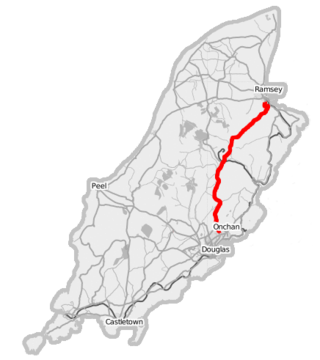
The A18 Snaefell Mountain Road or Mountain Road is a primary main A-road of 13.35 miles (21.48 km) in length which connects the towns of Douglas and Ramsey in the Isle of Man.

The Isle of Man TT Mountain Course or TT Course or Snaefell Mountain Course or Elmo’s Mountain Course is a street and public rural road circuit located in the Isle of Man, used for motorcycle racing. The motorcycle TT Course is used principally for the Isle of Man TT Races and also the separate event of the Isle of Man Festival of Motorcycling for the Manx Grand Prix and Classic TT Races held in September of each year. The start-line for the Isle of Man TT Mountain Course is located on Glencrutchery Road in the City of Douglas, Isle of Man.

The Clypse Course describes a motor-cycle racing course used for the Isle of Man TT Races between 1954 and 1959.

Keppel Gate, Isle of Man is part of a former UK HM Commissioners of Woods and Forest estate, including a series of former highway mountain gates. It is now Common land in public ownership and is one of three purpose built former Crown Road sections of the A18 Snaefell Mountain Road used for the Isle of Man TT races. The area of Keppel Gate including a nearby private residence of Kate's Cottage at the adjacent 34th TT Milestone road-side marker is located between the 4th Milestone and 5th Milestone road-side markers on the primary A18 Snaefell Mountain Road in the parish district of Kirk Onchan in the Isle of Man.

Creg-ny-Baa is located between the 3rd Milestone and 4th Milestone of the primary A18 Snaefell Mountain Road and the road junction with the secondary B12 'Creg-ny-Baa Back-Road', in the parish of Kirk Onchan in the Isle of Man.

Governor's Bridge is a hairpin bend adjacent to a road junction on the primary A18 Mountain Road in the parish of Onchan in the Isle of Man, with a sudden drop in elevation leading to Governor's Dip, followed by a left-hand bend and finally a right exiting on to the main Glencrutchery Road.
Parliament Square, Ramsey is situated between the 23rd and 24th Milestone road-side markers on the Snaefell Mountain Course used for the Isle of Man TT Races on the junction of the primary A3 Castletown to Ramsey road, the A9 Ramsey to Andreas road and A2 Douglas to Ramsey road situated in the town of Ramsey in the parish of Lezayre in the Isle of Man.
The Four Inch Course was a road-racing circuit first used for the 1908 Tourist Trophy Race for cars, held on public roads closed for racing by an Act of Tynwald. The name of the course derives from the regulations for the 1908 Tourist Trophy adopted by the Royal Automobile Club, which limited the competitors' engines to a cylinder-diameter of four inches. The Four-Inch Course was adopted by the Auto-Cycle Club for the 1911 Isle of Man TT Races. The Four-Inch Course was subsequently known as the Snaefell Mountain Course or Mountain Course when used for motor-cycle racing.

Brandywell, Isle of Man or is an area of Mountain Lands of heath moorland and coniferous woodland plantations situated in the Northern Upland Massif in the parish of Kirk Michael in the Isle of Man. The area was previously used by local shepherds due to a local stream and a nearby former venerated water well which was known for its distinctive quality and "brandy" colour of the water.

Brandish Corner is situated between the 35th and 36th Milestone road-side markers on the Snaefell Mountain Course on the primary A18 Mountain Road in the parish of Onchan in the Isle of Man. The road was re-engineered in recent years.

Kate's Cottage, Isle of Man is a cottage and one of the named corners of the Snaefell Mountain Course used in Grand Prix-style motorcycle racing along public roadways of the Isle of Man. It has been asserted in the Isle of Man's program of Registered Buildings that the cottage was built by 1869.

The Bungalow, Isle of Man, one of a handful of better-known vantage points spread around the Snaefell Mountain Course, is situated adjacent to the 31st Milestone roadside marker on the road junction of the primary A18 Mountain Road, the A14 Sulby Glen Road and the road-tramway crossing for the Snaefell Mountain Railway in the parish of Lezayre in the Isle of Man.

Sarah's Cottage is situated between the 11th milestone and 12th milestones on Creg Willey’s Hill on the primary A3 Castletown to Ramsey Road in the parish of Kirk German in the Isle of Man.

Hillberry Corner is situated at the 36th Milestone road-side marker on the Snaefell Mountain Course, being on the primary A18 Mountain Road with the side-road junction of the C22 Little Mill Road, in the parish of Onchan in the Isle of Man.

Gob-ny-Geay is situated at the 35th Milestone on the Snaefell Mountain Course on the primary A18 Mountain Road in the parish of Onchan in the Isle of Man.
Appledene is situated between the 6th and 7th roadside mile-markers, measured from the startline of the Snaefell Mountain Course used for the Isle of Man TT races, on the primary A1 Douglas to Peel road in the Isle of Man parish of German.
Glen Helen or Lambfell Glen) is one of a series of eighteen Manx National Glens owned and maintained by the Forestry Amenity and Lands Directorate of the Isle of Man Department of Environment, Food and Agriculture.

Cronk-ny-Mona is situated between the 36 and 37 mile markers used for the Snaefell Mountain Course, being on the primary A18 Mountain Road at the road junction with the A21 Johnny Watterson('s) Lane and the tertiary C10 Scholag Road in the Isle of Man parish of Onchan.
Ballacobb is situated between the 16th and 17th Milestone road-side markers on the Snaefell Mountain Course, on the primary A3 Castletown to Ramsey road at the side-junction with the tertiary U16 Slieu Curn Road, in the parish of Ballaugh in the Isle of Man.
This page is based on this
Wikipedia article Text is available under the
CC BY-SA 4.0 license; additional terms may apply.
Images, videos and audio are available under their respective licenses.