
Back of Keppoch is a small coastal settlement in the northwest Scottish Highlands, 40 miles west of Fort William near to the A830 road to Mallaig.

Erica vagans, the Cornish heath or wandering heath, is a species of flowering plant in the family Ericaceae, native to Ireland, Cornwall, western France and Spain. It is a vigorous, spreading, evergreen heather reaching 75 cm (30 in) tall and wide, with pink flowers borne in racemes 14 cm (6 in) long in summer and autumn. The Latin specific epithet vagans literally means "wandering"; in this context it means "widely distributed".

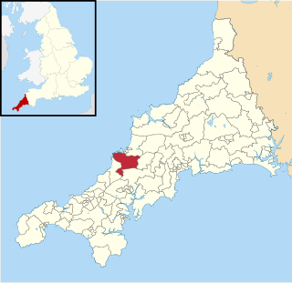
St Hilary is a civil parish and village in west Cornwall, England, United Kingdom. It is situated approximately five miles (8 km) east of Penzance and four miles (6.5 km) south of Hayle.

Mullion is a civil parish and village on the Lizard Peninsula in south Cornwall, England, United Kingdom. The nearest town is Helston approximately 5 miles (8 km) to the north.

Gurnard's Head is a prominent headland on the north coast of the Penwith peninsula in Cornwall, England. The name is supposed to reflect that the rocky peninsula resembles the head of the gurnard fish.

Carnmenellis Hill gives its name to the area of west Cornwall in England, between Redruth, Helston and Penryn. The hill itself is situated approximately three miles (5 km) south of Redruth. It is one of five Marilyns in Cornwall; the others being Brown Willy, Kit Hill, Hensbarrow Beacon and Watch Croft. The natural region of Carnmenellis has been designated as national character area 155 by Natural England.
Bolenowe is a village in west Cornwall, England, United Kingdom. It is approximately one-and-a-half miles (2 km) southeast of Camborne. It consists of cottages that are spread apart by large gardens, the only amenities are a post box and a red phone box that has now been decommissioned.

Bornesketaig, Scottish Gaelic Borgh na Sgiotaig, is a dispersed crofting settlement in Trotternish on the Isle of Skye.

The River Allen in north Cornwall is one of two rivers in Cornwall which share this name. In this case the name is the result of a mistake made in 1888 by Ordnance Survey, replacing the name Layne with Allen which is the old name for the lower reaches of the Camel. The other River Allen runs through Truro.
Lank is a settlement in Cornwall, England, United Kingdom. It is situated approximately one mile (1.6 km) south of St Breward and six miles (10 km) east-northeast of Wadebridge in St Breward civil parish. It is in the civil parish of Blisland.

Great Bosullow is a hamlet south-east of Morvah in west Cornwall, England, UK. Bosullow Common is an extensive area of heathland. Great Bosullow lies within the Cornwall Area of Outstanding Natural Beauty (AONB). Almost a third of Cornwall has AONB designation, with the same status and protection as a National Park.
Hendra Croft is a hamlet in the parish of Perranzabuloe, Cornwall, England.

Little Bosullow is a hamlet in the civil parish of Madron, Cornwall, England, UK. Great Bosullow is to the west, Bosullow is on the B3312 Madron to Morvah road and Bosullow Common is to the north.

Rinsey Croft is a hamlet in southwest Cornwall, England. It is located within the civil parish of Breage, 1 mile (1.6 km) west of the village of the same name.
Roskear Croft is a hamlet north of Camborne, Cornwall, England.

Tresevern Croft is a hamlet west of Stithians, in west Cornwall, England, United Kingdom.
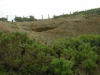
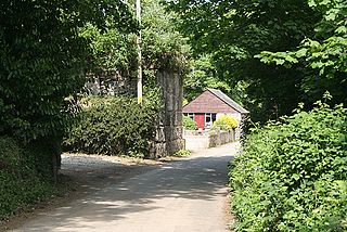
Penberthy Croft Mine, is a disused mine and Site of Special Scientific Interest (SSSI) in Cornwall, England, UK. It is located to the north of the civil parish of St Hilary, 5 miles (8.0 km) east of the town of Penzance.

Croft is a village and former civil parish, now in the parish of Croft and Yarpole, in north Herefordshire, England. In 1961 the parish had a population of 25. On 1 April 1987 the parish was abolished and merged with Yarpole to form "Croft & Yarpole".

Watch Croft is a prominent hill, 252 metres (827 ft) high overlooking the north coast of Cornwall, UK. Its prominence of 225 metres qualifies it as a Marilyn, one of only five in Cornwall. The others are Brown Willy, Kit Hill, Hensbarrow Beacon and Carnmenellis. It is the highest point in West Penwith.
Newlyn and Goonhavern was an electoral division of Cornwall in the United Kingdom and returned one member to sit on Cornwall Council. It was abolished in 2021.
