
Saunderton is a village and former civil parish, now in the parish of Bledlow-cum-Saunderton, Buckinghamshire, England. It is in the Saunderton Valley in the Chiltern Hills, the village consists of three main areas: a linear settlement along Bledlow Road about 1+1⁄4 miles (2 km) southwest of Princes Risborough, Saunderton Lee, about 1+1⁄2 miles (2 km) further south and a residential area on the A4010 road around Saunderton railway station, about 4+1⁄2 miles (7 km) northwest of High Wycombe. This residential area, unlike the other two parts of the village, is in the HP14 postcode district, meaning its post town is High Wycombe, not Princes Risborough, the boundary between the two post towns passing just south of Grange Farm. In 1931 the parish had a population of 454.

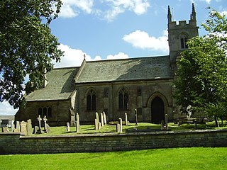
Howell is a village in the civil parish of Asgarby and Howell, in the North Kesteven district of Lincolnshire, England, approximately 1 mile (1.6 km) north of the A17, 4 miles (6 km) east from Sleaford, and 1.5 miles (2.4 km) north from Heckington. In 1921 the parish had a population of 58.

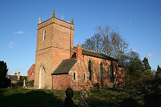
Althorpe is a small village and former civil parish, now in the parish of Keadby with Althorpe, in the North Lincolnshire district, in the ceremonial county of Lincolnshire, England. It is four miles (6 km) west of Scunthorpe and the same distance south-east of Crowle, on the A18 road.

Asgarby is a village in the civil parish of Asgarby and Howell, in the North Kesteven district of Lincolnshire, England. It is situated on the A17 Boston to Newark road, 3 miles (5 km) east from Sleaford and 2 miles (3 km) north-west from Heckington. In 1921 the parish had a population of 63. On 1 April 1931 the parish was abolished to form "Asgarby and Howell".

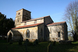
Bag Enderby is a village and former civil parish, now in the parish of Greetham with Somersby, in the East Lindsey district of Lincolnshire, England. It lies just north of the A158 road, 6 miles (10 km) north-east from Horncastle and 4 miles (6 km) north-west from Partney. In 1931 the parish had a population of 29. On 1 April 1936 the parish was abolished and merged with Somersby.
Gunby is a village and former civil parish, now in the parish of Gunby and Stainby, in the South Kesteven district of Lincolnshire, England. It is situated close to the borders with Leicestershire and Rutland, and 9 miles (14 km) south from Grantham, and 2 miles (3 km) west from the A1 road. In 1921 the parish had a population of 119. On 1 April 1931 the parish was abolished and merged with Stainby to form "Gunby and Stainby".

Sapperton is a village in the civil parish of Braceby and Sapperton, in the South Kesteven district of Lincolnshire, England. The nearest town is Grantham, 6 miles (9.7 km) to the west. Adjacent villages include Braceby, Pickworth and Ropsley. In 1921 the parish had a population of 46. On 1 April 1931 the parish was abolished and merged with Braceby to form "Braceby and Sapperton".

Creeton is a village in the civil parish of Counthorpe and Creeton in the South Kesteven district of Lincolnshire, England. It is situated 3 miles (5 km) south west from Bourne and 3 miles (4.8 km) south from Corby Glen, on the River Glen. In 1921 the parish had a population of 72. On 1 April 1931 the parish was abolished and merged with Counthorpe to form "Counthorpe and Creeton".

Old Woodhall or Woodhall, is a village and former civil parish, now in the parish of Stixwould and Woodhall, in the East Lindsey district, in the county of Lincolnshire, England. It is located about 3 miles (4.8 km) south west of Horncastle. In 1961 the parish had a population of 123.

Edlington is a village in the parish of Edlington with Wispington, in East Lindsey Lincolnshire, England. It is situated 2 miles (3.2 km) north-west of Horncastle. In 1961 the parish had a population of 105. On 1 April 1987 the parish was abolished and merged with Wispington to form Edlington with Wispington.

Grainsby is a hamlet and civil parish in the East Lindsey district of Lincolnshire, England. It is situated 5 miles (8 km) south from Grimsby, and just to the west from the A16 road. The nearest village is North Thoresby, 1 mile (1.6 km) to the south-east.

East Keal is a village and civil parish in the East Lindsey district of Lincolnshire, England. It is situated approximately 13 miles (21 km) north from the town of Boston, 2 miles (3 km) south from the town of Spilsby, and on the edge of the Lincolnshire Wolds, an Area of Outstanding Natural Beauty.
Candlesby is a village and former civil parish, now in the parish of Candlesby with Gunby, in the East Lindsey district of Lincolnshire, England. It is situated 5 miles (8 km) east from Spilsby. Gunby is a hamlet about 1 mile (1.6 km) east from Candlesby. In 1961 the parish had a population of 144.

Ruckland is a village in the civil parish of Maidenwell, and about 6 miles (10 km) south from the town of Louth, in the East Lindsey district, in the county of Lincolnshire, England. It lies in the Lincolnshire Wolds, a designated Area of Outstanding Natural Beauty. In 1931 the parish had a population of 21. On 1 April 1936 the parish was abolished to form Maidenwell.

Londonthorpe is a village in the civil parish of Londonthorpe and Harrowby Without, in South Kesteven district of Lincolnshire, England. It lies 3 miles (5 km) to the north-east from Grantham, 1 mile (1.6 km) to the west from the B6403, and borders Belton Park in the west.

Doddington is a village in the civil parish of Doddington and Whisby, in the North Kesteven district of Lincolnshire, England. The population of the civil parish of "Doddington and Whisby" at the 2011 census was 319. The parish of Doddington and Whisby lies 5 miles (8 km) west of Lincoln, to the north of the A46 road, and is bounded to its west by Nottinghamshire. It includes the hamlet of Whisby, and parts of the Whisby Moor Nature Reserve.

Haceby is a village in the civil parish of Newton and Haceby in the district of North Kesteven, Lincolnshire, England. It is 8 miles (13 km) east from Grantham, 8 miles south from Sleaford, and 1 mile (1.6 km) south from the A52 road. In 1921 the parish had a population of 51. On 1 April 1931 the parish was abolished and merged with Newton to form "Newton and Haceby".
Kingerby is a village and former civil parish, now in the parish of Osgodby, in the West Lindsey district of Lincolnshire, England. It is situated 5 miles (8.0 km) north west from the town of Market Rasen. The hamlet of Bishop Bridge lies about 1.5 miles (2.4 km) to the south-west. In 1931 the parish had a population of 75. On 1 April 1936 the parish was abolished to form Osgodby.

South Reston is a village in the civil parish of Reston, in the East Lindsey district of Lincolnshire, England. It is situated on the A157 road 5 miles (8.0 km) south-east from the town of Louth.

Spanby is a village and former civil parish, now in the parish of Threekingham, in the North Kesteven district of Lincolnshire, England, about 5 miles (8 km) south from the town of Sleaford. In 1921 the parish had a population of 84. On 1 April 1931 the parish was abolished and merged with Threekingham.

