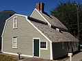
The House of the Seven Gables is a 1668 colonial mansion in Salem, Massachusetts, named for its gables. It was made famous by Nathaniel Hawthorne's 1851 novel The House of the Seven Gables. The house is now a non-profit museum, with an admission fee charged for tours, as well as an active settlement house with programs for the local immigrant community including ESL and citizenship classes. It was built for Captain John Turner and stayed with the family for three generations.

The Salem Maritime National Historic Site is a National Historic Site consisting of 12 historic structures, one replica tall-ship, and about 9 acres of land along the waterfront of Salem Harbor in Salem, Massachusetts, United States. Salem Maritime is the first National Historic Site established in the United States. It interprets the Triangle Trade during the colonial period, in cotton, rum, sugar and slaves; the actions of privateers during the American Revolution; and global maritime trade with the Far East, after independence. The National Park Service manages both the National Historic Site and a Regional Visitor Center in downtown Salem. The National Park Service (NPS) is an agency of the United States Department of the Interior.

The Cambridge Common Historic District is a historic district encompassing one of the oldest parts of Cambridge, Massachusetts. It is centered on the Cambridge Common, which was a center of civic activity in Cambridge after its founding in 1631. It was the site of the election for governor of the Massachusetts Bay Colony in 1636, and was a military barracks site during the American Revolutionary War. The common was gradually reduced in size to its present roughly triangular shape, and surrounded by buildings in the 18th and 19th centuries. In 1973 a historic district encompassing the extant common and everything within 100 feet (30 m) of it was listed on the National Register of Historic Places. In 1987 the district was amended to rationalize the boundary, which overlapped adjacent districts and included portions of some buildings.

The Beverly Center Business District encompasses much of the historic 19th century commercial heart of Beverly, Massachusetts. Centered on Cabot and Church Streets between Central Street and the Beverly Common, its architecture reflects the city's growth over 150 years. The district was added to the National Register of Historic Places in 1984.

The Salem Village Historic District encompasses a collection of properties from the early center of Salem Village, as Danvers, Massachusetts was known in the 17th century. The district includes an irregular pattern of properties along Centre, Hobart, Ingersoll, and Collins Streets, as far north as Brentwood Circle, and south to Mello Parkway. It includes several buildings notable for their association with the 1692 Salem witch trials, which were mostly centered on individuals who lived in Salem Village. Included in the village are the Rebecca Nurse Homestead, now a house museum, and the remains of the local parsonage, both places of relevance to the witch hysteria.

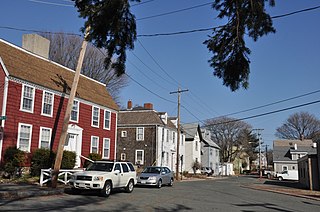
The Bridge Street Neck Historic District is a predominantly residential historic district in Salem, Massachusetts. It encompasses most of a peninsula of land northeast of downtown Salem, on the route connecting Salem to Beverly, which has been the scene of residential, commercial, and industrial development since the early settlement of Salem in the 1630s. Bridge Street, the spine of the district is a thoroughfare connecting Salem to the bridge leading to Beverly. The district is roughly bounded by railroad tracks to its west, the shore of the peninsula to the east, On the north it is bounded by modern (post-1952) developments, and on the south it abuts the Salem Common Historic District. In addition to properties on Bridge Street, the district includes properties on side streets between March/Osgood Streets, and Howard/Webb Streets. It was listed on the National Register of Historic Places in 2002.

The Central Street District is a historic district encompassing the traditional heart of Andover, Massachusetts prior to the development in the later 19th century of the current town center. It consists mainly of residential and religious properties along Central Street, from Phillips Street in the south to Essex Street in the north. All of the listed properties have frontage on Central Street, even if their addresses are on one of the adjacent streets.

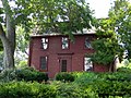
The Charter Street Historic District encompasses a small remnant of the oldest part of Salem, Massachusetts that has since been surrounded by more modern development. It includes three properties on Charter Street: the Pickman House, the Grimshawe House, and the Charter Street Cemetery, or Central Burying Point. The district was listed on the National Register of Historic Places in 1975.
The Crombie Street District in Salem, Massachusetts encompasses a small residential enclave in a now urbanized part of central Salem. It consists of seven houses and one church, located at 7-15 and 16-18 Crombie St., and 13 Barton Street. The district was listed on the National Register of Historic Places in 1983.
Downtown Salem District is a historic district roughly bounded by Church, Central, New Derby, and Washington Streets in Salem, Massachusetts. It was added to the National Register of Historic Places in 1983, and represents a major expansion of the Old Town Hall Historic District, which was listed in 1972.

The Federal Street District is a residential and civic historic district in Salem, Massachusetts, United States. It is an expansion of an earlier listing of the Essex County Court Buildings on the National Register of Historic Places in 1976. In addition to the former county court buildings included in the earlier listing, the district expansion in 1983 encompasses the entire block of Federal Street between Washington and North Streets. It includes buildings from 32 to 65 Federal Street, as well as the Tabernacle Church at 50 Washington Street.
The Fish Flake Hill Historic District encompasses a section of Front Street in Beverly, Massachusetts that includes a remarkable concentration of colonial buildings, and which was notable for its importance in the American Revolutionary War. The district, which was listed on the National Register of Historic Places in 1971, includes properties on both sides of Front Street between Cabot and Bartlett Streets. It includes houses dating to the middle 18th century, sixteen of which have been documented as being associated with ship captains active in the American Revolutionary War. The port area of Beverly was one of the most active during the war, and was one of the places where many captured ships were brought.
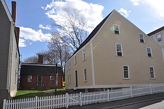
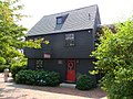
The Gedney and Cox Houses are historic houses at 21 High Street in Salem, Massachusetts. The earliest part of the Gedney House was built c. 1665, and the houses were added to the National Register of Historic Places in 1974. They are owned by Historic New England, which offers limited tours.
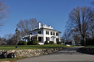
Beebe Homestead, also known as the Lucius Beebe House and Beebe Farm, is a historic Federal period home at 142 Main Street in Wakefield, Massachusetts, which was built during the federal era that extended from the late 18th-century into the 1820s. It is suspected to have been remodeled into the federal style from an earlier home built in circa 1727. It overlooks Lake Quannapowitt, and according to a 1989 study of historic sites in Wakefield, the house is "one of Wakefield's most imposing landmarks." The property was added to the National Register of Historic Places in 1989.

The Front Street Historic District in Exeter, New Hampshire, encompasses a portion of the town's historic center. The district extends from Swasey Pavilion, at the junction of Front and Water streets, southwesterly along Front Street to Gale Park, about five blocks. Front Street is one of Exeter's oldest roads, and is lined with a series of 18th and 19th-century civic, religious, and residential structures, many of which are well preserved. The district was listed on the National Register of Historic Places (NRHP) in 1973.

The Hollis Village Historic District encompasses the historic village center of Hollis, New Hampshire. The district is centered on Monument Square, which connects Main Street to Depot Street and Broad Street. It covers about 400 acres (160 ha), and extends along all three of those roads for some distance, and includes properties on Silver Lake Road and Ash Street. Most of the buildings in the district are residential or agricultural in use, and date before the turn of the 20th century; the oldest buildings date to the mid-18th century. The "Always Ready Engine House", which occupies a triangular parcel at the western end of Monument Square, was built in 1859, and is the town's oldest municipal building. Its most architecturally sophisticated building is the town hall, built in 1887 to a design by William M. Butterfield of Manchester. The district represents the growth of a mainly agricultural community over a 200-year period. The district was listed on the National Register of Historic Places in 2001.
This is a timeline of the history of the city of Salem, Massachusetts, United States.

The Squire Cheyney Farm is an historic, American farm and national historic district that is located in Thornbury Township, Chester County, Pennsylvania.

The Winthrop Center/Metcalf Square Historic District encompasses the historic center of the city of Winthrop, Massachusetts. Although the area was settled early in Massachusetts history, the Winthrop peninsula remained sparsely populated until the 19th century. Its central area did not begin significant development until there was some industrial development in the first half of the 19th century, and accelerated with the arrival of the railroad later in the 19th century. It is centered on Metcalf Square, at the junction of Pauline, Hermon, and Winthrop Streets; the district extends northward along Hermon and Winthrop, and also includes properties as far east as Cross Street.

The Exeter Waterfront Commercial Historic District encompasses the historic commercial and residential waterfront areas of Exeter, New Hampshire. The district extends along the north side of Water Street, roughly from Main Street to Front Street, and then along both sides of Water and High streets to the latter's junction with Portsmouth Street. It also includes properties on Chestnut Street on the north side of the Squamscott River. This area was where the early settlement of Exeter took place in 1638, and soon developed as a shipbuilding center. The district was listed on the National Register of Historic Places in 1980. It was enlarged in 1986 to include the mill complex of the Exeter Manufacturing Company on Chestnut Street.