
The Murrumbidgee River is a major tributary of the Murray River within the Murray–Darling basin and the second longest river in Australia. It flows through the Australian state of New South Wales and the Australian Capital Territory, descending 1,500 metres (4,900 ft) over 1,485 kilometres (923 mi), generally in a west-northwesterly direction from the foot of Peppercorn Hill in the Fiery Range of the Snowy Mountains towards its confluence with the Murray River near Boundary Bend.
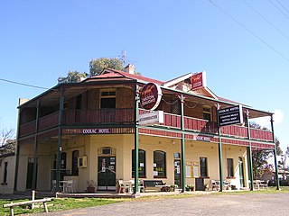
Coolac is a village in the Riverina region of New South Wales, Australia in Gundagai Council. At the 2016 census, Coolac had a population of 216.
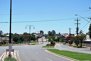
Coolamon is a town in the Riverina region of south-west New South Wales, Australia. Coolamon is 40 kilometres (25 mi) north-west of Wagga Wagga and 506 kilometres (314 mi) south-west of Sydney via the Hume and Sturt Highways. The town is situated on the railway line between Junee and Narrandera. Coolamon had a population of 2,199 at the 2016 census and is 290 metres (950 ft) above sea level. It is the administrative and service centre for the local government area which bears its name—Coolamon Shire.

Collingullie is a village 26 kilometres (16 mi) north-west of Wagga Wagga in the Riverina region of New South Wales, Australia. The village is located on the Sturt Highway, between Wagga Wagga and Narrandera, at the crossroads with the road to Lockhart.
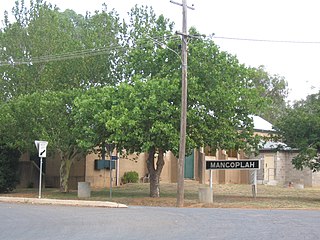
Mangoplah is a town approximately 36 kilometres (22 mi) south of Wagga Wagga in the Riverina region of New South Wales, Australia. At the 2016 census, Mangoplah had a population of 309. The name of the town is believed to mean "Kooris singing" in the Wiradjuri aboriginal language.

City of Wagga Wagga is a local government area in the Riverina region of southern New South Wales, Australia.

Ganmain is a town in the Riverina region of New South Wales, Australia. Ganmain is located around 55 kilometres (34 mi) north west of Wagga Wagga, and 50 kilometres (31 mi) east of Narrandera. Ganmain is in the Coolamon Shire local government area and had a population at the 2016 census of 779.

Downside is a farming community in the central east part of the Riverina and situated about 15 kilometres north west from Wagga Wagga and 24 kilometres south east from Coolamon.

Rosewood is a village community and locality in the south east part of the Riverina, New South Wales, Australia. It is situated about 16 kilometres (9.9 mi) south east from Carabost and 19 kilometres (12 mi) north west from Tumbarumba. At the 2016 census, Rosewood had a population of 214. The village is administered by two local governments; the northern part of the locality by the Greater Hume Shire and the southern part of the locality by the Snowy Valleys Council. The village of Rosewood is within the Snowy Valleys Council area.
Alfredtown is a rural community in the central east part of the Riverina. It is about 5 km north of Ladysmith and 14 km east of Wagga Wagga.

Ashmont, known originally as "J.J. Salmon's Estate" is a south-western suburb of Wagga Wagga, New South Wales, Australia. The suburb is named after the Salmon family's original homestead that was located where the suburb now stands.
Kapooka is a suburb in the south-west of Wagga Wagga, New South Wales, Australia.
Gregadoo is a suburb of Wagga Wagga situated about 6 km South South-East of Lake Albert, New South Wales, Australia. It is situated by road, about 9 kilometres south east from Wagga Wagga.

East Wagga Wagga is a suburb of Wagga Wagga, New South Wales. East Wagga Wagga is mostly an industrial area located approximately 3 km (2 mi) east south-east of the central business district on the Sturt Highway. Home Base Wagga Wagga, WIN Television, Country Energy depot, Riverina Water County Council headquarters, Australia Post Mail Sorting Centre, Busabout Wagga Wagga depot, Australian Clay Target Association (ACTA) National Office and ACTA shooting range are located within East Wagga Wagga.

Charles Sturt University is a suburb and location for Charles Sturt University's Wagga Wagga Campus is located in the suburb of Estella.

Eunanoreenya is a rural suburb of Wagga Wagga, New South Wales.

The Gap is a farming community in the central east part of the Riverina close to Wagga Wagga.
Gobbagombalin is a predominantly farming community in the central east part of the Riverina and a suburb of Wagga Wagga. A portion of Gobbagombalin adjacent to the suburb of Estella and to the North of Old Narrandera Road was rezoned for residential purposes under the Wagga Wagga Local Environmental Plan 2010 in July 2010, with suburban development of area commencing in 2013. The suburban part of Gobbagombalin is being marketed under various names including Estella Rise and Estella Heights, as well as Gobbagombalin, despite Estella being a separate locality further to the east of Gobbagombalin.

CountryMinded was an Australian political party between 2014 and 2018 that claimed to represent the interests of regional Australians whose livelihoods depend either directly or indirectly on agricultural production. The party was founded in December 2014 by a group of people looking for accountable regional representation, including two brothers from New South Wales, David and Peter Mailler as the Country Party of Australia, and changed its name to CountryMinded in September 2015. In 2018, the party merged with the Australian Democrats.

