
The Glebe is a neighbourhood in Ottawa, Ontario, Canada. It is located just south of Ottawa's downtown area in the Capital Ward. According to the Glebe Community Association, the neighbourhood is bounded on the north by the Queensway, on the east and south by the Rideau Canal and on the west by LeBreton Street South, Carling Avenue and Dow's Lake. As of 2016, this area had a population of 13,055. This area includes the Glebe Annex, an area west of Bronson Avenue that maintains its own neighbourhood association.

The West End is a neighbourhood in Vancouver, British Columbia, Canada on the Downtown Vancouver peninsula neighbouring Stanley Park and the areas of Yaletown, Coal Harbour and the financial and central business districts.

Kitsilano is a neighbourhood located in the city of Vancouver, British Columbia, Canada. Kitsilano is named after Squamish Chief August Jack Khatsahlano, and the neighborhood is located in Vancouver's West Side along the south shore of English Bay, between the neighborhoods of West Point Grey and Fairview.
Kerrisdale is a neighbourhood in the city of Vancouver, British Columbia, Canada.

The Vancouver School Board is a school district based in Vancouver, British Columbia, Canada. A board of nine trustees normally manages this district that serves the city of Vancouver and the University Endowment Lands.
There are various neighbourhoods within the city of Charlottetown, Prince Edward Island.

Marpole, originally a Musqueam village named c̓əsnaʔəm, is a mostly residential neighbourhood of 23,832 in 2011, located on the southern edge of the city of Vancouver, British Columbia, immediately northeast of Vancouver International Airport. It is approximately bordered by Angus Drive to the west, 57th Avenue to the north, Fraser Street to the east and the Fraser River to the south. It has undergone many changes in the 20th century, with the influx of traffic and development associated with the construction of the Oak Street Bridge and the Arthur Laing Bridge.

Arbutus Ridge is an affluent residential neighbourhood in Vancouver's West Side. It is bordered by 16th Avenue in the north, 41st Avenue in the south, Mackenzie Street in the west, and East Boulevard in the east. The neighbourhood is characterized by larger than average lot sizes, with stately homes on tree-lined streets.
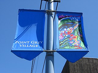
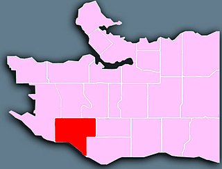
West Point Grey is a neighbourhood in the northwest of the city of Vancouver, British Columbia, Canada. It is located on Point Grey and is bordered by 16th Avenue to the south, Alma Street to the east, English Bay to the north, and Blanca Street to the west. Notable beaches within the West Point Grey boundary include Spanish Banks, Locarno and Jericho. Immediately to the south is Pacific Spirit Regional Park and to the east is Kitsilano.

Fairview is a neighbourhood on the west side of the city of Vancouver, British Columbia, Canada. It runs from 16th Avenue in the south, to Burrard Street in the west, to Cambie Street in the east, and to False Creek in the north.

East Vancouver is a region within the city of Vancouver, British Columbia, Canada. Geographically, East Vancouver is bordered to the north by Burrard Inlet, to the south by the Fraser River, and to the east by the city of Burnaby. East Vancouver is divided from Vancouver's "West Side" by Ontario St.

Renfrew–Collingwood is a large neighbourhood that lies on the eastern side of Vancouver, British Columbia, Canada, on its boundary with Burnaby and encompassing an area that was one of the earlier developed regions of the city. It is a diverse area that includes a substantial business community in several areas, as well as some of the fastest-growing residential sectors of Vancouver. In 2011, the neighbourhood had a population of 50,500, 38.4% of whom claim Chinese as their first language.

Shaughnessy is an almost-entirely residential neighbourhood in Vancouver, British Columbia, Canada, spanning about 447 hectares in a relatively central locale. It is bordered by 16th Avenue to the north, 41st Avenue to the south, Oak Street to the east, and East Boulevard to the west. The older section of the neighbourhood, called "First Shaughnessy," is considered more prestigious and is bordered by 16th Avenue to the north, King Edward Avenue to the south, Oak Street to the east, and East Boulevard to the west. In 2011, the population was approximately 8,807. It was named after Thomas Shaughnessy, 1st Baron Shaughnessy, former president of the Canadian Pacific Railway.

Glen Park is a neighbourhood in the city of Toronto, Ontario, Canada, located in the district of North York. It is bounded by Lawrence Avenue to the north, Bathurst Street to the east, a line south of Stayner Avenue to the south, and the CNR tracks to the west. Prior to the amalgamation of Metropolitan Toronto in 1998, it was part of the city of North York. It is also included as part of the larger official Yorkdale-Glen Park neighbourhood.
Fairfield is a neighbourhood of Victoria, British Columbia. It is bounded by the James Bay, Downtown, Harris Green, Fernwood, Rockland, and Gonzales neighbourhoods, and meets the Strait of Juan de Fuca to the south.
Windsor Way is a special community street that links four parks and three elementary schools as well as a bike path in East Vancouver, Canada, which was identified as a local Greenway in the Kensington-Cedar Cottage Visioning process. As there was no funding available to turn the many blocks of this street into a local Greenway, the local community worked with the City of Vancouver planning department to implement a demonstration project called "Blooming Boulevards". This demonstration project allowed residents to garden the frontages of their yards between the street and the sidewalk. This section of street contains the wires and ducts of the city, and this was the first time that gardening on these city owned frontages was allowed. The program was so successful that Blooming Boulevards are now city policy and boulevards are now gardened throughout the city.

Varsity is an established neighbourhood in the Northwest quadrant of Calgary, Alberta. It was developed in the 1960s and early 1970s on a plateau to the north of the Bow River valley, and is primarily composed of Single-detached dwellings on wide lots. The neighbourhood comprises three major areas: Varsity Acres, Varsity Village, and Varsity Estates. Varsity is bounded on the north and east by Crowchild Trail, on the west by the Bow River, and on the south by 32nd Avenue NW. It borders the neighbourhoods of Silver Springs and Bowness on the west side, and both Montgomery and the University of Calgary campus on the south side. The easternmost portion of Varsity contains the University of Calgary Research Park.

The Sports Complex Special Services District (SCSSD)is a 501(c)(3) non-profit organization in Philadelphia that was established in the year 2002 to minimize the impact of concentrating major sporting and entertainment facilities in a geographic area adjacent to established Philadelphia residential neighborhoods of South Philadelphia.
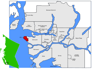
The University Endowment Lands (UEL) is an unincorporated area that lies to the west of the city of Vancouver, British Columbia, Canada, and adjacent to the University of British Columbia and the lands associated with that campus. Pacific Spirit Regional Park lies within the UEL. The UEL is part of Metro Vancouver. Mail sent to the UEL is addressed to "Vancouver" rather than the UEL.

Runnymede is a neighbourhood in Toronto, Ontario, Canada located north of Bloor Street West between Jane Street and Runnymede Road north to Dundas Street West. It is located directly north of the former village of Swansea and west of the High Park North neighbourhood. The immediate area around Bloor Street is commonly known as Bloor West Village after the shopping area along Bloor Street, whereas the area to the north is considered the Runnymede neighbourhood.

