
The East Blackstone Village Historic District is a historic district roughly along Elm Street at the junction with Summer Street in eastern Blackstone, Massachusetts. It encompasses a small 19th-century mill village center that developed along what was once a major roadway connecting Worcester with Providence, Rhode Island. The district was added to the National Register of Historic Places in 1995.
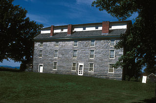
The Brownington Village Historic District is a historic site in Brownington, Vermont, United States. It is located near the intersection of Hinman and Brownington Center roads. It was added to the U.S. National Register of Historic Places on June 9, 1973. The district consists of five buildings within the Old Stone House Museum complex and three neighboring houses, dating from the early 19th century.

The Central New Bedford Historic District is one of nine historic districts in New Bedford, Massachusetts, United States. The district encompasses the city's central business district, built up during the time in the late 19th century when textiles had replaced whaling as the city's main industry. It is a 29-acre (12 ha) rectangular area bounded by Acushnet Avenue and the older New Bedford Historic District on the east, School Street to the south, Middle Street on the north and 6th Street in the west. It was added to the National Register of Historic Places in 1980.

The Wellfleet Center Historic District is a historic district in Wellfleet, Massachusetts. It encompasses resources that exemplify the development of the community, beginning in the late 18th century, as a thriving commercial maritime center, and then its rise as a summer resort community in the late 19th century. Buildings in the district include Cape-style houses from the mid-18th century, 19th century commercial and institutional buildings in the town center, and the 1880s summer estate of Lorenzo Dow Baker. The district is roughly bounded by Cross St., Holbrook Ave., Main, E. Main and School Streets, and Duck Creek, and was listed on the National Register of Historic Places in 1989.

Old Curtisville Historic District encompasses the village center of Interlaken in Stockbridge, Massachusetts. It is historically significant as the site of the first wood-based newsprint paper mill in the United States, and has a well-preserved collection of late 18th and early 19th-century architecture. It was listed on the National Register of Historic Places in 1976.

The Park Square Historic District is a historic district in Pittsfield, Massachusetts. The district is centered on the historic heart of Pittsfield encompassing a number city blocks adjacent to Park Square, which is at the junction of North, South, East, and West Streets.

The Sheffield Plain Historic District encompasses the original 18th-century village center of Sheffield, Massachusetts, United States. The linear district extends southward about 0.5 miles (0.80 km) from the junction of United States Route 7 and Cook Road, where the original town common is located. The district was primarily developed in the mid-18th and early 19th centuries. It was listed on the National Register of Historic Places in 1988.

The South Egremont Village Historic District encompasses most of the village of South Egremont, Massachusetts, a well-preserved village whose architecture has seen relatively little alteration since the 1840s. It is located along Massachusetts Route 23 in the plains east of the Taconic Mountains. The district was listed on the National Register of Historic Places in 1984.
The South School is a historic school building in Stoneham, Massachusetts. It is the best preserved 19th century schoolhouse in Stoneham. The two-story wood-frame building housed two classrooms on each of its two floors, and was built c. 1857–58, at a time when many schoolhouses in the state were typically single story buildings with one or two classrooms. The building saw academic use well into the 20th century before being converted to other uses. It has retained its basic form, as well exterior Italianate features.

The Woodbridge Street Historic District is a predominantly residential historic district in South Hadley, Massachusetts, United States. It extends from the junction of Woodbridge Street and Silver Street north roughly to Woodbridge Terrace. This area was one of the first to be settled in South Hadley, and includes its oldest buildings, which date to the 1720s. It also has the community's highest concentration of high-quality 18th-century residential architecture. It was listed on the National Register of Historic Places in 1983.

The South Worthington Historic District is a historic district encompassing the formerly industrial, but now rural, village of South Worthington, Massachusetts. The village is centered on the junction of Huntington Road, Ireland Street, and Thrasher Hill Road. The district extends along Ireland Road as far as Conwell Road, and one contributing element, the dam which impounds Little Galilee Pond, extends into neighboring Chesterfield. The area had a number of small mills along the banks of the Little River, a tributary of the Westfield River, but only one complex, the Theron Higgins Mill on South Worthington Road, has survived from the 19th century. Most of the buildings in the district are residences dating to the 19th century; also included are three churches, including the particularly elegant Greek Revival South Worthington Methodist Church (1848). The district was added to the National Register of Historic Places in 2005.
The Ballardvale District in Andover, Massachusetts, encompasses the historic mill village of Ballardvale in the northwestern part of the town. It is centered on the crossing the Shawsheen River by Andover Street, and includes buildings on High Street, Center Street, and other adjacent roads on both sides of the river. The district was listed on the National Register of Historic Places in 1982.

The Palmer School, also known as the District No. 2 Schoolhouse, is a historic 19th-century one-room schoolhouse at 33 Main Street in Boxford, Massachusetts. Built in 1845, it is the town's last surviving 19th-century school building. It was used as a school until 1931, replaced by the Cole School, on whose grounds it stands. The building was listed on the National Register of Historic Places in 1998.

The Common Historic District is a historic district encompassing the civic and institutional heart of Reading, Massachusetts. The district is centered on the town common, at the intersection of Main and Salem Streets. The common has been communally owned since at least 1737, with the original burying ground to the north. In 1769 the area's first meeting house was built, giving the area a sense of identity separate from portions of Reading that would later be set off as Wakefield and North Reading. Since then the area has become a focal point for religious and civic institutions in the town.

The Common District encompasses the main civic center of Wakefield, Massachusetts. It is centered on the historic town common, just south of Lake Quannapowitt, which was laid in 1644, when it became the heart of Old Reading. The area was separated from Reading as South Reading in 1818, and renamed Wakefield in 1868. The 25 acre district includes the buildings that line the common on Common Street and Main Street, which include the town hall, public library, YMCA, post office, and several churches. It was listed on the National Register of Historic Places in 1990.

The Westfield Center Historic District is a historic district encompassing 157 acres (64 ha) of the civic, commercial, and industrial heart of Westfield, Massachusetts. It represents a major expansion of the Westfield Center Commercial Historic District, which included only two blocks of buildings along Elm Street in downtown Westfield. The district includes buildings representing the city's growth in the 19th century as a center of the whip-making industry, and its early years as a center for statewide educational institutions, as well as its growth as a regional center of western Hampden County. The commercial district was added to the National Register of Historic Places in 2008; the expansion and renaming of the district took place in 2013.

The Smith's Corner Historic District is a historic district encompassing a historic 19th-century rural village center. Covering about 105.5 acres (42.7 ha), the district is centered on the junction of Main Avenue, South Road, and Chase Road in northwestern South Hampton, abutting its border with East Kingston. The village was important as a stagecoach stop. The district was listed on the National Register of Historic Places in 1983.

Mount Vernon Triangle is a neighborhood and community improvement district in the northwest quadrant of Washington, D.C. The neighborhood is located adjacent to Mount Vernon Square. Originally a working-class neighborhood established in the 19th century, present-day Mount Vernon Triangle experienced a decline in the mid-20th century as it transitioned from residential to commercial and industrial use.

The Randolph Center Historic District encompasses the historic early town center of Randolph, Vermont. Established in 1783, it was later eclipsed by Randolph Village, which developed around the town's main railroad depot. The village now has a distinguished array of late 18th and early 19th-century architecture, and is home to an academic campus now housing Vermont State University. It was listed on the National Register of Historic Places in 1974.
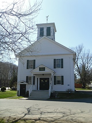
The Gill Center Historic District encompasses the historic 19th-century village center of Gill, Massachusetts. The district is focused on Main Road near its junction with River Road, in the central northern part of the town, and has served as the community's center since its incorporation in 1793. The district was listed on the National Register of Historic Places in 1999; it features a variety of mainly Greek Revival and later Victorian architecture, as well as some 20th-century Colonial Revival buildings.


