Before the independence of South Sudan from Sudan, the 10 states of Southern Sudan were divided into districts. These districts have been superseded by counties.
Before the independence of South Sudan from Sudan, the 10 states of Southern Sudan were divided into districts. These districts have been superseded by counties.


| Wikimedia Commons has media related to maps of districts in Sudan . |

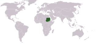
Sudan, officially the Republic of the Sudan, is a country in Northeast Africa. It borders the countries of Central African Republic, Chad, Egypt, Eritrea, Ethiopia, Libya, South Sudan, and the Red Sea. It has a population of 44.91 million people as of 2021 and occupies 1,886,068 square kilometres, making it Africa's third-largest country by area, and the third-largest by area in the Arab League. It was the largest country by area in Africa and the Arab League until the secession of South Sudan in 2011, since which both titles have been held by Algeria. Its capital is Khartoum and its most populated city is Omdurman.
Currently, the politics of Sudan takes place in the framework of a federal provisional government. Previously, a President was head of state, head of government, and commander-in-chief of the Sudanese Armed Forces in a de jure multi-party system. Legislative power was officially vested in both the government and in the two chambers, the National Assembly (lower) and the Council of States (higher), of the bicameral National Legislature. The judiciary is independent and obtained by the Constitutional Court. However, following a deadly civil war and the still ongoing genocide in Darfur, Sudan was widely recognized as a totalitarian state where all effective political power was held by President Omar al-Bashir and his National Congress Party (NCP). However, al-Bashir and the NCP were ousted in a military coup which occurred on April 11, 2019. The government of Sudan was then led by the "Transitional Military Council" or TMC. On 20 August 2019, the TMC dissolved giving its authority over to the Sovereignty Council of Sudan, who were planned to govern for 39 months until 2022, in the process of transitioning to democracy. However, the Sovereignty Council and the Sudanese government were dissolved in October 2021.

al-Nahr, was a Palestinian village 14 km (8.7 mi) northeast of Acre. It was depopulated in May 1948 after a military assault carried out by the Carmeli Brigade as part of the Israel Defense Forces's Operation Ben-Ami. Immediately after the assault, the village of al-Nahr was razed.

Below is a list of the 18 states of Sudan, organized by their original provinces during the period of Anglo-Egyptian Sudan. Arabic language versions are, as appropriate, in parentheses. Prior to 9 July 2011, the Republic of Sudan was composed of 25 states. The ten southern states now form part of the independent country of South Sudan. Two additional states were created in 2012 within the Darfur region, and one in 2013 in Kordofan, bringing the total to 18.
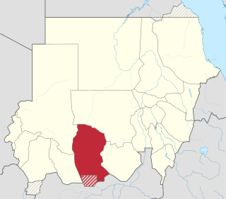
West Kordofan is one of the 18 wilayat or provinces of Sudan. In 2006 it had an area of 111,373 km² and an estimated population of approximately 1,320,405. Al-Fulah is the capital of the state.
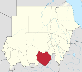
South Kordofan is one of the 18 wilayat or states of Sudan. It has an area of 158,355 km² and an estimated population of approximately 1,100,000 people (2000). Kaduqli is the capital of the state. It is centered on the Nuba Hills. At one time it was supposed that South Kordofan was the only state in (North) Sudan suitable for producing oil, but oil has also been discovered in neighboring White Nile State in larger quantities.

River Nile is one of the 18 wilayat or states of Sudan. It has an area of 122,123 km² (47,152 mi²) and an estimated population of 1,027,534 (2006). It is made up of seven localities.

The Atbarah River, also known as the Black Nile, is a river in northeast Africa. It rises in northwest Ethiopia, approximately 50 km north of Lake Tana and 30 km west of Gondar. It then flows about 805 km (500 mi) to the Nile in north-central Sudan, joining it at the city of Atbarah. The river's tributary, the Tekezé (Setit) River, is perhaps the true upper course of the Atbarah, as the Tekezé follows the longer course prior to the confluence of the two rivers in northeastern Sudan. The Atbarah is the last tributary of the Nile before it reaches the Mediterranean.
Southern Lebanon is the area of Lebanon comprising the South Governorate and the Nabatiye Governorate. The two entities were divided from the same province in the early 1990s. The Rashaya and Western Beqaa Districts, the southernmost districts of the Beqaa Governorate, in Southern Lebanon are sometimes included.
Before the independence of South Sudan, the States of Sudan were subdivided into 133 districts. With the adoption of the Interim National Constitution of Sudan and the Interim Constitution of Southern Sudan, the ten states of South Sudan are, however, now divided into counties. The maps on this page represent the boundaries as they existed in 2006. Current information is available from the Humanitarian Data Exchange.

Bahr al-Arab is a river which flows approximately 800 kilometres (500 mi) through the southwest of Sudan and marks part of its international border with South Sudan. It is part of the Nile river system, being a tributary of Bahr el Ghazal, which is a tributary of the White Nile.
Nahr al-Bared is a Palestinian refugee camp in northern Lebanon, 16 km from the city of Tripoli. Some 30,000 displaced Palestinians and their descendants live in and around the camp, which was named after the river that runs south of the camp. Under the terms of the 1969 Cairo Agreement, the Lebanese Army does not conventionally enter the Palestinian camps, and internal security is provided by Palestinian factions.
The following outline is provided as an overview of and topical guide to Sudan:

Mazraat En Nahr also spelt Mazret Al Nahr, Mazraat El Nahr or Mazraat Al Nahr; Arabic: مزرعة النهر is a village located on the border line of the Zgharta District and the Bsharri District in the North Governorate of Lebanon. It is situated in the Valley of Qadisha, which is considered a holy and spiritual place in Eastern Christianity.

Nahr al-Bared is a village in northwestern Syria, administratively part of the Hama Governorate, located northwest of Hama. It is situated in the al-Ghab plain in the al-Suqaylabiyah District. Nearby localities include Tell Salhab to the south, al-Asharinah to the east, Hawrat Ammorin and al-Suqaylabiyah to the north and al-Mazhal and Ayn al-Kurum to the northwest. According to the Syria Central Bureau of Statistics, Nahr al-Bared had a population of 4,016 in the 2004 census. Its inhabitants are predominantly Alawites.

Akobo Airport is an airport serving the town of Akobo, in South Sudan.

The Wau River, or Wau Nahr, is a river in South Sudan. It shares its name with Wau, the state capital of Western Bahr el Ghazal, where the river is located east of the international border with the Central African Republic.
Tell al-Nahr is a Syrian village located in the Subdistrict of the Hama District in the Hama Governorate. According to the Syria Central Bureau of Statistics (CBS), Tell al-Nahr had a population of 1,507 in the 2004 census.
Okaibe is a coastal village in Keserwan-Jbeil Governorate in Lebanon, well known for its public sandy beach, fishing port and market. It is a mix of a semi urban lively market street, and three distinctive residential areas situated on elevated ground and overlooking the coast. The river of "Nahr Ibrahim" runs through Okaibe and flows into the sea along the famous sandy beach. Historically a fishing community, with exclusively local residents, Okaibe has recently opened up through small scale real-estate investments that boosted the population growth, not to mention the inflow of immigrants following the Syrian civil war.