
Milton is a town in Norfolk County, Massachusetts, United States, and a suburb of Boston. The population was 28,630 at the 2020 census.

Dorchester is a neighborhood comprising more than 6 square miles (16 km2) in the City of Boston, Massachusetts, United States. Originally, Dorchester was a separate town, founded by Puritans who emigrated in 1630 from Dorchester, Dorset, England, to the Massachusetts Bay Colony. This dissolved municipality, Boston's largest neighborhood by far, is often divided by city planners in order to create two planning areas roughly equivalent in size and population to other Boston neighborhoods.
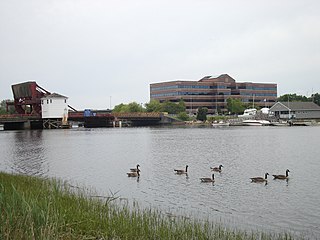
The Neponset River is a river in eastern Massachusetts in the United States. Its headwaters are at the Neponset Reservoir in Foxborough, near Gillette Stadium. From there, the Neponset meanders generally northeast for about 29 miles (47 km) to its mouth at Dorchester Bay between Quincy and the Dorchester section of Boston, near the painted gas tank.

Mattapan is a neighborhood in Boston, Massachusetts, United States. Mattapan is the original Native American name for the Dorchester area, possibly meaning "a place to sit." At the 2010 census, it had a population of 36,480, with the majority of its population immigrants.

The National Register of Historic Places is a United States federal official list of places and sites considered worthy of preservation. In the state of Massachusetts, there are over 4,300 listings, representing about 5% of all NRHP listings nationwide and the second-most of any U.S. state, behind only New York. Listings appear in all 14 Massachusetts counties.

Henry Lillie Pierce was a United States representative from Massachusetts. He was born in Stoughton. He attended the State normal school at Bridgewater, and was engaged in manufacturing. He served as mayor of Boston and as a Republican in the Forty-third and Forty-fourth Congresses of the United States. He declined to be a candidate for renomination, was elected again as mayor of Boston in 1877, and died in that city on December 17, 1896. His interment was in Dorchester South Burying Ground.

Baker's Chocolate is a brand name for the line of baking chocolates owned by Kraft Heinz. Products include a variety of bulk chocolates, including white and unsweetened, and sweetened coconut flakes. It is one of the largest national brands of chocolate in the United States. The company was originally named Walter Baker & Company.

The Neponset Valley Parkway is a historic parkway in southern Boston and Milton, Massachusetts, United States. It is a connecting parkway in the Greater Boston area's network, providing a connection between the Blue Hills Reservation, Neponset River Reservation, and the Stony Brook Reservation. The parkway was constructed between 1898 and 1929 with design assistance from Charles Eliot and the Olmsted Brothers. It was listed on the National Register of Historic Places in 2005.

The Truman Parkway is a historic parkway in Milton and southern Boston, Massachusetts. It runs along the southern boundary of a portion of the Neponset River Reservation and serves as a connection between the Neponset Valley Parkway and the Blue Hills Parkway. The parkway was built in 1931 and added to the National Register of Historic Places in 2005.

The Milton Hill Historic District is a historic district in Milton, Massachusetts. Extending mainly along Adams Street across the top of Milton Hill, it encompasses a residential area of high-style homes dating from the 18th to early 20th centuries. It was listed on the National Register of Historic Places in 1995.

Butler station is a light rail station in Boston, Massachusetts. It serves the MBTA Mattapan Line. It is located at Butler Street in the Lower Mills section of the Dorchester neighborhood. It serves a small residential area sandwiched between the Neponset River, Cedar Grove Cemetery, and Dorchester Park. Butler station has no MBTA bus connections. It is accessible via a wooden mini-high ramp on the station's single island platform.
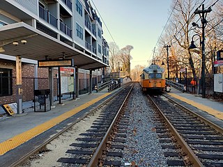
Central Avenue station is a light rail station located off Central Avenue near Eliot Street in Milton, Massachusetts. It serves the Mattapan Line, a branch of the MBTA Red Line. Central Avenue consists of two side platforms which serve the Ashmont–Mattapan High Speed Line's two tracks.

The Ipswich Mills Historic District encompasses a major textile mill complex and associated worker housing along the Ipswich River near the center of Ipswich, Massachusetts. The district includes the factories of the Ipswich Mill Company, and several blocks of modest worker cottages mostly on side streets off Estes and Kimball Streets. The site had been used as for mills since the 17th century, and was purchased by the Ipswich Mill Company in 1868. Mill worker housing was built surrounding the complex through the early 20th century, when River Court, Peatfield Street, and 1st through 6th Streets were laid out. The district was listed on the National Register of Historic Places in 1996.

The Milton Centre Historic District encompasses the traditional civic heart of Milton, Massachusetts. The district is located on Canton Avenue between Readsdale Road and Thacher and Highland Streets, and includes municipal buildings, churches, and residences, most built in the 18th or 19th century. The district was listed on the National Register of Historic Places in 1988.

The Railway Village Historic District is a historic district encompassing a densely populated, predominantly residential, area of eastern Milton, Massachusetts. The 30-acre (12 ha) district lies roughly between East Milton Square and the town line with neighboring Quincy. The area's significant growth occurred after the 1826 construction of the Granite Railway, which transported stone from the nearby granite quarries to the Neponset River. This resulted in the movement to the area of stone workers and related interests. The principal thoroughfare of the district is Adams Street; the district extends along Pierce Street, Granite Place, and Washington Street, and includes properties on intervening and connecting streets.
Neponset River Reservation is a Massachusetts state reservation along the Neponset River in the towns of Milton and Dorchester, near where the river flows through an estuary into the Boston Harbor. It is adjacent to the Dorchester-Milton Lower Mills Industrial District along the River. This was some of the last land retained by Cutshamekin (Massachusett) before he deeded much of the land comprising Dorchester and Milton to English colonists in the 17th century.
Israel Stoughton was an early English colonist in Massachusetts and a colonial commander in the Pequot War. Returning to England, he served as Parliamentarian officer in the First English Civil War.

Bradlee, Winslow & Wetherell (1872–1888) was an architecture firm in Boston, Massachusetts. Its principals were Nathaniel Jeremiah Bradlee (1829–1888), Walter Thacher Winslow (1843–1909) and George Homans Wetherell (1854–1930). Most of the firm's work was local to Boston and New England, with a few commissions as far afield as Seattle and Kansas City.
John Whipple was an early settler of Dorchester in the Massachusetts Bay Colony, who later settled in Providence in the Colony of Rhode Island and Providence Plantations, where the family became well established.

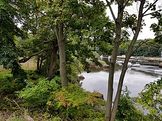
The Lower Neponset River Trail is a 2.4-mile-long (3.9 km) rail trail running along the Neponset River in the Dorchester section of Boston, Massachusetts. It roughly follows the path of the eastern part of the Dorchester and Milton Branch Railroad from the Port Norfolk neighborhood in Dorchester to the Central Avenue T Station in Milton, passing through Pope John Paul II Park, the Neponset Marshes, and the Lower Mills area.


