
Chelsea is a city in Suffolk County, Massachusetts, United States, directly across the Mystic River from Boston. The 2020 census reported Chelsea as having a population of 40,787, thereby making it one of the most densely populated cities in Massachusetts only second to Somerville. With a total area of 2.46 square miles (6.4 km2), Chelsea is the smallest city in Massachusetts in terms of total area. It is the city with the one of the highest percentage of Latino residents in Massachusetts, only second to Lawrence.

Revere is a city in Suffolk County, Massachusetts, located approximately 5 miles (8.0 km) from downtown Boston. Founded as North Chelsea in 1846, it was renamed in 1871 after Revolutionary War patriot Paul Revere. In 1914, the Town of Revere voted to become a city and was incorporated as a city with the inauguration of its first mayor on January 4, 1915. At the 2020 census, the city had a population of 62,186 inhabitants.

Chelsea is a neighborhood on the West Side of the borough of Manhattan in New York City. The area's boundaries are roughly 14th Street to the south, the Hudson River and West Street to the west, and Sixth Avenue to the east, with its northern boundary variously described as near the upper 20s or 34th Street, the next major crosstown street to the north. To the northwest of Chelsea is the neighborhood of Hell's Kitchen, as well as Hudson Yards; to the northeast are the Garment District and the remainder of Midtown South; to the east are NoMad and the Flatiron District; to the southwest is the Meatpacking District; and to the south and southeast are the West Village and the remainder of Greenwich Village. Chelsea was named for an estate in the area, which in turn was named for the Royal Hospital Chelsea in London.

The Metropolitan State Hospital was an American public hospital for the mentally ill, on grounds that extended across parts of Waltham, Lexington, and Belmont, Massachusetts. Founded in 1927, it was at one time the largest and most modern facility of its type in Massachusetts. It was closed in January 1992 as a result of the state's cost-cutting policy of closing its mental hospitals and moving patients into private and community-based settings. The main complex of buildings has subsequently been redeveloped into apartments. The hospital campus was listed on the National Register of Historic Places 1994. The property also housed the Gaebler Children's Center for mentally ill youth.

Massachusetts Avenue is a major diagonal transverse road in Washington, D.C., and the Massachusetts Avenue Historic District is a historic district that includes part of it.
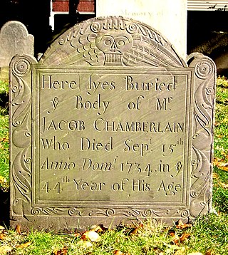
The Rumney Marsh Burying Ground is a historic cemetery on Butler Street between Elm and Bixby Streets in Revere, Massachusetts. It was added to the National Register of Historic Places in 2004. It was the first burying ground of an area that now encompasses Revere as well as neighboring Chelsea and Winthrop.

Bellingham Square Historic District is a historic district encompassing the civic and commercial heart of Chelsea, Massachusetts. Roughly bounded by Broadway, Shawmut, Chestnut, and Shurtleff Streets, the district was almost entirely built in the aftermath of the Great Chelsea Fire of 1908, and is a monument to the civic planning that took place at the time. The district was added to the National Register of Historic Places in 1985.

The Black Rock Gardens Historic District is a historic district in the Black Rock neighborhood of Bridgeport, Connecticut. It encompasses a small residential development built between 1916 and 1920 to provide housing for workers in war-related industries in the city. It is a well-preserved example of one of several such developments made in the city with funding by the United States Housing Corporation, a government agency. The district was listed on the National Register of Historic Places in 1990.

The Acushnet Heights Historic District is a predominantly residential historic district in central New Bedford, Massachusetts. It encompasses a densely-built urban area about 20 acres (8.1 ha) in size, which was developed as a working-class area, beginning in the 1860s, for the many workers in the city's factories. The district was listed on the National Register of Historic Places in 1989. It abuts the North Bedford Historic District, which is just to the south, and includes the following separately-listed properties: the Union Street Railway Carbarn, the Bradford Smith Building, and the Dawson Building.

Wakefield Park Historic District is a residential historic district encompassing a portion of a late-19th/early-20th century planned development in western Wakefield, Massachusetts. The district encompasses sixteen properties on 8 acres (3.2 ha) of land out of the approximately 100 acres (40 ha) that comprised the original development. Most of the properties in the district are on Park Avenue, with a few located on immediately adjacent streets.

Norwichtown is a historic neighborhood in the city of Norwich, Connecticut, United States. It is generally the area immediately north of the Yantic River between I-395 and Route 169.
The Chelsea Parade Historic District encompasses a predominantly residential area north of downtown Norwich. Centered around the Chelsea Parade, a triangular public park, the area has long been a preferred residential area for the city's upper classes, and includes a catalog of architecture from the 18th to 20th centuries. It includes 565 contributing buildings, two other contributing sites, and six contributing objects over an area of 205 acres (83 ha). The district was listed on the National Register of Historic Places in 1989.
The Bayard Park Neighborhood is a neighborhood in Evansville, Indiana which is bounded by Lincoln Avenue, US Highway 41, Washington Avenue and Garvin Street. The Bayard Park Historic District contains approximately 87 acres including 335 contributing buildings and 1 contributing site within the neighborhood boundaries. It was added to the National Register of Historic Places in 1985. The architecture of residential homes in the neighborhood include quaint 1890s Queen Anne cottages, ground-hugging bungalows, American Fourquares, and high-style Early American and English revival types. The neighborhood also features Evansville's first neighborhood park and the East Branch Library, a Carnegie Library funded by the renowned philanthropist Andrew Carnegie.

The Chestnut Hill Historic District encompasses the historic portion of the village of Chestnut Hill that lies in Brookline, Massachusetts, with only slight overlap into adjacent Newton. The 70-acre (28 ha) district is bounded on the north by Middlesex Road, on the east by Reservoir Lane, on the south by Crafts Road and Massachusetts Route 9, and on the west by Dunster Road. A small portion of the district extends south of Route 9, including a few houses and the Baldwin School on Heath Street. The district was listed on the National Register of Historic Places on October 17, 1985.

Kilham & Hopkins was an architectural firm in Boston, Massachusetts formed in 1899 or 1900 by its founding members, Walter Harrington Kilham and James Cleveland Hopkins. The firm later became Kilham, Hopkins & Greeley after William Roger Greeley joined the firm in 1916, and Kilham Hopkins Greeley and Brodie after Walter S. (Steve) Brodie joined the firm in 1945.

Mount Vernon Triangle is a neighborhood and community improvement district in the northwest quadrant of Washington, D.C. The neighborhood is located adjacent to Mount Vernon Square. Originally a working-class neighborhood established in the 19th century, present-day Mount Vernon Triangle experienced a decline in the mid-20th century as it transitioned from residential to commercial and industrial use.

The South Royalton Historic District encompasses the central portion of the village of South Royalton, Vermont. Now the town of Royalton's principal commercial center, it developed in the second half of the 19th century around the depot of the Vermont Central Railroad. The district includes fine examples of Greek Revival and Victorian architecture, and is home to the Vermont Law School. It was listed on the National Register of Historic Places in 1976.

The Samuel Edelman Apartments are a historic multifamily residential building at 97-103 Street in the Dorchester neighborhood of Boston, Massachusetts. It was built about 1908, during a period of major residential development of the area, and is a good example of Colonial Revival architecture in brick and stone. The building was listed on the National Register of Historic Places in 2013.

The Thane Street Historic District is a historic district encompassing a group of apartment houses in the Dorchester neighborhood of Boston, Massachusetts. Extending along Thane Street from Harvard Street, the area was developed in 1910, during a major Jewish migration, and includes a fine sample of Colonial Revival architecture. The district was listed on the National Register of Historic Places in 2020.

The Lawrence Avenue Historic District is a historic district encompassing a small residential area in the Dorchester neighborhood of Boston, Massachusetts. Centered on Lawrence Avenue, the area was developed in the late 19th and early 20th century during a major Jewish migration, and includes a fine sample of Colonial Revival and Queen Anne architecture. The district was listed on the National Register of Historic Places in 2021.


