Camborne is a town in Cornwall, England. The population at the 2011 Census was 20,845. The northern edge of the parish includes a section of the South West Coast Path, Hell's Mouth and Deadman's Cove.

Porthleven is a town, civil parish and fishing port near Helston, Cornwall, England, United Kingdom. The most southerly port in Great Britain, it was a harbour of refuge when this part of the Cornish coastline was infamous for wrecks in the days of sail. The South West Coast Path from Somerset to Dorset passes through the town. The population at the 2011 census was 3,059.

Callington is a civil parish and town in east Cornwall, England, United Kingdom about 7 miles (11 km) north of Saltash and 9 miles (14 km) south of Launceston.

Penryn is a civil parish and town in west Cornwall, England, United Kingdom. It is on the Penryn River about 1 mile (1.6 km) northwest of Falmouth. The population was 7,166 in the 2001 census and had been reduced to 6,812 in the 2011 census, a drop of more than 300 people across the ten-year time gap. There are two electoral wards covering Penryn: 'Penryn East and Mylor' and 'Penryn West'. The total population of both wards in the 2011 census was 9,790.
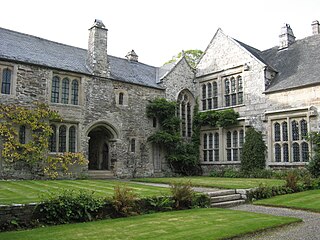
Cotehele is a medieval house with Tudor additions, situated in the parish of Calstock in the east of Cornwall, England, and now belonging to the National Trust. It is a rambling granite and slate-stone manor house on the banks of the River Tamar that has been little changed over five centuries. It was built by the Edgecumbe family in 1458 after the original Manor House was pulled down. Sir Richard Edgecumbe came into the property after fighting for Henry Tudor in the Battle of Bosworth. He was gifted with money and the original Manor House and estate and then proceeded to build Cotehele.

Constantine is a village and civil parish in Cornwall, England, United Kingdom. It is situated approximately five miles (8 km) west-southwest of Falmouth. The electoral ward also bears the same name but includes Budock Water and the surrounding area. At the 2011 census, the population of the ward was 4,709 and the population of the civil parish was 1,789. The parish of Constantine is bounded by the parishes of Mabe, Mawnan, Gweek, Wendron and the north bank of the Helford River.

St Agnes is a civil parish and town on the north coast of Cornwall, England, United Kingdom. The village is about five miles (8 km) north of Redruth and ten miles (16 km) southwest of Newquay. An electoral ward exists stretching as far south as Blackwater. The population at the 2011 census was 7,565.

Kea is a civil parish and village in Cornwall, England, United Kingdom. It is a "large straggling parish" in a former mining area south of Truro.

Grade–Ruan is a civil parish on the Lizard peninsula in Cornwall, England, United Kingdom, approximately ten miles (16 km) south of Falmouth.

St Anthony-in-Meneage is a coastal civil parish and village in Cornwall, England, United Kingdom. The parish is in the Meneage district of the Lizard peninsula. In the 2001 census the parish had a population of 171, decreasing to 168 at the 2011 census.

Porth Navas is a small village in Cornwall, England, UK. The village was called "Cove" until the 19th century development as a granite port and is at the head of a short creek running off the main limb which runs north from the Helford River. It is between Mawnan Smith and Constantine within the civil parish of Constantine.
Linkinhorne is a civil parish and village in southeast Cornwall, England, United Kingdom. The village itself is situated at grid reference SX 320 736 and is approximately four miles (6.5 km) northwest of Callington and seven miles (11 km) south of Launceston. The parish population at the 2011 census including Downgate was 1,541

St Cleer is a civil parish and village in east Cornwall, England, United Kingdom. The village is situated on the southeast flank of Bodmin Moor approximately two miles (3 km) north of Liskeard. The population of the parish in 2001 numbered 3257. This includes Common Moor and had increased to 3,297 at the 2011 census. An electoral ward also exists. The population at the 2011 census is 4,366.

St Ia's Church, St Ives, is a parish church in the Church of England in St Ives, Cornwall, UK. It is dedicated to Ia of Cornwall, a 5th- or 6th-century Irish saint, and is a Grade I listed building.

St Pinnock is a hamlet and civil parish in southeast Cornwall, England, United Kingdom, 3 miles (5 km) south-west of Liskeard. Other settlements in the parish include East Taphouse, and Penfrane, containing 421 inhabitants. The parish church, dedicated to St Pynnochus (Winnoc), is located at OS Grid Ref SX200630.

Merther is a small hamlet and former civil parish, now in the parish of St Michael Penkevil, in the Cornwall district, in the ceremonial county of Cornwall, England. It lies 2 miles (3 km) east of Truro, on the eastern side of the Tresillian River. In 1931 the parish had a population of 150. It was formerly the churchtown of the small parish of Merther, and also the site of a manor house and medieval chapel dedicated to St Cohan. The former parish church is now in ruins.

St Julitta's Church, St Juliot is a Grade II* listed parish church in the Church of England Diocese of Truro in St Juliot, Cornwall.

St Mawes’ Church is a Grade II listed parish church in the Church of England Diocese of Truro in St Mawes, Cornwall, England, UK.

The Percuil River is an estuary and stream draining the southern part of the Roseland Peninsula of Cornwall, UK and is one of three major tidal creeks of the River Fal. The small port and holiday destination of St Mawes is on the western shore and is linked to Place Creek on the eastern shore by the Place Ferry. The ferry is used by walkers on the South West Coast Path.
Presented below is an alphabetical index of articles related to Cornwall: