Earlswood

Last updated

Earlswood
Royal Earlswood Park TQ2848 474.JPG
Victoria Court, Royal Earlswood Park
Surrey UK location map.svg
Red pog.svg
Earlswood
Location within Surrey
Population5,049  [1]
OS grid reference TQ280495
District
Shire county
Region
Country England
Sovereign state United Kingdom
Post town Redhill
Postcode district RH1
Dialling code 01737
Police Surrey
Fire Surrey
Ambulance South East Coast
UK Parliament
List of places
UK
England
Surrey
51°13′41″N0°10′16″W / 51.228°N 0.171°W / 51.228; -0.171

Earlswood is a suburb of Redhill in Surrey, England, which lies on the A23 between Redhill (in the direction of London) and Horley (next to Gatwick Airport). Earlswood Common is a local nature reserve that separates the suburb from the southern outskirts of Reigate and has two lakes and picnic areas. Earlswood station is on the Brighton Main Line. To the east of the line are Royal Earlswood Park, the East Surrey Hospital and Whitebushes.

Contents

History

When the straight turnpike, part of the London to Brighton railway, was cut between Earlswood Common and the railway line, there was a claim that traces of a Roman villa [2] were discovered, but no evidence has so far been found to indicate any Roman presence. The area south of the common, locally known as Whitebushes, was formerly a wilderness containing many clay pits that may be linked to the reputed Roman remains. Most trees of the Weald that covered Earlswood Common were cut down in the 17th century by order of local noble, Lord Monson and the land was inclosed in 1886. [2] Brickworks were a considerable employer in the Victorian period and in 1911. [2]

In 1863 Earlswood joined Meadvale, Redhill and Reigate to become part of the newly formed municipal borough of Reigate when it was granted this status by royal charter. [3]

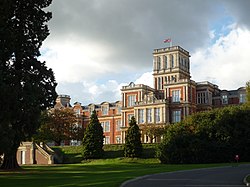
Earlswood was home to the Royal Earlswood psychiatric hospital, founded as a 'national home' and opened by Albert, Prince Consort, [2] which functioned until 1997. Also here was the Royal Philanthropic Society's reform school, from 1849 [2] until 1988. The site has been redeveloped into a housing area called Royal Earlswood Park, providing apartments and houses.

The suburb is served by Earlswood railway station, with trains running from Bedford to Three Bridges via London Bridge. The station previously had a third platform which gave access to the Royal Earlswood Hospital.

Earlswood Common was converted the late 1800s from open pasture to a pleasure ground, which remained in use until World War II. The lower lake has a concrete bottom and was used during the First World War to test the ability of primitive tanks to cross flooded landscapes, having previously been used for summer swimming.

Demography

At the 2001 census area, the ward named Earlswood and Whitebushes had a population of 8,234; Earlswood is identifiable as Reigate and Banstead 14A, 14D and 14E (Lower Layer Super Output Areas) with a population of 5,049. [1]

Geography

Earlswood Common is a Local Nature Reserve. [4] [5] It contains two artificial landscaped lakes, which are used for recreational purposes. The upper lake has ducks and wildfowl. Until 2019, much of Earlswood Common had formed Earlswood Common golf course. The golf course was forced to close in March 2019, after 130 years, due to the closure of the Redhill & Reigate Golf Club which had previously maintained the Earlswood course. [6]

Localities

Earlswood

An area of predominantly Victorian housing, much of it terraced and semi-detached, immediately south of Redhill town centre bordered to the north by Hooley lane, to the west by the A23 Brighton Road, to the south by the Royal Earlswood Park housing development and to the east by fields. Redhill Brook runs north-south through the middle of Earlswood but is not visible in most of it. Two train lines run through Earlswood. The Redhill and Quarry Lines, both part of the Brighton Line, merge just north of Earlswood and run through Earlswood Station although there is no Quarry Line Platform. The Redhill to Tonbridge line passes through north Earlswood in between Redhill and Nutfield stations.

There are a nursery, primary and junior school over two sites in north Earlswood combined under the umbrella of the Earlswood Schools Federation. The schools are very popular and, along with the plentiful green space and good transport links, have attracted many young families to the area.

There are a few places of religious worship in Earlswood. There is St John's church on St Johns Road, opposite Earlswood, and there is also a Mosque on Earlswood Road, the Redhill Jamia Mosque Al-Mustafa. This is one of 3 mosques in the Redhill area, along with Masjid Al Yaqeen on Warwick Road, Redhill, and Masjid ul Emaan on Frenches Road near Watercolour and Merstham.

South Earlswood

One sub-area of Earlswood, South Earlswood is a separate neighbourhood containing approximately half of the housing, which constitutes the main land use in Earlswood. [7] [8] Separating it from the north are Earlswood Common and the Greensand Way, which follows the Greensand Ridge from Haslemere to Kent. Immediately adjoining South Earlswood is the village or neighbourhood of Whitebushes, which is contiguous therefore, apart from councillors, is difficult to separate artificially. [9]

Whitebushes

A mixed housing estate built in the 1970s and early 1980s,mainly consisting of 4 and 3 bedroom homes and some flats.surrounded by pre-existing farmland, South Earlswood and the railway line. East Surrey Hospital opened in 1979 to its north. A small portion of farmland remains common land where (traditionally) gypsy horses, used for riding lessons and transport, have grazed since the 1950s.

The area has been occupied since medieval times and probably before that, as evidenced by archaeological finds nearby of an axe [10] and flint flakes. [11] The surrounding farms date back to the 13th and 14th centuries, notably Hazelhurst Farm from 1203 and Dean Farm from 1316. [12] There is evidence of a medieval farmstead in Woodlands Field, off Green Lane. This consists mainly of soil marks in a square of about 350m and an adjoining L-shaped mark. The pottery has been dated to 1250–1350. [13]

In the 19th century a number of brick works sprung up in the area. The Reigate Isolation Hospital was established in 1884 and later renamed to the Reigate Rural District Infectious Diseases Hospital. [14] In 1900 a second establishment, the Reigate Borough Isolation Hospital, was opened. Around 1927 the two establishments were combined into a single Isolation Hospital run by the Reigate Joint Hospital Board as part of the Redhill County Hospital. [15] In 1960 the site was acquired by University College Hospital and renamed Jordan's Hospital [16] for the treatment of Tropical Diseases, especially leprosy. The site was sold for development, demolished and in 1970 and the estate between Green Lane and the railway, including Jordans Close, was built.

The Brighton Main Line passes the west of Whitebushes and was opened in 1841. An ancient trackway [17] along what is now Green Lane, The Brow and the western leg of Bushfield Drive, links Whitebushes to Earlswood station to the north and Salfords station to the south. Somewhat circuitous routes under the railway link to the parking areas by these stations for those unwilling to walk.

Local governance

Surrey County Council Following boundary changes in response to the new communities built at The Watercolour and Park 25 developments East of Redhill, Earlswood is now split between two divisions at Surrey County Council level. Earlswood North falls with the Redhill East division and Earlswood South falls within the Earlswood and Reigate South division. This does cause some confusion as there is also a Redhill East ward at borough council level which Earlswood is not part of. Both are elected every four years. They are currently represented by:

Redhill East: Mr Jonathan Essex of the Green Party who, in being elected, became the first member of his party to sit on Surrey County Council.

Earlswood and Reigate South: Catherine Margaret Baart (Green Party (England and Wales)), was voted in by the electorate in 2021. [18]

Reigate and Banstead At Borough council Earlswood North and South are combined to form one division, simply Earlswood. Three Earlswood councillors sit on Reigate and Banstead borough council, who are:

ElectionMember [19]

Ward

2019Ruth RitterEarlswood and Whitebushes
2021Joseph BootonEarlswood and Whitebushes
2021Della TorraEarlswood and Whitebushes

Amenities

Earlswood Common, an 89-hectare (220-acre) local nature reserve, is managed by Reigate and Banstead Borough Council.

Football club Redhill F.C. has its ground, Kiln Brow, on a site in Earlswood on the east side of the A23, immediately north of East Surrey Hospital.

See also

Related Research Articles

<span class="mw-page-title-main">Coulsdon</span> Town in south London, England

Coulsdon, is a town in south London, England, within the London Borough of Croydon. Coulsdon was an ancient parish in the county of Surrey that included the settlements of Purley and Kenley. It was merged with Sanderstead in 1915 to form the Coulsdon and Purley Urban District and has formed part of Greater London since 1965.

<span class="mw-page-title-main">Reigate and Banstead</span> Borough and non-metropolitan district in England

Reigate and Banstead is a local government district with borough status in Surrey, England. Its council is based in Reigate and the borough also includes the towns of Banstead, Horley and Redhill. Parts of the borough are within the Surrey Hills, a designated Area of Outstanding Natural Beauty. Northern parts of the borough, including Banstead, lie inside the M25 motorway which encircles London.

<span class="mw-page-title-main">Reigate</span> Town in Surrey, England

Reigate is a town in Surrey, England, around 19 miles (30 km) south of central London. The settlement is recorded in Domesday Book in 1086 as Cherchefelle and first appears with its modern name in the 1190s. The earliest archaeological evidence for human activity is from the Paleolithic and Neolithic, and during the Roman period, tile-making took place to the north east of the modern centre.

<span class="mw-page-title-main">Redhill, Surrey</span> Town in Surrey, England

Redhill is a town in the borough of Reigate and Banstead within the county of Surrey, England. The town, which adjoins the town of Reigate to the west, is due south of Croydon in Greater London, and is part of the London commuter belt. The town is also the post town, entertainment and commercial area of three adjoining communities : Merstham, Earlswood and Whitebushes, as well as of two small rural villages to the east in the Tandridge District, Bletchingley and Nutfield.

<span class="mw-page-title-main">Horley</span> Town in Surrey, England

Horley is a town in the borough of Reigate and Banstead in Surrey, England, south of the towns of Reigate and Redhill. The county border with West Sussex is to the south with Crawley and Gatwick Airport close to the town.

<span class="mw-page-title-main">Reigate (UK Parliament constituency)</span> United Kingdom parliamentary constituency

Reigate is a constituency in Surrey represented in the House of Commons of the UK Parliament since 1997 by Crispin Blunt, originally of the Conservative Party, but as of October 2023, sitting as an Independent, after having the whip suspended.

<span class="mw-page-title-main">Hooley</span> Human settlement in England

Hooley is a village in the borough of Reigate and Banstead in Surrey, England. Within its small grid of streets is the 13th-century church of Chipstead which has been, since time immemorial, its ecclesiastical parish. Hooley is connected via paths and the A23 road to the larger community of Coulsdon, to the north, in the London Borough of Croydon.

<span class="mw-page-title-main">Salfords</span> Human settlement in England

SalfordsSAL-fudz) is a village in the borough of Reigate and Banstead in Surrey, England. It lies approximately 3 miles (4.8 km) south of Redhill on the A23 London to Brighton road. The village is within the civil parish of Salfords and Sidlow which covers a population of 3,069, and has a parish council.

<span class="mw-page-title-main">Banstead</span> Town in Surrey, England

Banstead is a town in the borough of Reigate and Banstead in Surrey, England. It is 3 miles (5 km) south of Sutton, 5 miles (8 km) south-west of Croydon, 8 miles (13 km) south-east of Kingston-upon-Thames, and 13 miles (21 km) south of Central London.

<span class="mw-page-title-main">Meadvale</span> Human settlement in England

Meadvale or less commonly Mead Vale is a southern residential suburb that straddles borders of Redhill and Reigate in the borough of Reigate and Banstead in Surrey, and one of two which do so. The average elevation of the district is higher than the centres of each of the towns – Meadvale is bisected east-west by the Greensand Way at the top of a moderately low section of the Greensand Ridge. Its population, as broadly defined on its ward definition, is 3,090 spread over 64 hectares based upon the most recent national census.

<span class="mw-page-title-main">Nork, Surrey</span> Human settlement in England

Nork is a residential area of the borough of Reigate and Banstead in Surrey and borders Greater London, England. Nork is separated from its post town Banstead only by the A217 dual carriageway, and the built-up area is also contiguous with similar parts of Tattenham Corner and Burgh Heath. A thin belt of more open land separates it from the communities to the north: Epsom, Ewell, Cheam and Belmont. There are two parades of shops, one called the Driftbridge and another at the north-eastern end of Nork Way, the street which runs centrally through the residential area. Nork lies on chalk near the top of the gentle north-facing slope of the North Downs, 175 m (575 ft) above sea level at its highest point.

<span class="mw-page-title-main">Kingswood, Surrey</span> Human settlement in England

Kingswood or Kingswood with Burgh Heath is a residential area on the North Downs in the Borough of Reigate and Banstead in Surrey, England. Part of the London commuter belt, Kingswood is just to the east of the A217 separating it from Tadworth and has a railway station. Burgh Heath in its north is combined with it to form a ward. Reigate is 3.6 miles (5.8 km) south of its centre and London is 15.5 miles (24.9 km) to the north northeast. Kingswood with Burgh Heath had a population of 6,891 in 2011.

Lower Kingswood is a village located in Surrey, just within the M25 motorway. It is between Kingswood and Reigate, and is bisected by the A217 dual carriageway. Neighbouring settlements include Tadworth and Reigate also Redhill.

Reigate was a hundred in what is now Surrey, England. It was geographically consonant with the southern two thirds of Borough of Reigate and Banstead together with two parishes in Tandridge and fractions of former parishes in the London Borough of Croydon and Borough of Crawley, West Sussex. Accordingly, it included the medieval-established town of Reigate with its motte castle and land which become the towns of Redhill and Horley.

<span class="mw-page-title-main">Earlswood Common</span>

Earlswood Common is an 89.1-hectare (220-acre) Local Nature Reserve in Redhill in Surrey. It is owned and managed by Reigate and Banstead Borough Council.

<span class="mw-page-title-main">East Surrey Hospital</span> Hospital in Surrey, England

East Surrey Hospital is a National Health Service hospital in the Whitebushes area to the south of Redhill, in Surrey, England. It is managed by the Surrey and Sussex Healthcare NHS Trust.

References

  1. 1 2 "Local statistics - Office for National Statistics". www.ons.gov.uk.
  2. 1 2 3 4 5 Malden, H.E., ed. (1911). "Parishes: Reigate". A History of the County of Surrey: Volume 3. Institute of Historical Research. Retrieved 29 October 2013.
  3. Hooper, Wilfrid (1979) [1945]. Reigate: Its story through the ages. Guildford: Surrey Archaeological Society. pp. 180–181. ISBN   978-0-90-396712-9.
  4. "Earlswood Common". Local Nature Reserves. Natural England. Retrieved 4 August 2013.
  5. "Map of Earlswood Common". Local Nature Reserves. Natural England. Retrieved 4 August 2013.
  6. Seymour, Jenny (29 January 2019). "130-year-old Redhill and Reigate Golf Club to close because it is 'financially unviable'". SurreyLive. Retrieved 26 June 2019.
  7. "Ordnance Survey map, courtesy of English Heritage". Archived from the original on 24 April 2012.
  8. Grid square map Ordnance survey website
  9. Office for National Statistics website. Census area: as to South Earlswood 014A refers exactly.
  10. "Search results". Exploring Surrey's Past.
  11. "Search results". Exploring Surrey's Past.
  12. Medieval Settlement Patterns in NE Horley by R Ellaby, 1982
  13. "Search results". Exploring Surrey's Past.
  14. "19th Century – A History of Whitebushes, Surrey".
  15. "20th Century and Present – A History of Whitebushes, Surrey".
  16. "Lost_Hospitals_of_London". www.ezitis.myzen.co.uk.
  17. Earlswood-Salfords-Horley ancient trackway; Roger Ellaby 2000
  18. "Election results for Earlswood and Reigate South". mycouncil.surreycc.gov.uk. 4 October 2022.
  19. "Reigate and Banstead councillors".

Commons-logo.svg Media related to Earlswood at Wikimedia Commons