
Loosley Row is a hamlet in the civil parish of Lacey Green, Buckinghamshire, England. It is located in the Chiltern Hills to the east of the main town of Princes Risborough. In the 2011 Census, the population was recorded in the Lacey Green Parish, which included Speen, parts of Walter's Ash, and Lacey Green, with a combined population of 2,559.

Coombe Keynes is a hamlet, civil parish and depopulated village in the Purbeck district of Dorset, England. The village is about 2 miles (3 km) south of Wool and about 5 miles (8 km) west-south-west of Wareham.

Boxgrove is a village, ecclesiastical parish and civil parish in the Chichester District of the English county of West Sussex, about 3.5 miles (5.6 km) north east of the city of Chichester. The village is just south of the A285 road which follows the line of the Roman road Stane Street.

Brasted is a village and civil parish in the Sevenoaks District of Kent, England. Brasted lies on the A25 road, between Sundridge and Westerham; the road is named Westerham Road, High Street and Main Road as it passes through the village east to west. Brasted is 6 km west of Sevenoaks town. The parish had a population of 1321 and includes the hamlets of Brasted Chart, Toys Hill and Puddledock. The village of Brasted has a number of 18th-century houses with several antique shops, pubs and residences. The parish church is dedicated to St Martin.

Blythburgh is a village and civil parish in the East Suffolk district of the English county of Suffolk. It is 4 miles (6.4 km) west of Southwold and 5 miles (8.0 km) south-east of Halesworth and lies on the River Blyth. The A12 road runs through the village which is split either side of the road. At the 2011 census the population of the parish was 297. The parish includes the hamlets of Bulcamp and Hinton.

Astwick is a hamlet and civil parish in the Central Bedfordshire district of the county of Bedfordshire, England. It lies 12+1⁄2 miles (20 km) south-east of the county town of Bedford. Its population is included within Stotfold civil parish.

Chalgrave is a civil parish in the Central Bedfordshire district of Bedfordshire, England. The hamlets of Tebworth and Wingfield are in the west of the parish, with the church and manor in the east. Nearby places are Toddington, Chalton, Houghton Regis, and Hockliffe. Before 1929, the parish also included part of the village of Hockliffe.
Barwick is a scattered hamlet and civil parish in the north-west part of the English county of Norfolk. It is situated adjacent to the slightly larger village of Stanhoe, some 15 miles (24 km) north-east of King's Lynn and 50 miles (80 km) north-west of the city of Norwich.
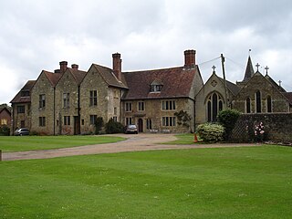
Easebourne is a village, Anglican parish and civil parish in the Chichester District of West Sussex, England. It is half a mile (0.8 km) north of Midhurst, across the River Rother on the A272 and A286 roads. The parish includes the hamlet of Henley to the north. In the 2001 census there were 708 households with a total population of 1,717 of whom 785 were economically active.

South Stoke is a rural village and civil parish in the Arun District of West Sussex, England. It is centred two miles (3 km) north of Arundel also on the west bank of the River Arun and on the edge of Arundel Park. It is reached by road, footpath or river from Arundel. A footpath also leads to North Stoke on the east bank. The civil parish, which includes the hamlet of Offham, covers an area of 534.86 hectares. At the 2011 Census the population of the village was included in the civil parish of Houghton.

Graffham is a village, Anglican parish and civil parish in West Sussex, England, situated on the northern escarpment of the South Downs within the South Downs National Park. The civil parish is made up of the village of Graffham, part of the hamlet of Selham, and South Ambersham. It forms part of the Bury Ward for the purposes of electing a Councillor to Chichester District Council.

Trotton with Chithurst is a civil parish in the Chichester district of West Sussex, England. Trotton is on the A272 road 7 miles (11 km) west of Midhurst. Chithurst is about 1 mile (1.6 km) north west of Trotton. The parish also contains the hamlet of Dumpford.

Rogate is a village and civil parish in the Chichester district of West Sussex, England, in the Western Rother valley. The village is on the A272 road 5.6 miles (9.0 km) west of Midhurst and 5 miles (8.0 km) east of Petersfield, Hampshire. The civil parish includes the villages of Rogate and Rake and the hamlets of Haben, Fyning, Hill Brow, Langley, Durford, Wenham, Durleighmarsh and Terwick Common.
Harting is a civil parish in the Chichester District of West Sussex, England. It is situated on the northern flank of the South Downs, around 3.5 miles (5.6 km) southeast of Petersfield in Hampshire. It comprises the village of South Harting and the hamlets of East Harting, West Harting and Nyewood.
Elsted is a village, Anglican parish and former civil parish, now in the civil parish of Elsted and Treyford, in the Chichester district of West Sussex, England. The village is on the Midhurst to South Harting Road 4.5 miles (7.2 km) west of Midhurst. In 1961 the civil parish had a population of 188. On 1 April 2003 the civil parish was abolished and merged with Treyford to form "Elsted & Treyford".

Cowlam is a hamlet in the civil parish of Cottam, in the East Riding of Yorkshire, England, and in the Yorkshire Wolds. The hamlet is on the B1253 Bridlington to North Grimston road, 17 miles (30 km) north from the county town of Beverley, 2 miles (3 km) east from the village of Sledmere, and 2.5 miles (4 km) north-west from the parish hamlet of Cottam. The hamlet contains eight houses and two farms.

West Dean is a village, Anglican parish and civil parish in the District of Chichester in West Sussex, England 5 miles (8 km) north of Chichester on the A286 road just west of Singleton. The parishes include the hamlets of Binderton and Chilgrove.

South Harting is a village within Harting civil parish in the Chichester district of West Sussex, England. It lies on the B2146 road, 4 miles (6.4 km) southeast of Petersfield in Hampshire.
West Harting is a hamlet in the Chichester district of West Sussex, England. At the 2011 Census the population of the hamlet was included in the civil parish of Harting. It lies just off the B2146 road 2.4 miles (4 km) southeast of Petersfield and encompasses three additional houses which come under their own hamlet name of Quebec. All evidence suggests there was originally one main farm in the hamlet, named Manor Farm, which still exists to this day. However, there are several other farms which own the remainder of the land around West Harting in the hamlet's vicinity.

Leigh is a civil parish in the English county of Staffordshire. The parish includes the village of Church Leigh, together with the settlements of Withington, Upper Leigh, Lower Leigh, Morrilow Heath, Middleton Green, Dodsley, Godstone, Nobut and Field.

