
Boxgrove is a village, ecclesiastical parish and civil parish in the Chichester District of the English county of West Sussex, about 3.5 miles (5.6 km) north east of the city of Chichester. The village is just south of the A285 road which follows the line of the Roman road Stane Street.

Ashby Puerorum is a small village and former civil parish, now in the parish of Greetham with Somersby, in the East Lindsey district of Lincolnshire, England. The village situated 6 miles (10 km) north-west from Partney, 4 miles (6 km) east from Horncastle, to the north of the A158 road, and to the west of Bag Enderby. In 1931 the parish had a population of 97. On 1 April 1936 the parish was abolished and merged with Somersby.

Aldingbourne is a village, Anglican parish and civil parish in the Arun District of West Sussex, England. Its centre is 4 miles (6.4 km) north of Bognor Regis and 4 miles (6.4 km) east of Chichester with the A29 and A27 main roads running through it.

Blyton is a village and civil parish within the West Lindsey district of Lincolnshire, England. It is situated approximately 4 miles (6 km) north-east from Gainsborough. From Blyton the village of Laughton lies to the north, and Pilham to the south-east, while the course of the River Trent runs nearby to the west.

Preston or Preston Village is a suburb of Brighton and Hove, in the ceremonial county of East Sussex, England. It is to the north of the centre. Originally a village in its own right, it was eventually absorbed into Brighton with the development of the farmland owned by the local Stanford family, officially becoming a parish of the town in 1928. Stanford-owned land to the south of Preston Manor was given to the town and now makes up Preston Park, one of the largest parks in the now conjoined city of Brighton and Hove. The park hosts some of the city's major public events such as Brighton Pride.

Selham is a small village and former civil parish, now in the parish of Graffham, in the Chichester district of West Sussex, England. It lies south of the A272 road 3 miles (4.8 km) east of Midhurst. It is mainly in the parish of Graffham, but partly in that of Lodsworth to the north. In 1931 the parish had a population of 65.

Iping is a village and former civil parish, now in the parish of Stedham with Iping, in the Chichester district of West Sussex, England. It lies just off the A272 road 2 miles (3.2 km) west of Midhurst, on the River Rother. In 1931 the parish had a population of 400.

Stedham is a village and former civil parish, now in the parish of Stedham with Iping, in the Chichester district of West Sussex, England, on the A272 road 1.5 miles (2.4 km) west of Midhurst. In 1961 the parish had a population of 649. On 1 April 1974 the parish was abolished and merged with Iping to form "Stedham with Iping".
Elsted is a village, Anglican parish and former civil parish, now in the civil parish of Elsted and Treyford, in the Chichester district of West Sussex, England. The village is on the Midhurst to South Harting Road 4.5 miles (7.2 km) west of Midhurst. In 1961 the civil parish had a population of 188. On 1 April 2003 the civil parish was abolished and merged with Treyford to form "Elsted & Treyford".
Treyford is a hamlet, Anglican parish and former civil parish, now in the civil parish of Elsted and Treyford, in the Chichester district of West Sussex, England. The hamlet sits on the Elsted to Bepton Road 4 miles (6.4 km) southwest of Midhurst. In 1931 the civil parish had a population of 104.

Oving is a small village, and civil and ecclesiastical parish in the Chichester District of West Sussex, England. The village lies about 2.5 miles (4.0 km) east of the city of Chichester. The civil parish includes the settlements of Colworth, Drayton, Merston, and Shopwhyke.

Ruston Parva is a hamlet and former civil parish, now in the parish of Harpham, in the East Riding of Yorkshire, England. It is situated approximately 8 miles (13 km) south-west of Bridlington and lies just north of the A614. In 1931 the parish had a population of 84. On 1 April 1935 the parish was abolished and merged with Harpham.

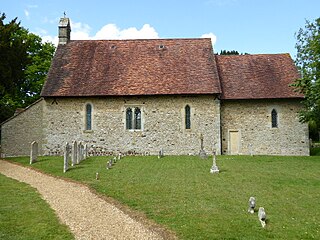
East Marden is a village and former civil parish, now in the parish of Marden, in the Chichester district of West Sussex, England. It is on the spur of the South Downs It is first mentioned in the Domesday Book as Meredone and was given in 1086 to Roger, Earl of Montgomery. The church, St Peters, dates from the 12th century and is still used for worship every other Sunday. Its oldest house today dates back to 1728. The village, some 100 metres above sea level, is in an area of unusually high rainfall. Its most famous landmark is the thatched well on the village green. The population has remained static for over a century. In 1931 the parish had a population of 80. On 1 April 1933 the parish was abolished to form "Marden".
East Lavant is one part, which along with Mid Lavant make up the village of Lavant in the Chichester district of West Sussex, England. It lies just east of the A286 road 2.2 miles (3.5 km) north of Chichester. It is in the civil parish of Lavant. East Lavant has a collection of historic cottages and a public house. The manor appears in Domesday as Loventone. In 1851 the parish had a population of 421. On 29 September 1873 the parish was abolished and merged with West Lavant to form "Lavant".

Westhampnett is a village, Anglican parish and civil parish in the district of Chichester in West Sussex, England, located 1 mile (1.6 km) northeast of Chichester on the former A27 road, now by-passed. The village is pre-Norman and is home to many listed buildings, including the Saxon church of St Peter, where three bishops of Chichester are buried. The parish of Westhampnett includes most of Goodwood estate, its golf course, motor-racing circuit and airfield.

Hunston is a village, Anglican parish and civil parish in the Chichester district of West Sussex, England. It lies on the B2145 Road two miles (3.2 km) south of Chichester. The Anglican parish is in the Diocese of Chichester.

North Mundham is a village, Anglican parish and civil parish in the Chichester district of West Sussex, England. It lies on the B2166 road two miles (3.2 km) southeast of Chichester. The parish includes the village of Runcton. The Anglican parish includes the neighbouring settlements of South Mundham, Runcton and Merston.

Egdean is a small village in the civil parish of Petworth, in the Chichester district of West Sussex, England. It lies just off the A283 road 1.7 miles (2.8 km) southeast of Petworth. In 1931 the parish had a population of 82. On 1 April 1933 the parish was abolished and merged with Petworth.

Cuxwold is a village and former civil parish, now in the parish of Swallow, in the West Lindsey district of Lincolnshire, England. It lies in the Lincolnshire Wolds, 4 miles (6 km) east from Caistor and 10 miles (16 km) south-west from Grimsby. In 1931 the parish had a population of 98. On 1 April 1936 the parish was abolished and merged with Swallow.

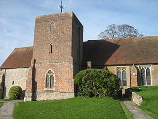
Racton is a hamlet in the civil parish of Stoughton, in the Chichester district of West Sussex, England. It lies on the B2147 road 2.1 miles (3.4 km) northeast of Emsworth. The hamlet lies along the River Ems. 0.4 miles north of the hamlet is the Racton Monument, constructed between 1766 and 1775 by the 2nd Earl of Halifax. Another prominent structure just outside the hamlet is Lordington Manor, former home of the Pole family. St Peter's Church, located in the centre of the hamlet, is a Grade I listed building, dating from the 12th-13th century. In 1931 the parish had a population of 113. On 1 April 1933 the parish was abolished and merged with Stoughton.

