Related Research Articles
Ejersa Goro is a town in eastern Ethiopia. Located outside the city of Harar in the East Hararghe Zone of the Oromia Region, it has a latitude and longitude of 9°29′N42°14′E and an elevation of 2780 meters above sea level. It is the administrative center of Jarso Aanaa.
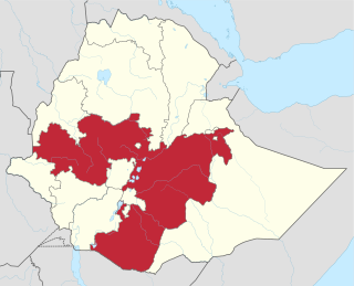
Oromia is a regional state in Ethiopia and the homeland of the Oromo people. Under Article 49 of Ethiopian Constitution, the capital of Oromia is Addis Ababa, also called Finfinne. The provision of the article maintains special interest of Oromia by utilizing social services and natural resources of Addis Ababa.

Bale Zone is a zone in Oromia Region of Ethiopia. Bale is bordered on the south by the Ganale Dorya River which separates it from Guji Zone, on the west by the West Arsi Zone, on the north by Arsi Zone, on the northeast by the Shebelle River which separates it from West Hararghe Zone and East Hararghe Zone, and on the east by the Somali Region.
West Hararge is a zone in the Oromia Region of Ethiopia. West Hararghe takes its name from the former province of Hararghe. West Harerge is bordered on the south by the Shebelle River which separates it from Bale, on the southwest by Arsi, on the northwest by the Afar Region, on the north by the Somali Region and on the east by East Hararghe. Towns in West Hararghe include Chiro, Badessa, Gelemso, and Mieso, Asebot.
East Hararghe is a zone in the Oromia Region of Ethiopia. East Hararghe Zone is bordered on the southwest by Bale, on the west by West Hararghe Zone, on the north by Dire Dawa and on the north and east by the Somali Region. The Harari Region is an enclave inside this zone
Most inhabited by Somalis
Doba is a woreda in Oromia Region, Ethiopia. It is named after its major town Doba. Part of the West Haraghe, Doba is bordered on the south by Chiro, on the west by Mieso, on the north by the Somali Region, on the east by the East Hararghe, and on the southeast by Tulo.
Mesela is a woreda in Oromia Region, Ethiopia. Part of the West Hararghe Zone, Mesela is bordered on the southwest by the Galetti River which separates it from Chiro, on the northwest by Tulo, and on the east by the East Hararghe Zone. Towns in Mesela include Goro Reye and Mesela.
Nannawa Chiro is one of the Aanaas in Oromia Regional State, Ethiopia. Part of the West Hararghe Zone, Chiro is bordered on the south by Kuni, on the west by Guba Koricha, on the northwest by Mieso, on the north by Doba, on the northeast by Tulo, and on the east by the Galetti River which separates it from Mesela and the East Hararghe Zone. It is part of the former Chiro district that was divided to create Nannawa Chiro and Gemechis districts and Chiro Town.
Guba Koricha is a Aanaa in Oromia Regional State, Ethiopia. Located in the West Hararghe Zone, Guba Koricha, according to the OCHA map (2005) is bordered on the south by Darolebu, on the southwest by the Arsi Zone, on the west by the Afar Region, on the north by Mieso, on the northeast by Chiro, on the east by Habro, and on the southeast by Boke. Woreda of Anchar was separated from Guba Koricha.
Habro is one of the Aanaas in the Oromia of Ethiopia. It is named after the former Aanaa of the same name. Part of the West Hararghe Zone, the district is bordered on the south by Darolebu, on the west and north by Guba Koricha, on the northeast by Kuni, and on the southeast by Boke. Towns in Habro include Belbelti, Gelemso and Wachu.
Kuni is one of the Aanaas in the Oromia Regional State of Ethiopia. Part of the West Hararghe Zone, Kuni is bordered on the south by Boke, on the west by Habro, on the northeast by Chiro, and on the east by the Galetti River, which separates it from the East Hararghe Zone.
Bedeno is a District of Ethiopia in Oromia, Ethiopia. It is named after the administrative center of the district, Bedeno. Part of the East Hararghe Zone, Bedeno is bordered on the south by Gola Odana Meyumuluke, on the southwest by Malka Balo, on the west by Deder, on the northwest by Meta, on the north by Jarso, on the northeast by Kurfa Chele, and on the east by Girawa. Towns include Furda.
Kombolcha is a woreda in Oromia Region, Ethiopia. Part of the East Hararghe Zone, Kombolcha is bordered on the south by the Harari Region, on the southwest by Haro Maya, on the northwest by Dire Dawa, on the north by the Somali Region, and on the east by Jarso. The administrative center of the woreda is Melka Rafu.
Gursum is one of the Districts in the Oromia region of Ethiopia. Part of the East Hararghe Zone, Gursum is bordered on the south by Babille, on the west by the Harari Region, on the north by Jarso, and on the east by the Gursum district in the Somali region. The administrative center of the woreda is Funyan Bira.
Babile is one of the districts in the East Hararghe Zone of Oromia Region in Ethiopia. It is named after one of the 12 major clans of the Oromo people, the Babille Oromo. Part of the East Hararghe Zone, Baabile is bordered on the south and east by the Somali Region, on the west by Fedis, and on the north by Gursum; the Fafen River defines a portion of Babille's eastern border. The administrative center of this woreda is Babille Town. Other key towns of this district include Bisidimo and many kebeles.
Haramaya is one of the woreda in the East Hararghe zone, Oromia Region, Ethiopia. It is named from the Haramaya lake that found in the woreda. The word Haramaya is come from two Oromo language word's[Hara and Maya] Hara means Lake and maya means name of person so Haramaya means the 'lake of maya'. Haramaya is bordered on the south by Kurfa Chele, on the west by Kersa, on the north by Dire Dawa, on the east by Kombolcha, and on the southeast by the Harari Region. The woreda has 33 rural keble and 4 administrative towns. Towns include Haramaya, Addele, Aweday and sharif kaled.
Goro Gutu is a Aanaa in Oromia, Ethiopia. This district is named after Mount Goro Gutu, its tallest mountain. Part of the East Hararghe Zone, Goro Gutu is bordered on the south by Deder, on the west by the West Hararghe Zone, on the north by the Somali Region, and on the east by Meta. The administrative center is ; Karamile other towns include Boroda towns
Deder is a Aanaa in Oromia, Ethiopia. It is named after the administrative center, Deder. Part of the East Hararghe Zone, Deder is bordered on the south by Malka Balo, on the west by the West Hararghe Zone, on the north by Goro Gutu, on the east by Meta, and on the southeast by Bedeno. Towns in the district include Kobo, Deder, Soqaa.
Malka Balo is a Districts of Ethiopia in Oromia, Ethiopia. Part of the East Hararghe Zone, Malka Balo is bordered on the west by the West Hararghe Zone, on the north by Deder, on the northeast by Bedeno, and on the southeast by Gola Odana Meyumuluke; part of the boundary with the West Hararghe Zone is defined by the Galetti River. The administrative center for this woreda is Jaja; other towns include Bareda,Harawacha and Harew.
Gola Oda is a District in Oromia, Ethiopia. It was part of former Gola Odana Meyumuluke district what was divided for Gola Oda and Meyumuluke districts. Part of the East Hararghe Zone, Gola Odana Meyumuluke is bordered on the south by the Shebelle River which separates it from the Bale Zone, on the southwest by the Galetti River which separates it from the West Hararghe Zone, on the northwest by Malka Balo, on the north by Bedeno, on the northeast by Girawa, on the east by Fedis, and on the southeast by the Erer River which separates it from the Somali Region. The administrative center of this woreda is Burka.
References
- 1 2 3 Eastern Oromo at Ethnologue (27th ed., 2024)

- ↑ 1994 Population and Housing Census of Ethiopia: Results for Oromia Region, Vol. 1, part 1 Archived November 15, 2009, at the Wayback Machine , Tables 2.15 (accessed 6 April 2009)