
Eastham is a town in Barnstable County, Massachusetts, United States, Barnstable County being coextensive with Cape Cod. The population was 5,752 at the 2020 census.

Brewster is a town in Barnstable County, Massachusetts, United States, Barnstable County being coextensive with Cape Cod. The population of Brewster was 10,318 at the 2020 census.

The Eastham Windmill, located in Eastham, Massachusetts, is the oldest windmill on Cape Cod. It was constructed by Eastham resident Thomas Paine in Plymouth in 1680. It was first moved to nearby Truro in 1770, then finally to Eastham in 1793. In 1808 the windmill was moved to its present location, near the Eastham Town Hall and the Eastham Public Library. Eastham Windmill, as part of the Eastham Center Historic District, was added to the National Register of Historic Places in 1999.

Westminster Village–Academy Hill Historic District encompasses the historic first town center of Westminster, Massachusetts, as well as its later early-19th century commercial core. Centered at the junction Main and South Streets with Academy Hill Road, it contains fine examples of Colonial, Federal, and Greek Revival architecture, including the 1839 town hall. The district was listed on the National Register of Historic Places in 1983.

Hook Windmill, also known as Old Hook Mill, is a historic windmill on North Main Street in East Hampton, New York. It was built in 1806 and operated regularly until 1908. One of the most complete of the existing windmills on Long Island, the windmill was sold to the town of East Hampton in 1922. The building was listed on the National Register of Historic Places in 1978 and is part of the North Main Street Historic District. The mill was renamed the "Old Hook Mill" and is open daily to visitors.

The North Falmouth Village Historic District encompasses the historic 19th-century village of North Falmouth, Massachusetts, which is a village in the town of Falmouth, Massachusetts. It is a linear district, extending along Old Main Road south from its junction with Massachusetts Route 28A to Winslow Road. This area gradually developed over the 19th century, principally in support of maritime activities centered on Buzzards Bay to the west. The district contains a cross-section of architectural styles popular from the early 19th to early 20th centuries. It was listed on the National Register of Historic Places in 1998.
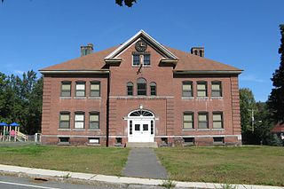
The Old Town Center Historic District is a historic district roughly along Locust Public Rd. and Salt Pond Road in Eastham, Massachusetts. The district encompasses Eastham's original town center, with a cluster of well-preserved 18th- and 19th-century buildings. The area served as the town's civic center due to its proximity to Salt Pond, which provided access to the Atlantic Ocean, and was a major transportation route. The advent of the railroad in the 1870s shifted the town's economic and civic heart to the present center. The Old Town district is 40 acres (16 ha) in size, with 42 mainly residential buildings contributing to its significance. The oldest building in the district is the c. 1672 John Knowles House at 191 Locust Road. The town's first town hall (1851) and first schoolhouse (1869) still stand in the district; the schoolhouse is a landmark visible from Route 6.

The Five Corners Historic District is a historic district encompassing the central district of the village of South Williamstown, Massachusetts. It is centered at the junction of Cold Spring, Green River, New Ashford. The junction has been a prominent center in the area since 1760. Prominent buildings in the district include the South Center School, the Store at Five Corners, and the Second Congregational Church. The district was listed on the National Register of Historic Places in 1993.

North Becket Village Historic District is a historic district encompassing the historic village of North Becket in the Berkshire hill town of Becket, Massachusetts. The village developed rapidly as the main economic and civic center of the town in a 20-year period beginning in 1841 with the arrival of the Western Railroad, and retains many fine examples of Greek Revival architecture. It was listed on the National Register of Historic Places in 1988.

The Conway Center Historic District encompasses the historic village center of Conway, Massachusetts. The district is focused on Main Street, a section of Massachusetts Route 116 that connects two major road intersections on either side of the South River. It includes properties on Main Street, Elm Street, and Academy Hill Road, and is generally representative of the growth of the community between about 1830 and 1930. The district was listed on the National Register of Historic Places in 1999.

The West Hatfield Historic District encompasses the historic rural village center of West Hatfield, Massachusetts. It is centered on the junction of West Street with Linseed Road and Church Avenue, and developed in the 19th century as a railroad-driven agricultural transportation center, populated mainly by immigrants. The district was listed on the National Register of Historic Places in 2005.
The Chester Factory Village Historic District is a historic district encompassing the historic village of Chester Factories in Chester, Massachusetts. Chester was settled in the 1760s, and the factory village was a location where water power was harnessed at an early time for grist mills and sawmills. The village got its name from the Chester Glass Factory, which operated in the area through the War of 1812. It benefited from the construction of a turnpike leading to Chester Center in 1804, and was transformed by the arrival of the railroad around 1840. The village became an important provisioning stop for trains, and the village further benefited by the fact that the railroad bypassed Chester Center. The economic and civic life of the town gradually shifted, and Chester Factories is where the town hall and library were built. It was added to the National Register of Historic Places in 1989.

The Russell Center Historic District is a historic district encompassing the historic village center of Russell, Massachusetts. It is centered at the junction of Main Street and Lincoln Avenue, and is bordered by the Westfield River to the east, and the rising foothills of The Berkshires to the west. The village's 19th century development was spurred by the railroad and sustained by local papermaking businesses. It was listed on the National Register of Historic Places in 1996, and was named as one of the 1,000 places to visit in Massachusetts by the Great Places in Massachusetts Commission.

The Shirley Village Historic District encompasses the main commercial and industrial village of Shirley, Massachusetts. It is located in the southern part of the town, and grew up around a series of mills that were located along Catacoonamug Brook, and then the railroad, which was built through the area in the 1840s. The district contains 441 properties. It is roughly bounded by Center, Harvard, Leominster and Shaker Roads. The district was listed on the National Register of Historic Places in 1992.

The Winchester Center Historic District encompasses the commercial and civic heart of Winchester, Massachusetts. It is roughly bounded Mt. Vernon and Washington Streets, Waterfield Road, Church and Main Streets. The district includes a number of Romanesque Revival buildings, including Winchester Town Hall and the Winchester Savings Bank building on Mount Vernon Street. Noted architects who contributed to the district include Robert Coit and Asa Fletcher. The district was listed on the National Register of Historic Places in 1986.
Eastham Public Library is the public library of Eastham, Massachusetts that has been serving the community for over 130 years. It provides a collection of print, non-print, and electronic resources for the community. The Eastham Public Library is a part of the Cape Libraries Automated Materials Sharing library network on Cape Cod and the Islands.

The McKenna Cottage is a historic house on Windmill Hill Road in Dublin, New Hampshire. It was originally built about 1889 as a single-story wing of the nearby Stonehenge estate house. It is a good example of Shingle style architecture, and one of the town's surviving reminders of the turn-of-the-century summer estate period. The house was listed on the National Register of Historic Places in 1983.

Shaftsbury Center is an unincorporated village in the town of Shaftsbury in Bennington County, Vermont, United States. Located on Vermont Route 7A at West Mountain and Tunic Roads, near the town's geographic center, it was the town's main civic center through the middle of the 19th century. It is now a modest village with agricultural and tourist-oriented economic interests. Most of the village is listed on the National Register of Historic Places as the Center Shaftsbury Historic District.

The Randolph Center Historic District encompasses the historic early town center of Randolph, Vermont. Established in 1783, it was later eclipsed by Randolph Village, which developed around the town's main railroad depot. The village now has a distinguished array of late 18th and early 19th-century architecture and is home to an academic campus now housing Vermont State University. It was listed on the National Register of Historic Places in 1974.

The Rockwood Road Historic District encompasses a portion of the town center of Norfolk, Massachusetts that has retained significant 19th-century characteristics. It extends along Rockwood Road from the MBTA Commuter Rail line to Boardman Street. This area consists mainly of residential or former residential buildings, as well as the 1863 Norfolk Grange Hall, a former church, and is reflective of the center's growth as a railroad village. The district was added to the National Register of Historic Places in 2017.


