
The Cape Cod National Seashore (CCNS) encompasses 43,607 acres on Cape Cod, in Massachusetts. CCNS was created on August 7, 1961, by President John F. Kennedy, when he signed a bill enacting the legislation he first co-sponsored as a Senator a few years prior. It includes ponds, woods and beachfront of the Atlantic coastal pine barrens ecoregion. The CCNS includes nearly 40 miles (64 km) of seashore along the Atlantic-facing eastern shore of Cape Cod, in the towns of Provincetown, Truro, Wellfleet, Eastham, Orleans and Chatham. It is administered by the National Park Service.
Eastham is a town in Barnstable County, Massachusetts, United States, Barnstable County being coextensive with Cape Cod. The population was 5,752 at the 2020 census.

The Bolton Center Historic District is the historic center of the town of Bolton, Massachusetts. The district encompasses what is essentially a linear town center, strung out principally along Main Street, with a well-preserved collection of residential and civic architecture spanning more than two centuries. The district was listed on the National Register of Historic Places in 1996.

The Cape Cod Rail Trail (CCRT) is a 25.5-mile (41.0 km) paved rail trail located on Cape Cod in Massachusetts. The trail route passes through the towns of Yarmouth, Dennis, Harwich, Brewster, Orleans, Eastham, and Wellfleet. It connects to the 6-plus mile (10 km) Old Colony Rail Trail leading to Chatham, the 2 mile Yarmouth multi-use trail, and 8 miles (13 km) of trails within Nickerson State Park. Short side trips on roads lead to national seashore beaches including Coast Guard Beach at the end of the Nauset Bike Trail in Cape Cod National Seashore. The trail is part of the Claire Saltonstall Bikeway.
This is a list of historic sites in Framingham, Massachusetts. There are several notable historic sites in Framingham, according to the Framingham Historical Society. This local society asserts:
While there are many historic spaces in Framingham, the Centre Common is the focal point for the town's past. Three of the town's most historic buildings on the Centre Common face "demolition by neglect." The Village Hall, the Edgell Memorial Library, and the Old Academy building not only house over 10,000 artifacts spanning four centuries of the town's history, but they are symbols of Framingham's commitment to educational excellence, civic engagement, and community pride.

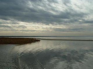
The Nauset Archaeological District is a National Historic Landmark District in Eastham, Massachusetts. Located within the southern portion of the Cape Cod National Seashore, this area was the location of substantial ancient settlements since at least 4,000 BC.

The Lunenburg Historic District is a historic district encompassing the historic center of Lunenburg, Massachusetts. The district is centered on a stretch of Main Street which connects two triangular intersections. It includes many of the town's oldest buildings, including the c. 1724 Cushing House, and the c. 1730 Stillman Stone House. Three of the town's most significant institutional buildings were built before 1850: the town hall, the Congregational church, and the Methodist church. The district was added to the National Register of Historic Places in 1988.

The Brewster Old King's Highway Historic District is a historic district encompassing much of Massachusetts Route 6A and portions of some adjacent roads in Brewster, Massachusetts, which was known as the Old King's Highway during colonial times. The center of Brewster grew around the junction of the Old King's Highway and Harwich Road, with its first church built there in 1700, and a nearby burying ground established in 1707. The civic and commercial functions of the town were spread along the Old King's Highway through the 19th and into the early 20th century. This concentration of historic resources extends about 1.5 miles (2.4 km) west of the main junction, and about 1.2 miles (1.9 km) eastward.

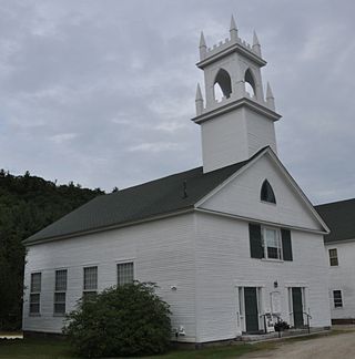
The Eastham Center Historic District is a historic district encompassing the main village center of Eastham, Massachusetts. This village center grew around the railroad station, which was built in 1870. The arrival of the railroad resulted in a shift of economic and civic activity from the old town center, a short way to the north. Prominent buildings in the district include the Town Hall, a Colonial Revival structure built in 1912, the Library, built in 1897, and the Universalist Chapel, built 1889. The main focal point of the district is Windmill Park, location of the Eastham Windmill, built c. 1680 and moved to Eastham in the 1790s; it is the oldest windmill on Cape Cod. The district was added to the National Register of Historic Places in 1999.

Becket Center Historic District is a historic district encompassing the historic early center of Becket, Massachusetts. Centered at the junction of Massachusetts Route 8 and YMCA Road, this area was the town's civic heart and a center of industry until it was eclipsed in importance by North Becket, which was served by the railroad. Most of the architecture in the district is in the Federal and Greek Revival styles popular in the late 18th to mid 19th centuries. The district was added to the National Register of Historic Places in 1982.

The Upper Historic District is a historic district encompassing the historic center of Washington, Massachusetts. Centered on the junction of Washington Mountain Road and Branch Road, the town center flourished from the town's establishment in the 1750s until the center of the town's business moved closer to the newly lain railroad in the 1830s. The district includes the old town hall, cemetery, common, and pound, as well as a number of residences. A meeting house (church) and schoolhouse once stood in the area, but the 1792 church was destroyed by lightning in 1859, and the schoolhouse is no longer extant. The district was added to the National Register of Historic Places in 1987.

The Ashfield Plain Historic District is a historic district roughly, along Main and South Streets and adjacent parts of Buckland and Norton Hill Roads in Ashfield, Massachusetts. It encompasses the village center of the town, which has acted as a civic and commercial center since the late 18th century. Its architectural heritage dates back to that time, but is now dominated by buildings from the late 19th and early 20th centuries. The district was listed on the National Register of Historic Places in 1991.

The West Granville Historic District is a historic district encompassing the center of West Granville, Massachusetts. The village is composed mainly of buildings form the late 18th and early 19th centuries, including an 18th-century church and 1830s academy building. The district was listed on the National Register of Historic Places in 1991.

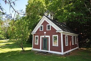
The Bournedale Village School is a historic school building at 29 Herring Pond Road in Bourne, Massachusetts. Built in 1897, it was the last one-room schoolhouse built by the town, and is one of the few surviving 19th-century schoolhouses in all of Barnstable County. It was listed on the National Register of Historic Places in 2013. The building is now used by the Bournedale Civic Association as a meeting space.

The East Andover Village Center Historic District encompasses the historic village center of East Andover, New Hampshire, United States. The 2.2-acre (0.89 ha) district includes a cemetery and three buildings: the Andover Congregational Church, the Highland Lake Grange Hall, and the East Andover Schoolhouse. It is located at the corner of New Hampshire Route 11 and Chase Hill Road. The district is unified by the appearance of the three buildings, and their styling, which is predominantly vernacular 19th century.

The Jaffrey Center Historic District encompasses the traditional civic heart of the small town of Jaffrey, New Hampshire. The district lies to the west of the Jaffrey's main business district, extending along Main Street from Harkness Road to the Jaffrey Common, and along Thorndike Pond Road northward from Main Street. It includes the town's oldest civic buildings, and was its main center until the mills of East Jaffrey eclipsed it. The district was listed on the National Register of Historic Places in 1975.
The Washington Common Historic District encompasses a cluster of three civic buildings and the town common in the center of Washington, New Hampshire. The town common began as a 2-acre (0.81 ha) parcel acquired in 1787, and the current town hall followed in 1789. It is a two-story wood-frame building which originally served as both a civic and religious meeting house. The adjacent Gothic Revival Congregational Church was built in 1840. The third structure is the Schoolhouse, a 2+1⁄2-story two-room school built in 1883. The district was listed on the National Register of Historic Places in 1986.
The Middletown Rural Historic District encompasses an area that was once the town center of Grafton, Vermont. Located northwest of Grafton Village along Middletown Road and adjacent roads, it includes nine well-preserved 19th-century properties, as well as the town's first cemetery and animal pound. The district was listed on the National Register of Historic Places in 2011.
The Rollinsford Grade School is a historic school building at 487 Locust Street in Rollinsford, New Hampshire. Opened in 1937, and still in use as an elementary school, it was the first school building commissioned by the prominent Durham firm Huddleston & Hersey, whose principal, Eric T. Huddleston, designed many buildings for the University of New Hampshire as the first campus architect. The grounds of the school are also notable as the burial site of Obo II, considered the father of the American Cocker Spaniel breed of dog. The property was listed with statewide significance on the National Register of Historic Places in 2015.

The Berkley Common Historic District is a historic district encompassing the historic heart of Berkley, Massachusetts. The town's village center is located near its geographic center, roughly midway between Massachusetts Route 24 and the Taunton River. Its central focus is the triangular town common, bounded by Main, Locust, and Porter Streets. The common is flanked by a number municipal and civic buildings, and has been the town's focus of civic life for more about 275 years.


