Elm Grove, Cherokee County, Texas | |
|---|---|
 Elm Grove  Elm Grove | |
| Coordinates: 31°52′19″N95°06′05″W / 31.8718375°N 95.1013317°W | |
| Country | United States |
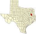
| State | Texas |
| County | Cherokee |
| Elevation | 351 ft (107 m) |
| Time zone | UTC-6 (Central (CST)) |
| • Summer (DST) | UTC-5 (CDT) |
| Area codes | 430 & 903 |
| GNIS feature ID | 1378256 [1] |
Elm Grove is an unincorporated community in Cherokee County, Texas, United States. [1] According to the Handbook of Texas, the community had a population of 50 in 2000. It is located within the Tyler-Jacksonville Micropolitan area.