Weeping Mary, Texas

Last updated
Weeping Mary, Texas
USA Texas location map.svg
Red pog.svg
Weeping Mary
Location within the state of Texas
Usa edcp location map.svg
Red pog.svg
Weeping Mary
Weeping Mary (the United States)
Coordinates: 31°35′49″N95°9′35″W / 31.59694°N 95.15972°W / 31.59694; -95.15972 Coordinates: 31°35′49″N95°9′35″W / 31.59694°N 95.15972°W / 31.59694; -95.15972
Country United States
State Texas
County Cherokee
Government
  TypeUnincorporated Town
Elevation
226 ft (69 m)
Population
 (2000)
  Total40
Time zone UTC-6 (Central (CST))
  Summer (DST) UTC-6 (CDT)
GNIS feature ID1370986 [1]

Weeping Mary is an unincorporated community in Cherokee County, Texas, United States. It is significant as the community closest to the ancient Caddo Mounds State Historic Site. [2]

Contents

History

EF3 damage to the Caddo Mounds State Historic Site museum in Weeping Mary. One person was killed here, and several others were injured. WeepingMaryEF3TX2019.jpg
EF3 damage to the Caddo Mounds State Historic Site museum in Weeping Mary. One person was killed here, and several others were injured.

Weeping Mary was founded by recently freed slaves shortly after the Civil War. The community later founded a Baptist church. The community had a few scattered houses in the 1930s and gained a church in 1990. Demographic changes took place after a boll weevil infestation destroyed the cotton crops, and mechanization reduced the need for farm labor. Many people left in the Great Migration, seeking jobs on the West Coast, especially during and after World War II, when more defense industry jobs were available. The population was 40 in 2000.

On April 13, 2019, an EF-3 tornado struck the community, destroying several homes and the Caddo Mounds museum, killing two people and injuring 20 others. [3]

Urban legends about the name

There are two known legends about how Weeping Mary got its name. The first says that the name refers to Mary Magdalene crying at Jesus' tomb. In another version, the town was named for a former slave who cried after losing her land, as the government had promised it would not be taken away. [4]

Geography

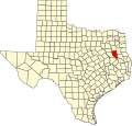
Weeping Mary is located at the intersection of Texas State Highway 21 and Farm to Market Road 2907, 18 mi (29 km) west of Rusk and 6.5 mi (10.5 km) southwest of Alto in southern Cherokee County. [5]

Education

The community founded a local school for their children in 1896 and had a record of 40 pupils. It was still operational in the 1930s. Students living in Weeping Mary are within the Alto Independent School District. [6]

Related Research Articles

<span class="mw-page-title-main">Cherokee County, Texas</span> County in Texas, United States

Cherokee County is a county located in the U.S. state of Texas. As of the 2020 census, its population was 50,412. The county seat is Rusk, which lies 130 miles southeast of Dallas and 160 miles north of Houston. The county was named for the Cherokee, who lived in the area before being expelled in 1839. Cherokee County comprises the Jacksonville micropolitan statistical area, which is also included in the Tyler–Jacksonville combined statistical area.

<span class="mw-page-title-main">Alto, Texas</span> Town in Texas, United States

Alto is a town in Cherokee County, Texas, United States. With a population of 1,027 at the 2020 U.S. census, Alto is the closest municipality to the Caddo Mounds State Historic Site, an archaeological site dating back to 800 CE, featuring a prehistoric village and ceremonial center.

<span class="mw-page-title-main">Caddo Mounds State Historic Site</span>

Caddo Mounds State Historic Site (41CE19) is an archaeological site in Weeping Mary, Texas. This Caddoan Mississippian culture site is composed of a village and ceremonial center that features two earthwork platform mounds and one burial mound. Located on an ancient Native American trail later named by the Spanish as El Camino Real de los Tejas, the settlement developed hundreds of years before the arrival of Europeans to the region. Archaeologists believe the site was created in approximately 800 CE, with most major construction taking place between 1100 and 1300 CE.

Forest is a community located in southeastern Cherokee County Texas, United States. According to the Handbook of Texas, the community had a population of 85 in 2000. It is located within the Tyler-Jacksonville combined statistical area.

Oakland is an unincorporated community in Cherokee County, located in the U.S. state of Texas. According to the Handbook of Texas, the community had a population of 50 in 2000. It is located within the Tyler-Jacksonville combined statistical area.

Salem is an unincorporated community in Cherokee County, located in the U.S. state of Texas. According to the Handbook of Texas, the community had a population of 20 in 2000. It is located within the Tyler-Jacksonville combined statistical area.

Linwood is an unincorporated community in Cherokee County, located in the U.S. state of Texas. According to the Handbook of Texas, the community had a population of 40 in 2000. It is located within the Tyler-Jacksonville combined statistical area.

Shady Grove is an unincorporated community in Cherokee County, located in the U.S. state of Texas. According to the Handbook of Texas, the community had a population of 30 in 2000. It is located within the Tyler-Jacksonville combined statistical area.

Gould is an unincorporated community in Cherokee County, located in the U.S. state of Texas. According to the Handbook of Texas, the community had a population of 20 in 2000. It is located within the Tyler-Jacksonville combined statistical area.

New Hope is an unincorporated community in Cherokee County, located in the U.S. state of Texas. According to the Handbook of Texas, the community had a population of 50 in 2000. It is located within the Tyler-Jacksonville combined statistical area.

Mound City, also known as Houston's Mound, is an unincorporated community in Houston and Anderson counties in the U.S. state of Texas. The Anderson County portion of the community located within the Palestine, Texas micropolitan area.

Mahl is an unincorporated community in Nacogdoches County, Texas. It is located on Highway 259 near the City of Nacogdoches.

Wheeler Springs is an unincorporated community in Houston County, Texas.

Elm Grove is an unincorporated community in Cherokee County, in the U.S. state of Texas. According to the Handbook of Texas, the community had a population of 50 in 2000. It is located within the Tyler-Jacksonville Micropolitan area.

Buena Vista is an unincorporated community in Bexar County, in the U.S. state of Texas. It is located within the Greater San Antonio metropolitan area.

Central High is an unincorporated community in Cherokee County, located in the U.S. state of Texas. According to the Handbook of Texas, the community had a population of 30 in 2000. It is located within the Tyler-Jacksonville combined statistical area.

Circle is an unincorporated community in Cherokee County, located in the U.S. state of Texas. According to the Handbook of Texas, there were no population estimates available for the community in 2000. It is located within the Tyler-Jacksonville combined statistical area.

Henry's Chapel is an unincorporated community in Cherokee County, located in the U.S. state of Texas. According to the Handbook of Texas, the community had a population of 75 in 2000. It is located within the Tyler-Jacksonville combined statistical area.

Pine Grove is an unincorporated community in Cherokee County, located in the U.S. state of Texas. According to the Handbook of Texas, the community had a population of 30 in 2000. It is located within the Tyler-Jacksonville combined statistical area.

Sweet Union is an unincorporated community in Cherokee County, located in the U.S. state of Texas. According to the Handbook of Texas, the community had a population of 40 in 2000. It is located within the Tyler-Jacksonville combined statistical area.

References

  1. U.S. Geological Survey Geographic Names Information System: Weeping Mary, Texas
  2. M., LONG, CHRISTOPHER and STANDIFER, MARY (2010-06-12). "CADDOAN MOUNDS STATE HISTORIC SITE". tshaonline.org. Retrieved 2016-12-19.
  3. "ArcGIS Web Application".
  4. CHRISTOPHER, LONG (2010-06-15). "WEEPING MARY, TX". tshaonline.org. Retrieved 2016-12-19.
  5. "Weeping Mary, Texas". Texas Escapes Online Magazine. Retrieved 2022-12-27.
  6. "Alto ISD :: School District Map of the Alto ISD :: MapTechnica". www.maptechnica.com. Retrieved 2016-12-19.