Emerald Express

Last updated
Emerald Express (EmX)
Green Line, Gateway Line
EmX logo.png
15101@EMX.jpg
Overview
Operator Lane Transit District
StatusOperational
Began serviceJanuary 14, 2007 (2007-01-14)
PredecessorsRoute 11 Thurston
Route
Route type Bus rapid transit
Locale Eugene and Springfield, Oregon
StartCommerce Station
ViaWest 11th Avenue, Franklin Boulevard, Pioneer Parkway
End Gateway Mall
Length13 miles (21 km)
Stations37
Service
Frequency10–20 minutes
Weekend frequency15–30 minutes
Timetable LTD Route 103 (EMX)
 {{{previous_line}}} {{{system_nav}}} {{{next_line}}} 

The Emerald Express (EmX) is a bus rapid transit (BRT) system in the Eugene-Springfield metropolitan area in Oregon, United States. It is provided by the Lane Transit District (LTD) which is the public transit authority in Lane County, Oregon.

LTD chose bus rapid transit after a review process in which several transportation options, including light rail, were considered. It was decided that the BRT option was the best fit for Eugene-Springfield's size and current transportation needs.

The first route, named the Green Line, was opened in early 2007, connecting downtown Springfield to downtown Eugene. There are ten stops along the 4-mile (6.4 km) route, including the University of Oregon.

Less than a year later, ridership had doubled in the corridor, and the city of Eugene was nominated for the 2008 Sustainable Transportation Award, and received an honorable mention. [1] An extension was opened on January 9, 2011, connecting EmX to the Gateway Mall as well as Sacred Heart Medical Center at RiverBend and International Way. [2] A second extension to West Eugene opened on September 17, 2017, adding 9 miles (14 km) to the system.

The Institute for Transportation and Development Policy (ITDP), under its BRT Standard, has given the EmX corridor a Bronze ranking. [3]

Description

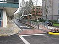
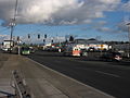
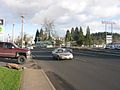
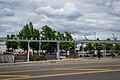
The EmX system is made up of sections of dedicated bus lanes for most of the route (60%), with normal roads in between. The vehicles are given signal priority via ground-loop signaling to the traffic control system, with special traffic signals at intersections. The vehicles have two sets of doors on the left and three on the right, allowing loading from platforms on either side. Most of the right hand side platforms can only accommodate the rear two doors. Riding the Emerald Express was free when it began operations, but now costs regular fare. The articulated buses are equipped with Hybrid drives which allows for a smooth acceleration from stops and through the various road segments.

On weekdays, service runs approximately from 6:00 am to 11:00 pm. Buses arrive every 10 minutes throughout the day, with longer headways during the evening and the first hour of the morning. More limited service operates during the weekend. [4]

Eugene-EMX-2.jpg
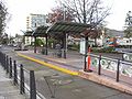
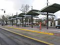
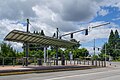
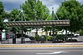
EmX buses at Agate Station, with dedicated busway visible at right

Fares

EmX fares are the same as other LTD bus routes; both single-ride ($1.75) and passes ($3.50 daily, $50 monthly) are accepted.

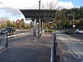
Unlike other LTD bus routes, the EmX uses a proof-of-payment system, and fares must be paid prior to boarding at ticket vending machines located on station platforms. [5] [6]

Lines

Green Line

The first EmX line, the Franklin Corridor (Green Line), opened on January 14, 2007. [7] It runs between Eugene Station in downtown Eugene and Springfield Station in downtown Springfield, and serves the University of Oregon. It is 4 mi (6.4 km) long and cost $25 million to design and build. [8] [9]

Compared with the non-BRT service that the Green Line replaced (Route 11), rush hour travel times decreased over 25% from 22 minutes to 16 minutes and ridership doubled in the first year. [1] In fiscal 200809, Green Line ridership was 1.6M. [10]

Local artist Linn Cook was selected by a committee of artists and community members to create cast and formed metal railings depicting indigenous plants. Each station features a different plant.

Gateway Line

The 7.8 mi (12.6 km) Gateway Line extension opened on January 9, 2011, linking downtown Springfield and Sacred Heart Medical Center at RiverBend. It uses the newly constructed Pioneer Parkway corridor and newly-constructed dedicated bus lanes on Martin Luther King Jr. Parkway and RiverBend Drive. [11]

West Eugene Extension

The West Eugene Extension added 17 stations west of Eugene Station. It opened on September 17, 2017. [12] [13]

LTD conducted environmental analyses and collected public comments as part of the extension's planning process. [14] A number of route alignments were considered, focusing on West 6th, 7th, or 13th Avenues to connect with West 11th Avenue somewhere near Chambers or Garfield Streets. One alternative placed service on West 7th Place instead of West 11th Avenue between Garfield and Seneca Rd. All alternatives continued down West 11th Avenue to a planned terminus and turnaround in the Walmart parking lot west of Commerce Street. [15] In spring 2011, the west 6th and 7th to 11th was selected as the locally preferred alternative.

Some local businesses and residents opposed the extension, saying that it would be expensive, unnecessary, and could cause a decrease in property values. [16] In June 2013, opponents of the extension filed suit in federal court in Seattle, challenging the extension's approval and funding by the Federal Transit Administration. The suit alleged nine violations of the National Environmental Policy Act and alleged violations of the Administrative Procedure Act. The suit further claimed that LTD had not met requirements for federal funding. [17] The court ruled against the extension's opponents in July 2014, [18] and construction began in March 2015. [19] The Federal Transit Administration awarded $75 million to the project in September 2015, covering most of its $96.5 million total cost. [20]

Future

LTD eventually plans to run EmX along all main transportation corridors in the metro area. Their MovingAhead long-range plan includes expansion of EmX service on new corridors. As of 2019, the corridors under consideration for EmX or other expanded bus services are 30th Avenue to serve Lane Community College; Coburg Road; Highway 99; Martin Luther King Jr. Boulevard; and River Road. [21]

Stations

EmX Green Line
StationTypeLocationCoordinatesNotesPhoto
Commerce StationCW 11th Ave at Commerce St 44°02′53.5″N123°10′13.9″W / 44.048194°N 123.170528°W / 44.048194; -123.170528 Western terminus
BertelsenCW 11th Ave at Bertelsen Rd 44°02′52.9″N123°09′44.8″W / 44.048028°N 123.162444°W / 44.048028; -123.162444
Sam ReynoldsCW 11th Ave east of Sam Reynolds St 44°02′53.0″N123°09′22.5″W / 44.048056°N 123.156250°W / 44.048056; -123.156250
Bailey HillCW 11th Ave west of Bailey Hill Rd 44°02′52.9″N123°08′55.2″W / 44.048028°N 123.148667°W / 44.048028; -123.148667
Seneca StationCW 11th Ave west of Seneca Rd 44°02′52.6″N123°08′28.3″W / 44.047944°N 123.141194°W / 44.047944; -123.141194 Seneca Central Shopping Center
Oak PatchCW 11th Ave at Oak Patch Rd 44°02′52.5″N123°08′08.5″W / 44.047917°N 123.135694°W / 44.047917; -123.135694
McKinleyCW 11th Ave at McKinley St 44°02′52.3″N123°07′47.8″W / 44.047861°N 123.129944°W / 44.047861; -123.129944
Garfield/11thCGarfield St north of W 11th Ave (Inbound only) 44°02′53.2″N123°07′23.3″W / 44.048111°N 123.123139°W / 44.048111; -123.123139
Garfield/10thCGarfield St south of 10th Ave (Outbound only) 44°02′54.0″N123°07′22.4″W / 44.048333°N 123.122889°W / 44.048333; -123.122889
Garfield/7thCGarfield St south of 7th Ave (Outbound only) 44°03′05.9″N123°07′21.7″W / 44.051639°N 123.122694°W / 44.051639; -123.122694
Garfield/6thCGarfield St south of 6th Ave (Inbound only) 44°03′11.6″N123°07′20.7″W / 44.053222°N 123.122417°W / 44.053222; -123.122417
Chambers StreetC6th Ave west of Chambers St (Inbound only), 7th Ave west of Chambers St (Outbound only)
Polk StreetC6th Ave west of Polk St (Inbound only), 7th Ave west of Polk St (Outbound only)
Monroe StreetC6th Ave west of Monroe St (Inbound only), 7th Ave east of Monroe St (Outbound only)
Charnelton StreetCCharnelton St south of 6th Ave (Inbound only), Charnelton St south of 7th Ave (Outbound only) 44°03′07.7″N123°05′44.8″W / 44.052139°N 123.095778°W / 44.052139; -123.095778
Eugene C10th Ave at Olive St 44°02′55.1″N123°05′37.3″W / 44.048639°N 123.093694°W / 44.048639; -123.093694 LTD Bus Station, Bays T and U EmX pulling into Eugene Station.jpg
High StreetM10th Ave at High St (Outbound only), 11th Ave at High Street (Inbound only) 44°02′55.7″N123°05′16.5″W / 44.048806°N 123.087917°W / 44.048806; -123.087917 EmX High Street Station.jpg
HilyardM11th Ave at Hilyard St 44°02′51.5″N123°04′56.5″W / 44.047639°N 123.082361°W / 44.047639; -123.082361 Sacred Heart Medical Center University District EmX Hilyard Station.jpg
Dads' GatesM11th Ave at Old Campus Lane 44°02′51.8″N123°04′39.3″W / 44.047722°N 123.077583°W / 44.047722; -123.077583 University of Oregon, West end of Campus EmX Dads Gates Station.jpg
AgateMFranklin Blvd at Agate St 44°02′47.2″N123°04′09.8″W / 44.046444°N 123.069389°W / 44.046444; -123.069389 At East end of University of Oregon Campus EMX Agate Street Station.jpg
WalnutMFranklin Blvd at Walnut St 44°02′41.2″N123°03′40.5″W / 44.044778°N 123.061250°W / 44.044778; -123.061250 EmX Walnut Station.jpg
GlenwoodCFranklin Blvd at Glenwood BlvdSeparate eastbound and westbound curbside platforms on opposite sides of the street Glenwood EmX.jpg
LexingtonCFranklin Blvd at Lexington AveSeparate eastbound and westbound curbside platforms on opposite sides of the street EmX Lexington Station one side.jpg
McVayMFranklin Blvd at Main St 44°02′39.1″N123°01′51.4″W / 44.044194°N 123.030944°W / 44.044194; -123.030944 EmX McVay Station.jpg
SpringfieldCS A St. at Pioneer Pkwy E 44°02′44.0″N123°01′18.8″W / 44.045556°N 123.021889°W / 44.045556; -123.021889 LTD Bus Station, Bays F and G EMX Platform G.jpg
E StreetCPioneer Pkwy W at E StSouthbound EMX E Street Station.jpg
F StreetCPioneer Pkwy E at F StNorthbound EMX F Street Station.jpg
CentennialMPioneer Pkwy at Centennial Blvd EMX Centennial Street Station.jpg
Q StreetMPioneer Pkwy at Q St EMX Q Street Station.jpg
Hayden BridgeMPioneer Pkwy at Hayden Bridge Way EMX Hayden Bridge Station.jpg
RiverBendMMartin Luther King Jr Pkwy at RiverBend Dr EMX RiverBend Station.jpg
Sacred HeartMRiverBend Dr at Cardinal Way Sacred Heart Medical Center at RiverBend South Entrance EMX Sacred Heart Station.jpg
Pavilion StationMSacred Heart Medical Center at RiverBend North Entrance
International Way EastMInternational Way EMX International Way East Station.jpg
Maple IslandMInternational Way at Maple Island Farm Rd, AKA International Center Station EMX International Center Station.jpg
International Way WestMInternational Way Symantec Corporation EMX International Way West Station.jpg
Kruse WayCGateway St at Kruse WaySeparate northbound and southbound curbside platforms on opposite sides of the street EMX Kruse Way Station.jpg
Postal WayCGateway St at Postal WaySeparate northbound and southbound curbside platforms on opposite sides of the street EMX Postal Way Station.jpg
GatewayCWest side of Gateway St., south of Oakdale Ave. 44°04′25.0″N123°02′33.8″W / 44.073611°N 123.042722°W / 44.073611; -123.042722 LTD Bus Station at Gateway Mall EMX Gateway Station.jpg
Guy LeeCHarlow Rd at Guy Lee ParkSeparate northbound and southbound curbside platforms on opposite sides of the street EMX Guy Lee Station.jpg
PheasantCHarlow Rd at Pheasant BlvdSeparate northbound and southbound curbside platforms on opposite sides of the street EMX Pheasant Station.jpg
Type Code: C = Curbside (side platforms) or M = Median (island platform)

Related Research Articles

<span class="mw-page-title-main">Lane Transit District</span>

The Lane Transit District (LTD) is a public agency that provides public transportation in Lane County, Oregon, United States. The transit district serves the Eugene and Springfield metropolitan areas, including the neighboring cities of Coburg, Junction City, Creswell, Cottage Grove, Veneta, and Lowell. LTD began service in 1970 with 18 buses and two vans, and today carries roughly 10.5 million customers annually with a fleet of 111 buses. Many of LTD's riders are students; University of Oregon and Lane Community College students ride by simply showing their student I.D. Student fees subsidize both programs, as well as limited late-night service until about 1 a.m. In 2022, the system had a ridership of 5,572,300, or about 19,600 per weekday as of the first quarter of 2023.

<span class="mw-page-title-main">Silver Line (MBTA)</span> Bus rapid transit system in Massachusetts, US

The Silver Line is a system of bus routes in Boston and Chelsea, Massachusetts, operated by the Massachusetts Bay Transportation Authority (MBTA). It is operated as part of the MBTA bus system, but branded as bus rapid transit (BRT) as part of the MBTA subway system. Six routes are operated as part of two disconnected corridors. As of 2019, weekday ridership on the Silver Line was 39,000.

<span class="mw-page-title-main">Miami-Dade Transit</span> Primary public transit authority of Miami, Florida

Miami-Dade Transit (MDT) is the primary public transit authority of Miami, Florida and the greater Miami-Dade County area. It is the largest transit system in Florida and the 15th-largest transit system in the United States. As of 2022, the system has 60,734,900 rides per year, or about 254,400 per weekday in the first quarter of 2023. MDT operates the Metrobus with their paratransit STS systems run by LSF. MDT also operates two rail transit systems: Metrorail and Metromover.

Metro Transit is the primary public transportation operator in the Minneapolis–Saint Paul area of the U.S. state of Minnesota and the largest operator in the state. Although Metro Transit is one of the smallest transit systems for a large metropolitan area in the United States, it has previously been ranked as one of the best. In 2022, the system had a ridership of 38,794,700, or about 123,900 per weekday as of the first quarter of 2023.

<span class="mw-page-title-main">Calgary Transit</span> Public transit service in Calgary, Alberta

Calgary Transit is the public transit agency which is owned and operated by the city of Calgary, Alberta, Canada. In 2019, an estimated 106.5 million passengers boarded approximately 1,155 Calgary Transit vehicles. It operates light metro (LRT), urban tramway, bus rapid transit (BRT), para-transit, and regular bus services. In 2022, the system had a ridership of 103,306,500, or about 382,800 per weekday as of the first quarter of 2023.

<span class="mw-page-title-main">Milwaukee County Transit System</span>

The Milwaukee County Transit System (MCTS) is the largest transit agency in Wisconsin, and is the primary transit provider for Milwaukee County. It ranks among the top 50 transit agencies in the United States for total passenger trips. Milwaukee Transport Services, Inc. is a quasi-governmental agency responsible for the management and operation of the Milwaukee County Transit System. Its bus fleet consists of 360 buses. In 2022, the system had a ridership of 15,914,000, or about 50,900 per weekday as of the first quarter of 2023.

<span class="mw-page-title-main">Regional Transportation District</span> Public transport agency in Denver, Colorado

The Regional Transportation District, more commonly referred to as RTD, is the regional agency operating public transit services in eight out of the twelve counties in the Denver-Aurora-Boulder Combined Statistical Area in the U.S. state of Colorado. It operates over a 2,342-square-mile (6,070 km2) area, serving 3.08 million people. RTD was organized in 1969 and is governed by a 15-member, publicly elected Board of Directors. Directors are elected to a four-year term and represent a specific district of about 180,000 constituents.

<span class="mw-page-title-main">Glenwood, Lane County, Oregon</span> Unincorporated community in the state of Oregon, United States

Glenwood is an unincorporated community in Lane County, Oregon, United States. Located between the cities of Springfield and Eugene, on the route of the former Pacific Highway, which is now named Franklin Boulevard. Glenwood is in Springfield's annexation and has a Eugene postal address.

<span class="mw-page-title-main">Metro Orange Line (Minnesota)</span> Minnesota bus line

The Metro Orange Line is a bus rapid transit line in the Twin Cities, Minnesota operated by Metro Transit. The line operates primarily along Interstate 35W from downtown Minneapolis through Richfield and Bloomington before terminating in Burnsville, Minnesota. The Orange Line provides access to 198,000 jobs with roughly a quarter of them outside downtown Minneapolis. The route serves a mix of stations located in the center of the highway, stations near highway exits, and on-street stations. The line has features typical of bus rapid transit systems with off-board fare payment, articulated buses with extra doors, stations with improved passenger amenities, and transit-only bus lanes on portions of the route.

<span class="mw-page-title-main">CT Fastrak</span> Bus rapid transit operations in Connecticut, USA

CTfastrak is a regional bus rapid transit system currently operating between downtown Hartford and Downtown New Britain station in New Britain in central Connecticut. Operated by Connecticut Transit, it is the first bus rapid transit system in Connecticut and the second in New England after the MBTA Silver Line. CTfastrak opened on March 28, 2015 after fifteen years of planning and three years of construction.

<span class="mw-page-title-main">HealthLine</span> Bus rapid transit line in Cleveland, Ohio

The HealthLine is a bus rapid transit (BRT) line run by the Greater Cleveland Regional Transit Authority in Cleveland and East Cleveland, Ohio, United States. The line runs along Euclid Avenue from Public Square in downtown Cleveland to the Louis Stokes Station at Windermere in East Cleveland. It began operation on October 24, 2008. Its current name was the result of a naming rights deal with the Cleveland Clinic and University Hospitals of Cleveland. The HealthLine is denoted with a silver color and abbreviated simply as HL on most RTA publications.

The transportation system of Oregon is a cooperation of complex systems of infrastructure.

<span class="mw-page-title-main">Metro (Minnesota)</span> Rapid transit network in the Minneapolis metropolitan area of the United States

Metro is a transit network in Minnesota serving the cities of Minneapolis and Saint Paul. It also provides service to some suburban areas. As of 2022 the system consists of two light rail lines and five bus rapid transit (BRT) lines all of which are operated by the local public transit company: Metro Transit. The five lines connect Downtown Minneapolis and St Paul with the Bloomington, Minneapolis-St Paul International Airport, Roseville, Richfield, Burnsville and Brooklyn Center.

<span class="mw-page-title-main">Metrobus (Miami-Dade County)</span>

The Metrobus network provides bus service throughout Miami-Dade County 365 days a year, operated by Miami-Dade Transit. It consists of about 93 routes and 893 buses, which connect most points in the county and part of southern Broward County as well. As of 2022, the system has 14,854,200 rides per year, or about 183,600 per day in the first quarter of 2023.

<span class="mw-page-title-main">Metro A Line (Minnesota)</span> Bus rapid transit line in the Minneapolis metropolitan area of the United States

The Metro A Line is a bus rapid transit line in the Twin Cities, Minnesota operated by Metro Transit. The A Line operates primarily along the Snelling Avenue corridor and travels through the cities of Minneapolis, Saint Paul, Falcon Heights, and Roseville. From the Blue Line in Minneapolis, the line travels past Minnehaha Park, through the Highland Village commercial area, past Macalester College, and connects to the Green Line near Allianz Field. The line continues through Saint Paul, past Hamline University, before traveling through Falcon Heights and Roseville, where the line passes the Minnesota State Fairgrounds, Har Mar Mall, and terminates at Rosedale Center.

<span class="mw-page-title-main">Metro C Line (Minnesota)</span> Bus rapid transit line in the Minneapolis metropolitan area of the United States

The Metro C Line is a bus rapid transit line in Brooklyn Center and Minneapolis, Minnesota operated by Metro Transit. The line is part of Metro Transit's Metro network of light rail and bus rapid transit lines. The route operates from the Brooklyn Center Transit Center along Penn Avenue and Olson Memorial Highway, terminating in downtown Minneapolis. The route is analogous to the existing Route 19 and is projected to increase ridership on this corridor from 7,000 to 9,000 by 2030. Eventually, part of its route will shift south to Glenwood Avenue from Olson Memorial Highway.

<span class="mw-page-title-main">Metro D Line (Minnesota)</span> Bus rapid transit line in the Minneapolis metropolitan area of the United States

The Metro D Line is a bus rapid transit line in Minneapolis-Saint Paul, Minnesota. The 18.5-mile (29.8 km) route primarily operates on Fremont and Chicago Avenues from Brooklyn Center through Minneapolis to the Mall of America in Bloomington. As part of BRT service, the D Line features "train-like amenities" including improved station facilities, off-board fare payment, modern vehicles, fewer stops, and higher frequency. The current alignment would substantially replace the existing Route 5, the highest ridership bus route in Minnesota.

<span class="mw-page-title-main">Tempo (bus rapid transit)</span> Bus service in Oakland and San Leandro, California

Tempo is a bus rapid transit (BRT) service in Oakland and San Leandro in California. It is operated by AC Transit as Line 1T. The route has dedicated lanes and center-boarding stations along much of the corridor, prepaid fares, signal preemption, and all-door boarding.

<span class="mw-page-title-main">CMAX</span> Bus rapid transit line in Columbus, Ohio

CMAX is a bus rapid transit (BRT) service in Central Ohio, operated by the Central Ohio Transit Authority (COTA). The line begins in Downtown Columbus, traveling northeast to Westerville. CMAX is Central Ohio's first bus rapid transit line; it began operation in 2018.

<span class="mw-page-title-main">FAX Q</span> Bus route in Fresno, California

FAX Q is a transit bus route, with some bus rapid transit features, operated by Fresno Area Express (FAX) in Fresno, California. The line began service on February 19, 2018, running from Woodward station near Woodward Park to Clovis Station along Blackstone Avenue and Ventura Avenue/Kings Canyon Road. Between the termini there are a total of 25 stations, two of which are major regional transit centers.

References

  1. 1 2 "London, Paris Edge Out Guatemala City, Guatemala; Eugene, Oregon; and Pereira, Colombia for 2008 Sustainable Transport Award", by Environmental Defense staff, Reuters News Service, Jan. 14, 2008
  2. "Search > Lane Transit District".
  3. "BRT Rankings". Institute for Transportation and Development Policy. 2020. Retrieved April 26, 2020.
  4. 101 "EmX Green Line" (schedule) Archived 2009-08-29 at the Wayback Machine , ltd.org, retrieved 6-29-09
  5. retrieved 11-28-2012
  6. "Lane Transit District - Fare & Pass Pricing". Lane Transit District. Retrieved 19 November 2018.
  7. RideSource “Free Fare” Zone Created by EmX
  8. Eugene, Oregon EmX, BRT Policy Center
  9. "EmX History". Lane Transit District. Retrieved 2009-04-08.
  10. "EmX FAQ, ltd.org, retrieved 9-1-2010
  11. "DeFazio in Driver's Seat for New EmX Line". Passenger Transport. American Public Transportation Association. January 31, 2011. Retrieved 2015-07-04.
  12. "EmX Service Begins in west Eugene" (Press release). Lane Transit District. September 17, 2017. Archived from the original on December 19, 2018. Retrieved December 19, 2018.
  13. Glucklich, Elon (September 17, 2017). "LTD delivers hustle to streets of bustle". The Register-Guard. Eugene, Oregon. Retrieved January 13, 2018.
  14. "West Eugene EmX Extension Project Schedule". Lane Transit District. Retrieved 2010-08-16.
  15. "Project Concept Maps". Lane Transit District. Retrieved 2010-08-16.
  16. "Concerns". Our Money Our Transit. Retrieved June 23, 2013.
  17. Bolt, Greg (June 23, 2013). "Foes sue to stop EmX growth". The Register-Guard. Eugene, Oregon: Guard Publishing Co. pp. B1. Retrieved June 23, 2013.
  18. Hill, Christian (July 18, 2014). "Challenge to bus line dismissed". The Register-Guard. Eugene, Oregon: Guard Publishing Co. Retrieved October 24, 2014.
  19. Hill, Christian (September 3, 2015). "Tree cutting heads west on new EmX line". The Register-Guard.
  20. Hill, Christian (September 11, 2015). "Feds award nearly $75 million for West Eugene Emx construction". The Register-Guard.
  21. Hill, Christian (October 14, 2019). "EmX bus service could be adding more transit lines in Eugene". The Register-Guard. Retrieved October 15, 2019.