Metro B Line (Minnesota)

Last updated

Metro B Line
Metro Minnesota logo.svg
C Line at 6th and Nicollet.jpg
The B Line would use 60-foot articulated buses similar to those used on the Metro C & D Lines. [1]
Overview
System Metro
Operator Metro Transit
Vehicle 60' Artic
StatusConstruction (Begin operation June 2025)
Predecessors 21, 53
Selby-Lake Streetcar
Route
Route type Bus rapid transit
Locale Minneapolis–St. Paul, Minnesota
StartWest Lake Station
Via Lake Street
End Union Depot
 {{{previous_line}}} {{{system_nav}}} {{{next_line}}} 

The Metro B Line is an under construction bus rapid transit route in Minneapolis and St. Paul. The route will operate mostly on Lake Street in Minneapolis before crossing the Mississippi River into St. Paul and operating mostly on Selby Avenue and ending in downtown St. Paul. The route was identified in Metro Transit's 2014 Arterial Transitway Corridors Study as one of eleven local routes to be upgraded to bus rapid transit. The route will have "train-like" features to speed up service, such as signal priority, all-door boarding, further stop spacing, and specialized vehicles. Planning and design was completed in 2021, with construction beginning in May 2023. The line will join a number of Metro Transit's future Metro system lines, as well as the currently operating A Line, C Line, and D Line. Full funding for the line was secured in October 2020 with a final $35 million from the state of Minnesota.

Construction on the line began in 2023 on the eastern portion of the line. The 2024 construction season is expected to focus on the western portion of the line with an opening in June 2025. [3]

Background

The corridor has a long history of transit service. The Twin City Rapid Transit Company operated a streetcar on Selby Avenue and Lake Street starting in 1906. [4] Once the streetcars were replaced in the 1950s with buses, a bus route continued to operate over the route. Route 21 serves the corridor from Uptown Transit Center to the Union Depot in downtown Saint Paul. A limited stop bus, Route 53, operates during peak periods offering limited stop service along Lake Street and Marshall Avenue before traveling on I-94 to downtown Saint Paul. Average speeds for Route 21 and 53 are 10 and 13.2 miles per hour respectively, which makes Route 21 one of the slowest routes in the Twin Cities. [5]

Buses on the corridor used to travel on the National Register of Historic Places-listed Selby Avenue Bridge over Ayd Mill Road. When the bridge was replaced in 1993, buses were detoured a half mile north to University Avenue. Increased ridership led Metro Transit to leave the detour in place following completion of the replacement bridge. [6] 10,000 rides are taken on Route 21 on weekdays which makes it the second highest ridership route for Metro Transit. [5]

In May 2019 the project was estimated to cost $54 million. [7] By October 2019 $16 million in funding had been identified from a competitive federal grant for a total of $26 million. [8] The line was fully funded after $35 million was included in the state bonding bill in October 2020. [9] [10]

Route

Project construction sign on Lake Street near West River Parkway. B Line construction sign on Lake Street.jpg
Project construction sign on Lake Street near West River Parkway.

In 2011-2012 Metro Transit studied eleven urban transit corridors to be upgraded with enhanced bus improvements. [11] Of the eleven, Route 21 was identified between West Lake Station and Snelling Avenue Station running on Lake Street in Minneapolis and Marshal Avenue in St. Paul with stations spaced a quarter mile to a half mile apart. [12] This concept plan connected Southwest LRT, METRO E Line, Orange Line, D Line, Blue Line, A Line, and Green Lines.

Stations

Under construction station looking west on Marshall Ave. Metro B Line station construction at Marshall Ave and Cleveland Ave.jpg
Under construction station looking west on Marshall Ave.

Stations as part of Metro Transit's aBRT (arterial bus rapid transit) service are unique to differentiate them service from local bus stops. Each station has a pylon marker that provides station identification, real time information, and audible departures. Unique shelters will have lighting, heating, emergency telephones and security cameras, and station areas will have seating, bike parking, and trash and recycling. To speed up boarding, platforms are raised 9 in (23 cm) from the pavement to facilitate near-level boarding though any door. Passengers pay before hand using Go-To card readers or ticket vending machines. [13]

At this time, only seven station pairs have been planned. West Lake Station will be constructed as part of the Southwest LRT project. The B Line will stop at or around Hennepin Avenue and Uptown Transit Station. A station at I-35W is being constructed as part of the Orange Line and 35W@94:Downtown to Crosstown projects. [14] In 2020, Hennepin County will reconstruct Lake Street between Blaisdell Avenue and 5th Avenue adding stations at Nicollet Avenue and 4th Avenue. [15] The B Line will also stop at or around Chicago Avenue and the Chicago-Lake Transit Center. The eastbound station at Midtown Station was constructed in 2017 as part of the South Minneapolis Regional Service Center, with the westbound station to be part of the Hi-Lake Interchange construction. [14] [16] On Snelling Avenue, stations would be shared at existing A Line stations. Specific station locations will be identified in 2020-2021 during the engineering phase. [17]

Metro B Line station locations and connecting routes
Station [18] Neighborhood(s) [19] [20] CityConnections [21]
West Lake StreetCedar Isles Dean, West Maka SkaMinneapolisRoute 17, Metro Green Line
Lake & Dean/West Bde Maka SkaCedar Isles DeanRoute 17
Lake & East Bde Maka SkaLagoon & East Bde Maka SkaCedar Isles Dean, East Bde Maka SkaRoute 17
Lake & Hennepin Lagoon & HennepinEast Isles, Lowry Hill East, South Uptown, East Bde Maka SkaRoutes 6, 17, 23, Metro E Line
Lake & Lyndale Lowry Hill East, Whittier, Lyndale, South UptownRoute 4
Lake & Nicollet Whittier, LyndaleRoute 18
Lake & I-35W Whittier, Phillips West, Central, Lyndale Metro Orange Line
Lake & 4th/5thPhillips West, CentralRoute 11
Lake & ChicagoPhillips West, Midtown Phillips, Powderhorn Park, CentralRoute 5, Metro D Line
Lake & BloomingtonMidtown Phillips, East Phillips, Powderhorn ParkRoute 14
Lake & Cedar East Phillips, Corcoran, Powderhorn ParkRoute 22
Lake Street/Midtown East Phillips, Longfellow, Corcoran Metro Blue Line
Lake & MinnehahaLongfellowRoute 7
Lake & 31st AveLongfellow
Lake & 36th AveLongfellowRoute 9
Lake & 44th AveCooper
Marshall & OtisUnion ParkSaint Paul
Marshall & CretinUnion ParkRoute 63
Marshall & ClevelandUnion ParkRoute 87
Marshall & FairviewUnion Park
Snelling & DaytonUnion Park Metro A Line
Selby & HamlineUnion Park
Selby & LexingtonUnion Park, Summit-UniversityRoute 83
Selby & VictoriaSummit-University
Selby & DaleSummit-UniversityRoute 65
Selby & Western-ArundelSummit-University
John Ireland & MarshallSummit-University
Smith Ave RampSmith & 5th StDowntown Saint Paul Metro Gold Line , many downtown bus routes
6th St & Washington StRice ParkDowntown Saint Paul Metro Gold Line , many downtown bus routes
6th St & Minnesota5th St & CedarDowntown Saint Paul Metro Green Line, Metro Gold Line , many downtown bus routes
6th St & Jackson5th St & Robert StDowntown Saint Paul Metro Gold Line , Metro G Line , many downtown bus routes
Union Depot & SibleyUnion Depot & WacoutaDowntown Saint Paul Metro Green Line, Metro Gold Line , many downtown bus routes
Saint Paul Union Depot Downtown Saint Paul Metro Green Line, Metro Gold Line , many downtown bus routes

    Selby Avenue extension

    An existing A Line station that will serve the B Line at Snelling & Dayton station in Saint Paul, Minnesota. Snelling & Dayton station, Saint Paul, Minnesota, January 2023.jpg
    An existing A Line station that will serve the B Line at Snelling & Dayton station in Saint Paul, Minnesota.

    In early 2019 project staff identified the possibility of extending the line past Snelling Avenue into downtown St. Paul via Selby Avenue. [22] Six routing options between Snelling Avenue and Lexington Parkway are under consideration. Of the six options, all would connect to the METRO A Line, while only two would connect to the METRO Green Line. In downtown, the B Line would share enhanced stations with the Metro Gold Line before terminating at Union Depot. [23]

    On October 28, 2019, it was publicly announced to the Transportation Committee of the Metropolitan Council that the route would extend past Snelling Avenue into downtown St. Paul. The recommended alignment does not have the route jog north of I-94 to connect to the METRO Green Line and Midway district of St. Paul. The rationale behind the decision was that more trips destined for the Lake Street-Marshall segment originated on Selby Avenue and downtown St. Paul than in Midway. The rationale also avoids congestion and delays that happen north of I-94, enabling more reliable travel times. Additionally, the B Line would have a direct north-south connection with the METRO A Line at Snelling & Dayton, which would fill the gap to the Midway district and METRO Green Line. [24] [8]

    See also

    Related Research Articles

    <span class="mw-page-title-main">Metro Blue Line (Minnesota)</span> Light rail line in Hennepin County, Minnesota

    The Metro Blue Line is a 12-mile (19.3 km) light rail line in Hennepin County, Minnesota, that is part of the Metro network. It travels from downtown Minneapolis to Minneapolis–Saint Paul International Airport and the southern suburb of Bloomington. Formerly the Hiawatha Line prior to May 2013, the line was originally named after the Milwaukee Road's Hiawatha passenger train and Hiawatha Avenue, reusing infrastructure from the former and running parallel to the latter for a portion of the route. The line opened June 26, 2004, and was the first light rail service in Minnesota. An extension, Bottineau LRT, is planned to open in 2028.

    Metro Transit is the primary public transportation operator in the Minneapolis–Saint Paul area of the U.S. state of Minnesota and the largest operator in the state. Although Metro Transit is one of the smallest transit systems for a large metropolitan area in the United States, it has previously been ranked as one of the best. In 2022, the system had a ridership of 38,794,700, or about 138,800 per weekday as of the third quarter of 2023.

    <span class="mw-page-title-main">Metro Green Line (Minnesota)</span> Light rail transit line in Minnesota, US

    The Metro Green Line is an 11-mile (18 km) light rail line that connects the central business districts of Minneapolis and Saint Paul in Minnesota as well as the University of Minnesota. An extension is under construction that will extend the line to the southwest connecting St. Louis Park, Hopkins, Minnetonka and Eden Prairie. The line follows the path of former Metro Transit bus route 16 along University Avenue and Washington Avenue. It is the second light-rail line in the region, after the Blue Line, which opened in 2004 and connects Minneapolis with the southern suburb of Bloomington.

    <span class="mw-page-title-main">Government Plaza station</span> Light rail station in Minneapolis, Minnesota

    Government Plaza station is a Metro light rail station on the Blue Line and Green Line in Minneapolis, Minnesota. The station is located on 5th Street South, between 3rd and 4th Avenues South in downtown Minneapolis. This station opened on June 26, 2004, with initial light rail service in the Twin Cities.

    <span class="mw-page-title-main">Lake Street/Midtown station</span> Light rail station in Minneapolis, Minnesota

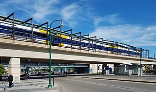
    Lake Street/Midtown station, also referred locally as either the Lake Street station or Midtown station, is a Blue Line light rail stop in Minneapolis, Minnesota, United States. The station is located on an bridge over East Lake Street adjacent to Highway 55.

    <span class="mw-page-title-main">Mall of America station</span> Light rail and bus station in Bloomington, Minnesota

    The Mall of America station is the busiest transit center in Minnesota, with bus and light rail service linking the Mall of America to many destinations in the Minneapolis–St. Paul metro. Public transit service is provided by Metro Transit and the Minnesota Valley Transit Authority. The station is served by Metro Blue Line and Red Line. The station previously hosted private shuttle services to hotels and Mystic Lake Casino until those services moved to a new charter bus terminal on the north side of the mall in 2015.

    <span class="mw-page-title-main">Lake Street (Minneapolis)</span>

    Lake Street is a major east-west thoroughfare between 29th and 31st streets in Minneapolis, Minnesota United States. From its western most end at the city's limits, Lake Street reaches the Chain of Lakes, passing over a small channel linking Bde Maka Ska and Lake of the Isles, and at its eastern most end it reaches the Mississippi River. In May 2020, the Lake Street corridor suffered extensive damage during local unrest following the murder of George Floyd. In August of the same year, city officials designated East Lake Street as one of seven cultural districts to promote racial equity, preserve cultural identity, and promote economic growth.

    <span class="mw-page-title-main">Snelling Avenue station</span> Light rail and bus rapid transit station in Saint Paul, Minnesota

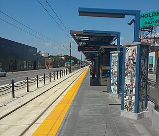
    Snelling Avenue station is a light rail station along the Metro Green Line in Saint Paul, Minnesota. It is located along University Avenue on either side of the intersection with Snelling Avenue. The station has split side platforms, with the westbound platform on the north side of the tracks west of Snelling and the eastbound platform on the south side of the tracks east of the intersection.

    The Riverview Corridor is a transit corridor connecting Downtown Saint Paul and the Mall of America in Bloomington via the Minneapolis-Saint Paul International Airport. The corridor serves an area from the Saint Paul Union Depot to the Mall via a route along West 7th Street, which runs southwest from Downtown Saint Paul. The corridor creates a triangle connecting opposite ends of the Blue Line and Green Line.

    <span class="mw-page-title-main">Metro Orange Line (Minnesota)</span> Minnesota bus line

    The Metro Orange Line is a bus rapid transit line in the Twin Cities, Minnesota operated by Metro Transit. The line operates primarily along Interstate 35W from downtown Minneapolis through Richfield and Bloomington before terminating in Burnsville, Minnesota. The Orange Line provides access to 198,000 jobs with roughly a quarter of them outside downtown Minneapolis. The route serves a mix of stations located in the center of the highway, stations near highway exits, and on-street stations. The line has features typical of bus rapid transit systems with off-board fare payment, articulated buses with extra doors, stations with improved passenger amenities, and transit-only bus lanes on portions of the route.

    <span class="mw-page-title-main">I-35W & Lake Street station</span>

    I-35W & Lake Street station is a bus rapid transit station along the Metro Orange Line and planned B Line bus rapid transit (BRT) routes in Minneapolis, Minnesota. In addition to the BRT services, the station is also served by Metro route 578, Minnesota Valley Transit Authority routes 460, 465, 467, 470, 472, 475 and 477, along with SouthWest Transit routes 600 and 695.

    <span class="mw-page-title-main">Metro (Minnesota)</span> Rapid transit network in the Minneapolis metropolitan area of the United States

    Metro is a transit network in Minnesota serving the cities of Minneapolis and Saint Paul. It also provides service to some suburban areas. As of 2022, the system consists of two light rail lines and five bus rapid transit (BRT) lines all of which are operated by the local public transit company: Metro Transit. The five lines connect Downtown Minneapolis and St Paul with the Bloomington, Minneapolis-St Paul International Airport, Roseville, Richfield, Burnsville and Brooklyn Center.

    <span class="mw-page-title-main">Metro A Line (Minnesota)</span> Bus rapid transit line in the Minneapolis metropolitan area of the United States

    The Metro A Line is a bus rapid transit line in the Twin Cities, Minnesota operated by Metro Transit. The A Line operates primarily along the Snelling Avenue corridor and travels through the cities of Minneapolis, Saint Paul, Falcon Heights, and Roseville. From the Blue Line in Minneapolis, the line travels past Minnehaha Park, through the Highland Village commercial area, past Macalester College, and connects to the Green Line near Allianz Field. The line continues through Saint Paul, past Hamline University, before traveling through Falcon Heights and Roseville, where the line passes the Minnesota State Fairgrounds, Har Mar Mall, and terminates at Rosedale Center.

    <span class="mw-page-title-main">Metro C Line (Minnesota)</span> Bus rapid transit line in the Minneapolis metropolitan area of the United States

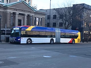
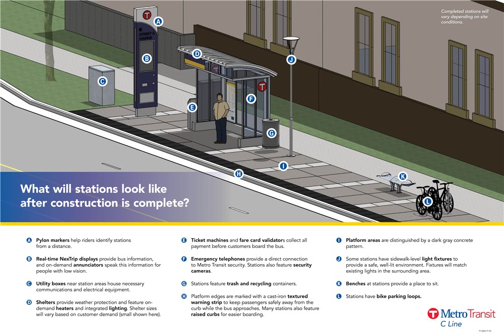
    The Metro C Line is a bus rapid transit line in Brooklyn Center and Minneapolis, Minnesota operated by Metro Transit. The line is part of Metro Transit's Metro network of light rail and bus rapid transit lines. The route operates from the Brooklyn Center Transit Center along Penn Avenue and Olson Memorial Highway, terminating in downtown Minneapolis. The route is analogous to the existing Route 19 and is projected to increase ridership on this corridor from 7,000 to 9,000 by 2030. Eventually, part of its route will shift south to Glenwood Avenue from Olson Memorial Highway.

    <span class="mw-page-title-main">Metro D Line (Minnesota)</span> Bus rapid transit line in the Minneapolis metropolitan area of the United States

    The Metro D Line is a bus rapid transit line in Minneapolis-Saint Paul, Minnesota. The 18.5-mile (29.8 km) route primarily operates on Fremont and Chicago Avenues from Brooklyn Center through Minneapolis to the Mall of America in Bloomington. As part of BRT service, the D Line features "train-like amenities" including improved station facilities, off-board fare payment, modern vehicles, fewer stops, and higher frequency. The current alignment would substantially replace the existing Route 5, the highest ridership bus route in Minnesota.

    <span class="mw-page-title-main">Metro E Line (Minnesota)</span> Bus rapid transit line in the Minneapolis metropolitan area of the United States

    The Metro E Line is a planned bus rapid transit route in Minneapolis, Saint Paul, and Edina. The route will operate from Southdale Center Transit Center in Edina, Minnesota to Westgate station in Saint Paul. Running mostly on France Avenue, Hennepin Avenue, and University Avenue, the line will serve major destinations such as Southdale Center, Fairview Hospital, 50th & France, Linden Hills, Uptown, Minneapolis Sculpture Garden, Downtown Minneapolis, Dinkytown, the University of Minnesota, and Prospect Park. The route will have "train-like" features to speed up service and improve reliability, such as signal priority, bus lanes, all-door boarding, further stop spacing, and specialized vehicles. In 2019 planning and design were underway, with construction slated for 2023 and operations beginning a year later but that timeline has been moved back. The E Line would largely replace Route 6 which carries 9,000 trips each weekday. The project was fully funded with $60 million by the state of Minnesota in 2021 and is expected to open in 2025.

    <span class="mw-page-title-main">Snelling & Dayton station</span> Bus station in Saint Paul, Minnesota, United States

    Snelling & Dayton is a bus rapid transit station on the Metro A Line in Saint Paul, Minnesota.

    <span class="mw-page-title-main">Ford & Kenneth station</span> Bus station in Saint Paul, Minnesota

    Ford & Kenneth is a bus rapid transit station on the Metro A Line in Saint Paul, Minnesota.

    <span class="mw-page-title-main">Ford & Finn station</span> Bus station in Saint Paul, Minnesota

    Ford & Finn is a bus rapid transit station on the Metro A Line in Saint Paul, Minnesota.

    References

    1. "B Line Frequently Asked Questions". www.metrotransit.org. Retrieved October 24, 2019.
    2. "B Line Project - Metro Transit". www.metrotransit.org. Retrieved October 18, 2019.
    3. Roth, Katie (September 25, 2023). "Arterial BRT Projects Update". Metropolitan Council Transportation Committee. Metro Transit. Retrieved November 2, 2023.
    4. Diers, John W.; Isaacs, Aaron (2007). Twin Cities by trolley : the streetcar era in Minneapolis and St. Paul. Minneapolis: University of Minnesota Press. ISBN   978-0-8166-4358-5.
    5. 1 2 Melo, Frederick (January 2, 2020). "Metro Transit's new B Line will extend to downtown St. Paul, a victory for transit advocates". St. Paul Pioneer Press . Retrieved September 5, 2020.
    6. Lindeke, Bill (April 16, 2019). "From streetcar to BRT: The return of the Selby-Lake transit corridor?". MinnPost . Retrieved September 5, 2020.
    7. Moore, Janet (May 8, 2019). "Ecolab CEO, St. Paul mayor and others tout proposed B Line rapid bus". Star Tribune. Retrieved September 5, 2020.
    8. 1 2 Thomas, Dylan (October 28, 2019). "Met Council gets behind a faster ride for St. Paul commuters". Minneapolis/St. Paul Business Journal. Retrieved September 5, 2020.
    9. Moore, Janet (October 22, 2020). "Two Twin Cities rapid bus lines win state funding". Star Tribune. Retrieved October 23, 2020.
    10. Melo, Frederick (October 26, 2020). "One of St. Paul's busiest bus routes will get a major upgrade". St. Paul Pioneer Press. Retrieved November 10, 2020.
    11. "ABRT Study - Metro Transit". www.metrotransit.org. Retrieved October 19, 2019.
    12. "Lake Street" (PDF). www.metrotransit.org. Retrieved October 19, 2019.
    13. "BRT Station Characteristic". www.metrotransit.org. Retrieved October 19, 2019.
    14. 1 2 "B Line Library - Metro Transit". www.metrotransit.org. Retrieved October 19, 2019.
    15. "Lake Street Reconstruction Phase 4 Project Fact Sheet" (PDF). Hennepin County. November 2016. Retrieved October 19, 2018.
    16. "Hiawatha-Lake Interchange Study". www.minneapolismn.gov. Retrieved October 22, 2019.
    17. "B Line Fact Sheet" (PDF). Metro Transit. April 29, 2019. Retrieved October 19, 2019.
    18. "METRO B Line Corridor Plan". Metro Transit. Retrieved October 2, 2022.
    19. "Minneapolis Neighborhood Map". City of Minneapolis. Retrieved August 21, 2022.
    20. "Saint Paul District Council and Ward Lookup". stpaul.maps.arcgis.com. City of Saint Paul. Retrieved October 2, 2022.
    21. "Schedules & Maps". Metro Transit. August 2022. Retrieved October 2, 2022.
    22. "The B Line rapid bus may replace Route 21 from Uptown Minneapolis to downtown St. Paul". Twin Cities. April 15, 2019. Retrieved October 19, 2019.
    23. "B Line Open House Boards" (PDF). www.metrotransit.org. June 6, 2019. Retrieved October 19, 2019.
    24. Roth, Katie (October 28, 2019). "METRO B Line Update and Preliminary Recommendations".
    Template:Attached KML/Metro B Line (Minnesota)
    KML is not from Wikidata