Metro C Line (Minnesota)

Last updated

Metro C Line
Metro Minnesota logo.svg
C Line Approaching Penn and Dowling Station.jpg
A northbound bus on Penn Avenue in North Minneapolis.
Overview
System Metro
Operator Metro Transit
GarageFred T. Heywood
VehicleNFI XD60, NFI XE60
StatusOperational
Began serviceJune 8, 2019
Predecessors Route 19
Parts of 6th Ave N, Glenwood, and Penn Streetcars
Route
Route type Bus rapid transit
Locale Minneapolis–St. Paul, Minnesota
StartBrooklyn Center Transit Center
ViaOlson Memorial Highway, Penn Avenue
EndDowntown Minneapolis
Length8.4 mi (13.5 km) [1]
Stations20 (4 station pairs downtown)
Service
LevelDaily
FrequencyEvery 10 minutes
Journey time31 minutes
Operates6:00am – 1:00am
Ridership6,850 (2019 avg. weekday) [2]
 {{{previous_line}}} {{{system_nav}}} {{{next_line}}} 

The Metro C Line is a bus rapid transit line in Brooklyn Center and Minneapolis, Minnesota operated by Metro Transit. The line is part of Metro Transit's Metro network of light rail and bus rapid transit lines. The route operates from the Brooklyn Center Transit Center along Penn Avenue and Olson Memorial Highway, terminating in downtown Minneapolis. The route is analogous to the existing Route 19 and is projected to increase ridership on this corridor from 7,000 to 9,000 by 2030. [3] Eventually, part of its route will shift south to Glenwood Avenue from Olson Memorial Highway. [4]

The C Line, along with the similarly built A Line, features fewer stops and modern bus stops with "train-like" amenities, including distinct stations and off-board fare payment. Additionally, the C Line features the Twin Cities' first battery-electric buses, built by New Flyer of America. [5] Construction on the C Line began in March 2018 and began revenue service on June 8, 2019. [4] [6] The week of November 25, 2019, the C Line surpassed one-million rides after only five months of operation. Average weekday ridership was 30% higher than Route 19 ridership before C Line construction. Average Saturday and Sunday ridership has increased 25% and 40%, respectively. [7]

Route

The northern terminus of the C Line is at Brooklyn Center Transit Center in Minneapolis suburb of Brooklyn Center. Station facilities include an indoor waiting area, restrooms, bike racks, and ticket vending machines and Go-To card readers for off-board fare collection. [8] Brooklyn Center Transit Center also has rapid chargers for battery-electric New Flyer buses, but as of October 15, 2019, electric buses have been pulled from service due to charging problems at their garage. [9] From there, the C Line begins traveling southbound along Xerxes with one stop at 56th Avenue, adjacent to the former site of Brookdale Mall. The line then continues south on Brooklyn Boulevard with a station at 51st Avenue before entering the City of Minneapolis, where Brooklyn Boulevard changes to Osseo Road. An infill station at 47th Avenue will be constructed between 2023 and 2025. [10] The C Line turns south onto Penn Avenue, splitting from the under construction Metro D Line, stopping the next block at 43rd Avenue. From there, the line stops every .25 miles (0.40 km) to .5 miles (0.80 km) serving North Minneapolis along Penn Avenue. At Olson Memorial Highway, the C Line turns east to head towards downtown Minneapolis with four station stops along the highway.

A Metro C Line bus heading northbound in the 7th Street bus lane installed in 2021. Metro C Line in the 7th Street bus lane.jpg
A Metro C Line bus heading northbound in the 7th Street bus lane installed in 2021.

The route enters downtown along 7th Street, which splits into one-way pairs; 8th Street southbound and 7th Street northbound. Southbound, three BRT stations are currently open, at Ramp A/7th Street Transit Center and 8th Street at Nicollet Mall and at 3rd/4th Avenues. Stations on 8th Street at Hennepin and Park Avenues will fully open at a later date, with buses still stopping there on request.[ needs update? ] [11] After the final stop at Park Avenue, buses continue to 11th Avenue where they layover and await the return trip northbound.

Heading northbound from downtown, the C Line begins its route at Park Avenue Station located under Hennepin County Medical Center and continues north on 7th Street. Stations are at 3rd/4th Avenues, Nicollet Mall, and Hennepin Avenue. These stations are Metro Transit's standard bus rapid transit stations with off-board fare collection, real-time information, and near-level boarding. After exiting downtown, the C Line follows the same route north to Brooklyn Center Transit Center. [12]

6th Street operations

Upon opening day, 8th Street in downtown Minneapolis was being reconstructed. [13] As a result, southbound buses were detoured onto Glenwood Avenue until 6th Street where they turned right and continued with temporary stops at Hennepin Avenue, Nicollet Mall, 3rd Avenue, and Park Avenue. These temporary stops do not include real time information or fare-collection systems, and riders could not board C Line buses at these stops without a valid transfer. In July 2019, another temporary stop southbound was added in downtown Minneapolis at 7th Street on Glenwood Avenue, analogous and a short distance to the Ramp A/7th Street Transit Center.

Buses were permanently routed to 8th Street December 7, 2019. [11]

Phase II Glenwood Avenue alignment

The Bottineau LRT Extension of the METRO Blue Line was planned to run down Olson Memorial Highway between downtown Minneapolis and Penn Avenue. Under Phase II, at the start of light rail service the C Line would move from Olson Highway to Glenwood Avenue about a quarter mile south. [14] The goal was to balance transit service across multiple corridors while retaining similar travel times. [15] In 2016, it was identified that there would be four stations on Glenwood Avenue at Morgan, Lyndale, Royalston, and between Cedar Lake Road and Dupont Avenues. At Penn Avenue and Olson Highway, a new station would be constructed south of Olson on Penn, moving it from its temporary stop location on Olson. [16]

As an interim service on Olson Memorial Highway, three stations (Penn, Humboldt, and Bryant) were not built as normal C Line stations. Shelters are standard Metro Transit shelters and there is no near-level boarding, however, concrete pads were constructed the entire length of a bus. Real time information is provided at these stations, but they lack the service's distinct pylon markers. These stations still have off-board fare collection vending machines and Go-To card readers. [17]

Negotiations with BNSF prevented the planned alignment from proceeding and the future, including the alignment, of the Bottineau Blue Line Extension is unclear. [18] In August 2020, the Metropolitan Council announced that the Bottineau Blue Line Extension would be looking for an alternative route to Brooklyn Park. Following the decision, Metro Transit is advancing planning for the Phase II alignment to be completed before the original 2024 opening of the light rail service. Stations at Penn, Lyndale, and Royalston have been coordinated with other public works projects. [19]

Additionally, in 2021 the Minnesota Legislature passed a bill that included $250,000 to analyze transit improvements from Medina, Minnesota to downtown Minneapolis, requiring options for bus rapid transit service to be included. [20] Initially studied in 2015, the line would follow the C Line's alignment on Olson Memorial Highway out of downtown Minneapolis, advancing the goal of balancing transit service across multiple corridors. [21]

Service

C Line frequency
TypeSpan of serviceFrequency
Early Weekdays5:00 a.m.  6:30 am15–30 minutes
Weekdays6:30 a.m.  7:00 pm10 minutes
Late Weekdays7:00 p.m.  1:00 am15–30 minutes
Saturday5:30 a.m.  1:30 am10–30 minutes
Sunday5:30 a.m.  1:30 am10–30 minutes

The C Line runs every 10 minutes during daytime service on weekdays and weekends, with reduced frequencies of up to 30 minutes in the early morning and late evening. [22] Route 19 was retained as 30-minute underlying bus service along the line. Select rush hour Route 19 trips are rerouted along Thomas Ave to serve areas previously served by terminal branches of Route 19. [23] Five months after opening the route in October 2019, combined ridership for Route 19 and the C Line was roughly 8,300 weekday rides. Previously the corridor served 7,000 weekday rides with just Route 19. [24] Ridership increased on weekdays by 30%, Saturdays by 25%, and Sundays by 40%, five months after opening. [7]

Stations

Station characteristics

A typical C Line station at 7th St & 3rd Ave. 7th St and 3rd Ave station Minneapolis 2019.jpg
A typical C Line station at 7th St & 3rd Ave.

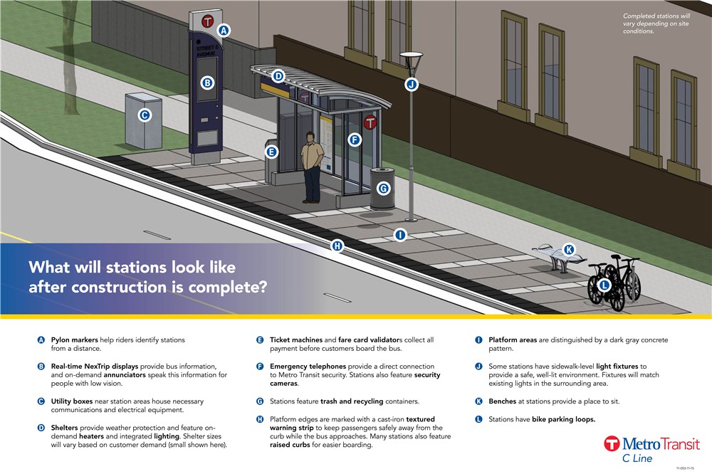
Stations on Metro Transit's bus rapid transit service are unique and have enhanced features to differentiate them from local bus stops. Station shelters follow a "kit-of-parts" design so they can be easily identified and used throughout the system. [25] There are three different station sizes–small, medium, and large–and the size chosen depends on daily boardings and site context. Stations have lighted canopies, on-demand heating, security cameras and emergency telephones, benches, and bike parking. Pavement in boarding areas are treated with a darker shade of concrete to delineate them from the sidewalk. Ticket vending machines and Go-To card readers are located on platforms for off-board fare collection, speeding up the boarding process and reducing bus dwell time. Each station has a pylon marker that provides real-time bus arrival information and station identification. Illuminated signage at the top of the station blinks when a bus is one minute away. Curbs at stations have tactile warning strips and are raised 9 in (23 cm) from the road surface, facilitating near-level boarding to speed up and make boarding easier. [26]

Penn, Humboldt, and Bryant stations on Olson Memorial Highway were designed to be temporary and use standard Metro Transit shelters, but still have real time information and off-board fare collection. It was planned to have the Blue Line extension operate on Olson Memorial Highway, and upon its opening would have shifted the C Line's route south to Glenwood Avenue, where permanent stations would be constructed. Upon opening, the five southbound stops on 6th Street in downtown Minneapolis were drop-off only until the route permanently moved to 8th Street when construction was complete. These stops had no features or amenities due to their temporary use.

List of stations

Metro C Line battery electric bus charging during layover at Brooklyn Center Transit Center. METRO C Line electric bus charging at BCTC (side).jpg
Metro C Line battery electric bus charging during layover at Brooklyn Center Transit Center.
Station [12] Neighborhood(s)CityOpenedConnectionsFall 2019 weekday C Line boardings [27]
Brooklyn Center Transit Center Centennial Brooklyn Center June 8, 2019Routes 5, 19, 22, 717, 721, 722, 723, 724, 761, 762, 801334
Xerxes & 56th AvenueRoutes 5, 19, 22, 717, 721, 724, 761256
Brooklyn & 51st AvenueHappy HollowRoutes 5, 19, 22, 32, 721, 724, 76176
Osseo & 47th Avenue Victory Minneapolis Infill station; 2023-2025 openingRoute 19-
Penn & 43rd AvenueJune 8, 2019Route 19221
Penn & Dowling Cleveland, Folwell, Victory, Webber-Camden Route 19179
Penn & 36th AvenueCleveland, FolwellRoute 19310
Penn & Lowry [lower-alpha 1] Cleveland, Folwell, Jordan Routes 19, 32549
Penn & 29th AvenueJordanRoutes 19, 32188
Penn & West BroadwayJordan, Willard-Hay Routes 14, 19402
Penn & Golden ValleyWillard-HayRoutes 14, 19, 30408
Penn & Plymouth Near-North, Willard-HayRoutes 7, 19, 32376
Olson & Penn Harrison, Near-North, Willard-HayRoutes 19, 755279
Olson & HumboldtHarrison, Near-NorthRoute 19197
Olson & Bryant Sumner-Glenwood Route 19209
7th Street & Olson/5th Avenue North Loop Routes 5, 19, 22, 755292
Ramp A/7th Street Transit Center [lower-alpha 2] Downtown West December 7, 2019Many downtown routes26
7th Street & Hennepin8th Street & HennepinJune 8, 2019Early 2021Many downtown routes546
7th Street & Nicollet 8th Street & Nicollet December 7, 2019Many downtown routes, Nicollet Mall 1,127
7th Street & 3rd/4th Avenue8th Street & 3rd/4th AvenueMany downtown routes322
7th Street & Park8th Street & Park Elliot Park March 28, 2022Many downtown routes502
  1. Hosted opening day celebrations, with two inaugural buses running to Brooklyn Center and to Downtown Minneapolis. [28]
  2. Southbound service only

Fleet

A C Line New Flyer XE60 battery electric articulated bus in service in June 2020. C Line Departure.jpg
A C Line New Flyer XE60 battery electric articulated bus in service in June 2020.

The C Line has fourteen 60-foot articulated buses assigned to the route. Six buses are diesel XD60 models and eight are battery-electric XE60 models, the first electric articulated buses in Minnesota. [29] These buses were manufactured by New Flyer Industries in Saint Cloud, Minnesota and have three doors and wider aisles for faster boarding. [30] [31] The fleet is also equipped with transit signal priority, Quantum wheelchair securement, free WiFi, and USB chargers. Each bus was given a unique name by communities along the corridor. [32] The electric buses had an effective range of 120-140 miles depending on the weather but lost 40% of their range in the winter due to the cold weather. [33] [34] Diesel heaters help heat electric buses during cold weather. [35]

Electric buses on the route haven't always been available due to charging and mechanical issues. [36] Over the first 631 service days from opening until February 2021, there were only 10 days with every bus and charger available. [33] Due to issues with charging equipment at garages, all eight electric buses were temporarily removed from service in July 2019 and then again in October. [37] [38] Because of this, three Gillig BRTPlus buses ordered for the A Line were temporarily placed into service on the C Line from July 2019 through January 2020. [39] Additionally, five New Flyer XD60 buses were retrofitted with their fareboxes and Go-To card readers removed and repainted into METRO branding to be used on the C Line and A Line as necessary. [40] While the electric buses returned to service late-October 2019, [41] they were again removed from service in March 2021 until December 2021. [34] [42] Electric buses require long layovers to charge the buses midroute and due to Metro Transit's bus driver shortage, electric buses are used on a limited basis to allow for more opeartor availability. Only three electric buses are in use at one time and they are only used at most 8 hours at a time in a day rather than the up to 20 hours other buses are used. [35]

History

The Metropolitan Council, the metropolitan planning organization for the Twin Cities, completed a 2030 Transit Master Study for the region in 2008 which identified arterial bus network corridors and encouraged further study of arterial bus rapid transit projects. The study identified some corridors that had the potential for high ridership but lacked the necessary space for dedicated running way for transit. [43] [44] The Council set the goal of doubling transit ridership by 2030 in their 2030 Transportation Policy Plan and identified implementing arterial bus rapid transit as a method of increasing ridership. [45] Metro Transit began study of 11 corridors for their potential for arterial bus rapid transit in 2011–2012 in their Arterial Transitway Corridors Study. [44] Those 11 routes served 90,000 riders per weekday, which was close to half of the total ridership for urban routes. Ridership on implemented routes was predicted to increase 20 to 30 percent after the first year of opening. Corridors were evaluated on capital and operating costs, potential ridership, and travel time savings. At the time, an opening for the first BRT line was hoped to open in 2014. [45] [46]

The Penn Avenue corridor was not selected in this initial evaluation of 11 corridors in 2011-2012 because planning for the Bottineau LRT proposed Penn Avenue as a possible alignment. The Penn Avenue alignment for the Bottineau LRT project faced difficulties with constrained right of way and the need for eminent domain to take property. [47] The alignment chosen traveled on Olson Memorial Highway and BNSF freight right of way. While the selected alignment avoided major disruptions along Penn Avenue, it almost completely avoided north Minneapolis. The city of Minneapolis agreed to the selected alignment in June 2012 with the understanding that two new bus rapid transit projects would be built from downtown Minneapolis, through north Minneapolis, to Brooklyn Center Transit Center. [48] [49] [50]

An addendum to the Arterial Transitway Corridors Study released in January 2013 added the Penn Avenue corridor as well as extended the Chicago Ave corridor through north Minneapolis becoming the Chicago-Fremont corridor. [51] The Snelling Avenue corridor was selected as the first corridor for implementation in 2012, with the A Line opening in 2016. After the B Line project was postponed so the corridor could undergo further study as the Riverview Corridor, [52] both the Penn Avenue corridor and Chicago-Fremont corridor were selected as the next two priorities with the project named the C Line and D Line respectively. [53] The C Line was selected as the region's second arterial bus rapid transit project in 2014. [54] At the time Metro Transit believed construction could begin in 2016. The corridor already had strong transit usage with buses making up 2% of vehicle traffic on Penn Avenue but carrying 26% of people. There were however limited bus shelters or benches despite Route 19 carrying 7,000 daily riders. [53]

On June 28, 2021, it was announced that an infill station, Osseo & 47th Avenue, would be built as part of Hennepin County's reconstruction of Osseo Road. The station would also be used by the Metro D Line. The original C Line plan included a station at Victory Memorial Parkway, later expanding the scope to 47th Avenue, but was shelved due to low ridership, physical restraints, and opposition from the Minneapolis Park Board. The removal of the station resulted in an uncharacteristically long 1.2 mi (1.9 km) gap between 43rd Avenue and 51st Avenue stations, in addition to rail yards creating a physical barrier to the north. [55] The infill became planned because feedback received during the planning of both the C Line and D Line warranted inclusion of a new station. The station will be constructed with the roadway project beginning in 2023. Later 2021 an amendment will be released for the station plan. [10]

Related Research Articles

<span class="mw-page-title-main">Metro Blue Line (Minnesota)</span> Light rail line in Hennepin County, Minnesota

The Metro Blue Line is a 12-mile (19.3 km) light rail line in Hennepin County, Minnesota, that is part of the Metro network. It travels from downtown Minneapolis to Minneapolis–Saint Paul International Airport and the southern suburb of Bloomington. Formerly the Hiawatha Line prior to May 2013, the line was originally named after the Milwaukee Road's Hiawatha passenger train and Hiawatha Avenue, reusing infrastructure from the former and running parallel to the latter for a portion of the route. The line opened June 26, 2004, and was the first light rail service in Minnesota. An extension, Bottineau LRT, is planned to open in 2028.

Metro Transit is the primary public transportation operator in the Minneapolis–Saint Paul area of the U.S. state of Minnesota and the largest operator in the state. Although Metro Transit is one of the smallest transit systems for a large metropolitan area in the United States, it has previously been ranked as one of the best. In 2022, the system had a ridership of 38,794,700, or about 138,800 per weekday as of the third quarter of 2023.

<span class="mw-page-title-main">Metro Green Line (Minnesota)</span> Light rail transit line in Minnesota, US

The Metro Green Line is an 11-mile (18 km) light rail line that connects the central business districts of Minneapolis and Saint Paul in Minnesota as well as the University of Minnesota. An extension is under construction that will extend the line to the southwest connecting St. Louis Park, Hopkins, Minnetonka and Eden Prairie. The line follows the path of former Metro Transit bus route 16 along University Avenue and Washington Avenue. It is the second light-rail line in the region, after the Blue Line, which opened in 2004 and connects Minneapolis with the southern suburb of Bloomington.

<span class="mw-page-title-main">Government Plaza station</span> Light rail station in Minneapolis, Minnesota

Government Plaza station is a Metro light rail station on the Blue Line and Green Line in Minneapolis, Minnesota. The station is located on 5th Street South, between 3rd and 4th Avenues South in downtown Minneapolis. This station opened on June 26, 2004, with initial light rail service in the Twin Cities.

<span class="mw-page-title-main">Snelling Avenue station</span> Light rail and bus rapid transit station in Saint Paul, Minnesota

Snelling Avenue station is a light rail station along the Metro Green Line in Saint Paul, Minnesota. It is located along University Avenue on either side of the intersection with Snelling Avenue. The station has split side platforms, with the westbound platform on the north side of the tracks west of Snelling and the eastbound platform on the south side of the tracks east of the intersection.

The Bottineau LRT is a proposed light rail line extension in the Minneapolis – Saint Paul Metro area, projected to run northwest from Target Field station in downtown Minneapolis along County Road 81 to Brooklyn Park.

The Riverview Corridor is a transit corridor connecting Downtown Saint Paul and the Mall of America in Bloomington via the Minneapolis-Saint Paul International Airport. The corridor serves an area from the Saint Paul Union Depot to the Mall via a route along West 7th Street, which runs southwest from Downtown Saint Paul. The corridor creates a triangle connecting opposite ends of the Blue Line and Green Line.

<span class="mw-page-title-main">Metro Orange Line (Minnesota)</span> Minnesota bus line

The Metro Orange Line is a bus rapid transit line in the Twin Cities, Minnesota operated by Metro Transit. The line operates primarily along Interstate 35W from downtown Minneapolis through Richfield and Bloomington before terminating in Burnsville, Minnesota. The Orange Line provides access to 198,000 jobs with roughly a quarter of them outside downtown Minneapolis. The route serves a mix of stations located in the center of the highway, stations near highway exits, and on-street stations. The line has features typical of bus rapid transit systems with off-board fare payment, articulated buses with extra doors, stations with improved passenger amenities, and transit-only bus lanes on portions of the route.

The Metro G Line, previously known as the Robert Street Corridor, is a proposed bus rapid transit corridor, from Little Canada to West Saint Paul via downtown Saint Paul on Rice and Robert Streets. Robert Street is named after Captain Louis Robert, an early resident of Saint Paul. The corridor's population is expected to grow 45% and 27% more jobs are expected to come to the area from 2000 to 2030. In the 2006 state bonding bill, $500,000 was set aside to study the feasibility of adding mass transit. Robert Street, the south portion of the corridor, was also studied for light rail improvements. In the Metropolitan Council's 2030 Transportation Policy Plan Robert Street is one of nine arterial streets that are recommended for bus rapid transit. Six of the nine corridors would be built by 2020 and the remaining three would be built by 2030. In February 2021, the corridor was selected to be implemented as the G Line.

<span class="mw-page-title-main">Metro (Minnesota)</span> Rapid transit network in the Minneapolis metropolitan area of the United States

Metro is a transit network in Minnesota serving the cities of Minneapolis and Saint Paul. It also provides service to some suburban areas. As of 2022, the system consists of two light rail lines and five bus rapid transit (BRT) lines all of which are operated by the local public transit company: Metro Transit. The five lines connect Downtown Minneapolis and St Paul with the Bloomington, Minneapolis-St Paul International Airport, Roseville, Richfield, Burnsville and Brooklyn Center.

<span class="mw-page-title-main">Metro A Line (Minnesota)</span> Bus rapid transit line in the Minneapolis metropolitan area of the United States

The Metro A Line is a bus rapid transit line in the Twin Cities, Minnesota operated by Metro Transit. The A Line operates primarily along the Snelling Avenue corridor and travels through the cities of Minneapolis, Saint Paul, Falcon Heights, and Roseville. From the Blue Line in Minneapolis, the line travels past Minnehaha Park, through the Highland Village commercial area, past Macalester College, and connects to the Green Line near Allianz Field. The line continues through Saint Paul, past Hamline University, before traveling through Falcon Heights and Roseville, where the line passes the Minnesota State Fairgrounds, Har Mar Mall, and terminates at Rosedale Center.

<span class="mw-page-title-main">Metro D Line (Minnesota)</span> Bus rapid transit line in the Minneapolis metropolitan area of the United States

The Metro D Line is a bus rapid transit line in Minneapolis-Saint Paul, Minnesota. The 18.5-mile (29.8 km) route primarily operates on Fremont and Chicago Avenues from Brooklyn Center through Minneapolis to the Mall of America in Bloomington. As part of BRT service, the D Line features "train-like amenities" including improved station facilities, off-board fare payment, modern vehicles, fewer stops, and higher frequency. The current alignment would substantially replace the existing Route 5, the highest ridership bus route in Minnesota.

<span class="mw-page-title-main">Royalston Avenue/Farmers Market and 7th Street & Olson/5th Avenue station</span> Light rail and bus rapid transit station in Minneapolis, Minnesota

Royalston Avenue/Farmers Market (Royalston) and 7th Street & Olson/5th Avenue is a Metro station in Minneapolis, Minnesota. The light rail (LRT) stop, Royalston, is under construction as part of the Southwest LRT extension of the Green Line, anticipated to open 2027. The bus rapid transit (BRT) stop, 7th Street & Olson/5th Avenue, is served by the C Line and then by the D Line beginning December 3, 2022.

<span class="mw-page-title-main">Metro B Line (Minnesota)</span> Planned bus rapid transit line in the Minneapolis metropolitan area of the United States

The Metro B Line is an under construction bus rapid transit route in Minneapolis and St. Paul. The route will operate mostly on Lake Street in Minneapolis before crossing the Mississippi River into St. Paul and operating mostly on Selby Avenue and ending in downtown St. Paul. The route was identified in Metro Transit's 2014 Arterial Transitway Corridors Study as one of eleven local routes to be upgraded to bus rapid transit. The route will have "train-like" features to speed up service, such as signal priority, all-door boarding, further stop spacing, and specialized vehicles. Planning and design was completed in 2021, with construction beginning in May 2023. The line will join a number of Metro Transit's future Metro system lines, as well as the currently operating A Line, C Line, and D Line. Full funding for the line was secured in October 2020 with a final $35 million from the state of Minnesota.

<span class="mw-page-title-main">Metro E Line (Minnesota)</span> Bus rapid transit line in the Minneapolis metropolitan area of the United States

The Metro E Line is a planned bus rapid transit route in Minneapolis, Saint Paul, and Edina. The route will operate from Southdale Center Transit Center in Edina, Minnesota to Westgate station in Saint Paul. Running mostly on France Avenue, Hennepin Avenue, and University Avenue, the line will serve major destinations such as Southdale Center, Fairview Hospital, 50th & France, Linden Hills, Uptown, Minneapolis Sculpture Garden, Downtown Minneapolis, Dinkytown, the University of Minnesota, and Prospect Park. The route will have "train-like" features to speed up service and improve reliability, such as signal priority, bus lanes, all-door boarding, further stop spacing, and specialized vehicles. In 2019 planning and design were underway, with construction slated for 2023 and operations beginning a year later but that timeline has been moved back. The E Line would largely replace Route 6 which carries 9,000 trips each weekday. The project was fully funded with $60 million by the state of Minnesota in 2021 and is expected to open in 2025.

<span class="mw-page-title-main">Snelling & Dayton station</span> Bus station in Saint Paul, Minnesota, United States

Snelling & Dayton is a bus rapid transit station on the Metro A Line in Saint Paul, Minnesota.

<span class="mw-page-title-main">46th Street & Minnehaha station</span> Bus station in Minneapolis, Minnesota, United States

46th Street & Minnehaha is a bus rapid transit station on the Metro A Line in Minneapolis, Minnesota.

<span class="mw-page-title-main">Ramp A/7th Street Transit Center</span>

Ramp A/7th Street Transit Center is a bus rapid transit station in downtown Minneapolis, Minnesota. The transit center is a southbound station on the Metro C Line and D Line, as well as several local routes. The transit center is located inside of Ramp A, a 3,637 stall parking ramp built over sunken Interstate 394.

<span class="mw-page-title-main">Marq2 transit corridor</span> Public transit corridor through Minneapolis, Minnesota

The Marq2 transit corridor is a north–south thoroughfare in Minneapolis, Minnesota, United States. It consists of the parallel streets of Marquette and Second avenues in the downtown area. Each public streetway has two contraflow bus lanes with two lanes available for general-purpose traffic in the opposite direction. Vehicular transit flows south on Marquette Avenue and north on Second Avenue. The inner curb lane allows buses to stop for riders, while the second bus-only lane allows buses to pass each other along the corridor. Bus routes that operate on the corridor stop at every other block at an assigned gate with each route assigned a northbound and southbound gate. Gates are assigned letters A, B, C, or D on Marquette Avenue and E, F, G, and H on Second Avenue. Custom bus shelters are installed at each stop with heaters and real time transit information. The corridor primarily serves express buses operated by all five public transit agencies in the Twin Cities.

References

  1. "Addendum to the Arterial Transitway Corridors Study" (PDF). metrotransit.com. Metro Transit. January 2013. Retrieved June 12, 2020.
  2. "Transit Stops Boardings and Alightings" (XML). gisdata.mn.gov. Metropolitan Council. January 29, 2020. Retrieved November 23, 2019.
  3. "C Line Fact Sheet" (PDF). Metro Transit. Retrieved September 5, 2020.
  4. 1 2 "C Line Project - Metro Transit". www.metrotransit.org. Retrieved April 2, 2018.
  5. "New rapid bus line to include battery-electric buses - Metro Transit". www.metrotransit.org. Retrieved April 2, 2018.
  6. "Construction officially begins on C-Line rapid bus". Star Tribune. Retrieved April 2, 2018.
  7. 1 2 Kerr, Drew (November 21, 2019). "Five months after opening, METRO C Line surpasses 1M rides". www.metrotransit.org. Retrieved September 5, 2020.
  8. "Brooklyn Center Transit Center - Metro Transit". www.metrotransit.org. Retrieved October 22, 2019.
  9. "Challenges don't change our commitment to electric buses - Metro Transit". www.metrotransit.org. Retrieved October 22, 2019.
  10. 1 2 Roth, Katie (June 28, 2021). "Arterial BRT Program Update" . Retrieved June 28, 2021.
  11. 1 2 "Quarterly Service Changes and Bus Operator Staffing Update". metrocouncil.org. Retrieved November 12, 2019.
  12. 1 2 "C Line Route Map" (PDF). www.metrotransit.org. Retrieved October 21, 2019.
  13. "8th St Reconstruction". www.ci.minneapolis.mn.us. Retrieved October 22, 2019.
  14. "C Line: Potential Long-Term Glenwood Realignment Study" (PDF). www.metrotransit.org. June 2016. Retrieved October 22, 2019.
  15. "C Line: Long-Term Glenwood Realignment Recommendation" (PDF). www.metrotransit.org. September 2016. Retrieved October 22, 2019.
  16. "c-line-realignment - Metro Transit". www.metrotransit.org. Retrieved October 22, 2019.
  17. "Final C Line Station Plan" (PDF). www.metrotransit.org. Retrieved October 22, 2019.
  18. Moore, Janet (August 3, 2020). "Hennepin County, Met Council abandon route for Bottineau Blue Line light rail". Star Tribune. Retrieved September 5, 2020.
  19. "C Line Phase II: Glenwood". www.metrotransit.org. Archived from the original on June 29, 2021. Retrieved June 29, 2021.
  20. Pan, Henry (June 23, 2021). "What's in Minnesota's $7 billion transportation bill?". Minnesota Reformer. Retrieved June 29, 2021.
  21. Owings, Cali (January 21, 2015). "Study shows potential for BRT on Highway 55 to Plymouth". Finance & Commerce. Archived from the original on June 29, 2021. Retrieved June 29, 2021.
  22. "METRO C Line Schedule". Metro Transit. September 5, 2020. Retrieved September 5, 2020.
  23. "Route 19 Service Planning". Metro Transit. Retrieved September 5, 2020.
  24. Harlow, Tim (November 25, 2019). "Ridership tops 1 million on Metro Transit's C Line rapid bus from Minneapolis to Brooklyn Center". Star Tribune. Retrieved September 5, 2020.
  25. "A Line (Snelling) Bus Rapid Transit Technical Advisory Committee Committee Meeting #6" (PDF). www.metrotransit.org. April 28, 2014. Retrieved October 22, 2019.
  26. "BRT Station Characteristics". www.metrotransit.org. Retrieved October 22, 2019.
  27. "Transit Stops Boardings and Alightings" (XML). gisdata.mn.gov. Metropolitan Council. January 4, 2020. Retrieved December 23, 2020.Note: Per metadata, this information is only for looking at stop level ridership and cannot be used for total route level ridership.
  28. Pan, Henry (June 6, 2019). "Your Guide To C-Line Opening Day Events". streets.mn. Retrieved July 25, 2020.
  29. "Metro Transit puts electric buses into service on new C-Line". KSTP. June 8, 2019. Retrieved July 8, 2020.
  30. Steiner, Katie (June 8, 2019). "Metro Transit Debuts Electric C Line Bus, Providing Connection For Underserved North Minneapolis" . Retrieved July 8, 2020.
  31. "The New C Line: A Reason to Celebrate & A Sign of What's Possible". Move Minnesota. June 25, 2019. Retrieved July 8, 2020.
  32. Bell, Demetairs; Bruce, Howard (May 13, 2019). "Metro C Line Update". Metropolitan Council. Retrieved July 8, 2020.
  33. 1 2 Kooistra, Wes (March 10, 2021). "Electric Bus Update Presentation to the Metropolitan Council". Metro Transit. Retrieved June 17, 2022.
  34. 1 2 Pan, Henry (August 31, 2021). "Reliability problems stall transition to electric buses". Minnesota Reformer. Retrieved June 17, 2022.
  35. 1 2 Pan, Henry (April 1, 2022). "Environmental justice a factor in choosing electric bus routes". spokesman-recorder.com. Retrieved June 17, 2022.
  36. Erdahdl, Kent (April 22, 2022). "After a bumpy rollout, Metro Transit aims to accelerate plans for electric buses". kare11.com. Retrieved June 17, 2022.
  37. Moore, Janet (July 19, 2019). "Metro Transit's first electric buses temporarily removed from service". Star Tribune. Retrieved July 8, 2020.
  38. "Metro Transit: Electric buses removed from service while issues resolved". KSTP. October 9, 2019. Retrieved July 8, 2020.
  39. "Metro Transit (Minnesota) 8013-8015". cptdb.ca. Retrieved July 8, 2020.
  40. "Metro Transit (Minnesota) 3420-3449". cptdb.ca. Retrieved July 8, 2020.
  41. "Minutes of the Regular Meeting of the Transportation Committee". Metropolitan Council. October 28, 2019. Retrieved July 8, 2020.
  42. Jossi, Frank (April 8, 2022). "After rough start, electric buses are back on the road in Minneapolis-St. Paul". Energy News Network via MinnPost . Retrieved June 17, 2022.
  43. "2030 Transit Master Study". Metropolitan Council. August 8, 2008. Retrieved June 4, 2020.
  44. 1 2 Roth, Katie (October 22, 2013). "Arterial Bus Rapid Transit in the Twin Cities" (PDF). Presentation at Railvolution. Retrieved July 12, 2020.
  45. 1 2 Dornfield, Steven (October 21, 2011). "Could bus rapid transit increase ridership 30 percent in the Twin Cities?". MinnPost . Retrieved June 4, 2020.
  46. "Arterial Transitway Corridors Study" (PDF). Metropolitan Council, Metro Transit. April 2012. Retrieved August 22, 2022.
  47. Clements, Bill (September 2, 2011). "Light rail is tight squeeze in north Minneapolis | Finance & Commerce". Finance & Commerce . Retrieved August 22, 2022.
  48. Roy, Colvin (June 15, 2012). "Supporting the Locally Preferred Alternative (LPA) for the Bottineau Transitway Project to the Hennepin County Regional Railroad Authority (HCRRA) and Metropolitan Council". City of Minneapolis. Retrieved August 22, 2022.
  49. Wagenius, Peter (June 4, 2019). "Without funding from Legislature, bus rapid transit crawls". Star Tribune. Retrieved August 22, 2022.
  50. Callaghan, Peter (March 19, 2018). "'It's a big deal': C Line to bring bus rapid transit to popular north Minneapolis route". MinnPost. Retrieved August 22, 2022.
  51. "Addendum to the Arterial Transitway Corridors Study" (PDF). Metro Transit. January 2013. Retrieved July 21, 2020.
  52. Melo, Frederick (July 22, 2014). "Metro Transit delays rapid bus line from St. Paul to Mall of America". St. Paul Pioneer Press . Retrieved July 21, 2020.
  53. 1 2 Roper, Eric (September 9, 2014). "Penn Avenue rapid bus line may open sooner". Star Tribune. Retrieved July 21, 2020.
  54. "C Line Preliminary Planning Phase Executive Summary" (PDF). Metro Transit. April 2015. Retrieved August 22, 2022.
  55. Pan, Henry (June 17, 2019). "The C Line Is So Far, So Good". streets.mn. Retrieved June 29, 2021.
Template:Attached KML/Metro C Line (Minnesota)
KML is not from Wikidata