Emerson, Arkansas

Last updated

Emerson, Arkansas
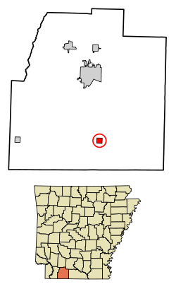
Columbia County Arkansas Incorporated and Unincorporated areas Emerson Highlighted 0521580.svg
Location of Emerson in Columbia County, Arkansas.
Coordinates: 33°05′50″N93°11′46″W / 33.09722°N 93.19611°W / 33.09722; -93.19611
Country United States
State Arkansas
County Columbia
Area
[1]
  Total0.99 sq mi (2.57 km2)
  Land0.99 sq mi (2.57 km2)
  Water0.00 sq mi (0.00 km2)
Elevation
[2]
308 ft (94 m)
Population
 (2020)
  Total293
  Density295.66/sq mi (114.17/km2)
Time zone UTC-6 (Central (CST))
  Summer (DST) UTC-5 (CDT)
ZIP code
71740
Area code 870
FIPS code 05-21580
GNIS feature ID2406449 [2]
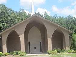
Brister Baptist Church on U.S. Highway 79 north of Emerson. Brister Baptist Church in Emerson, AR IMG 2205.JPG
Brister Baptist Church on U.S. Highway 79 north of Emerson.

Emerson is a town in Columbia County, Arkansas, United States. The population was 368 at the 2010 census. [3]

Contents

History

Eponym

Emerson derives its name from Reuben Logan Emerson, an early settler of Columbia County, who was a teacher, merchant, banker, owner of the newspaper The Columbia Banner, and state representative. In 1905, he founded the town which today bears his name. Emerson celebrated its 100th birthday February 8, 2005.

Geography

Emerson is located in southern Columbia County and is located along U.S. Route 79, 12 miles (19 km) south of Magnolia, the county seat, and 9 miles (14 km) north of Haynesville, Louisiana.

Emerson is also 68 miles (109 km) from Shreveport, Louisiana, and 205 miles (330 km) from Dallas, Texas.

According to the United States Census Bureau, Emerson has a total area of 1.0 square mile (2.6 km2), all land. [3]

Demographics

Historical population
CensusPop.Note
1920 357
1930 3734.5%
1940 50134.3%
1950 5234.4%
1960 350−33.1%
1970 39312.3%
1980 44413.0%
1990 317−28.6%
2000 35913.2%
2010 3682.5%
2020 293−20.4%
U.S. Decennial Census [4]
2014 Estimate [5]

As of the census [6] of 2010, there were 368 people, 138 households, and 97 families residing in the town. The population density was 140.0 people/km2 (363 people/sq mi). There were 165 housing units at an average density of 64.4 units/km2 (167 units/sq mi). The racial makeup of the town was 66% White, 32.60% Black or African American, and 0.3% from other races. 1.1% of the population were Hispanic or Latino of any race.

There were 138 households, out of which 35.5% had children under the age of 18 living with them, 50.7% were married couples living together, 15.2% had a female householder with no husband present, and 29.7% were non-families. 26.8% of all households were made up of individuals, and 13.8% had someone living alone who was 65 years of age or older. The average household size was 2.60 and the average family size was 3.16.

In the town, the population was spread out, with 28.7% under the age of 18, 7.5% from 18 to 24, 28.4% from 25 to 44, 17.3% from 45 to 64, and 18.1% who were 65 years of age or older. The median age was 36 years. For every 100 females, there were 92.0 males. For every 100 females age 18 and over, there were 88.2 males.

The median income for a household in the town was $32,969, and the median income for a family was $40,000. Males had a median income of $32,333 versus $17,500 for females. The per capita income for the town was $14,988. About 17.7% of families and 27.2% of the population were below the poverty line, including 46.9% of those under age 18 and 16.3% of those age 65 or over.

Economy

Major industries in the area are timber, bromine and bromine-based products, and oil.[ citation needed ]

Infrastructure

Highways

Arts and culture

Annual cultural events

Each year since 1990, on the last Saturday of June, Emerson hosts the Purple Hull Peas Festival & World Championship Rotary Tiller Race.

Education

Public education for early childhood, elementary and secondary school students is primarily provided by the Emerson-Taylor-Bradley School District (formerly the Emerson-Taylor School District), which includes Emerson Elementary School and Emerson High School. The district was established on July 1, 2004, by the consolidation of the Emerson School District and the Taylor School District. [7] The Emerson Pirates have won five state basketball championships and 25 state track and field titles.

Related Research Articles

<span class="mw-page-title-main">Lafayette County, Arkansas</span> County in Arkansas, United States

Lafayette County is a county located in the U.S. state of Arkansas. As of the 2020 census, the population was 6,308, making it the third-least populous county in Arkansas. The county seat is Lewisville. Lafayette County was formed on October 15, 1827, and named in honor of the Marquis de Lafayette, a French military hero of the American Revolutionary War. It is a dry county; therefore, the sale of alcohol is prohibited.

<span class="mw-page-title-main">Columbia County, Arkansas</span> County in Arkansas, United States

Columbia County is a county located in the U.S. state of Arkansas. As of the 2020 census, the population was 22,801. The county seat is Magnolia. The county was formed on December 17, 1852, and was named for Christopher Columbus. The Magnolia, AR Micropolitan Statistical Area includes all of Columbia County.

<span class="mw-page-title-main">Garfield, Arkansas</span> Town in Arkansas, United States

Garfield is a town in Benton County, Arkansas, United States. The population was 593 at the 2020 census. It is part of the Northwest Arkansas region.

<span class="mw-page-title-main">Gateway, Arkansas</span> Town in Arkansas, United States

Gateway is a town in Benton County, Arkansas, United States. The population was 436 at the 2020 census, up from 405 in 2010. It is part of the Northwest Arkansas region. The town's name reflects its situation as the "gateway" to and from Arkansas.

<span class="mw-page-title-main">Pea Ridge, Arkansas</span> City in Arkansas

Pea Ridge is a city in Benton County, Arkansas, United States. The name Pea Ridge is derived from a combination of the physical location of the original settlement of the town, across the crest of a ridge of the Ozark Mountains, and for the hog peanuts or turkey peas that had been originally cultivated by Native American tribes centuries before European settlement, which later helped to provide basic subsistence once those pioneer settlers arrived.

<span class="mw-page-title-main">Hampton, Arkansas</span> Town in Arkansas, United States

Hampton is a town in Calhoun County, Arkansas, United States. The population was 1,181 according to the 2020 United States Census. The town is the county seat of Calhoun County.

<span class="mw-page-title-main">Whelen Springs, Arkansas</span> Town in Arkansas, United States

Whelen Springs is a town in Clark County, Arkansas, United States. The population was 92 at the 2010 census. From 1930 through 1939 the town thrived, being a main hub of operations for the then powerful Ozan Lumber Company.

<span class="mw-page-title-main">McNeil, Arkansas</span> City in Arkansas, United States

McNeil is a town in Columbia County, Arkansas, United States. The population was 516 at the 2010 census, down from 662 in 2000. The community was named after William B. McNeil, founder of the College Hill Academy.

<span class="mw-page-title-main">Taylor, Arkansas</span> City in Arkansas, United States

Taylor is a city in Columbia County, Arkansas, United States. The population was 566 at the 2010 census.

<span class="mw-page-title-main">Anthonyville, Arkansas</span> Town in Arkansas, United States

Anthonyville is a town in Crittenden County, Arkansas, United States. The population was 161 at the 2010 census, down from 250 in 2000.

<span class="mw-page-title-main">Crawfordsville, Arkansas</span> Town in Arkansas, United States

Crawfordsville, historically Crawfordville, is a town in Crittenden County, Arkansas, United States. The population was 479 at the 2010 census.

<span class="mw-page-title-main">Edmondson, Arkansas</span> Town in Arkansas, United States

Edmondson is a town in Crittenden County, Arkansas, United States. The population was 427 at the 2010 census.

<span class="mw-page-title-main">Lonsdale, Arkansas</span> Town in Arkansas, United States

Lonsdale is a town in Garland County, Arkansas, United States. It is part of the Hot Springs Metropolitan Statistical Area. The population was 103 at the 2020 census.

<span class="mw-page-title-main">Patmos, Arkansas</span> Town in Arkansas, United States

Patmos is a town in Hempstead County, Arkansas, United States. The population was 64 at the 2010 census. It bears the same name as the Greek island of Patmos.

<span class="mw-page-title-main">Bradley, Arkansas</span> City in Arkansas, United States

Bradley is a city in Lafayette County, Arkansas, United States. The population was 628 at the 2010 census.

<span class="mw-page-title-main">Morrison Bluff, Arkansas</span> Town in Arkansas, United States

Morrison Bluff is a town in Logan County, Arkansas, United States. The population was 64 at the 2010 census and an estimated 81 in 2017.

<span class="mw-page-title-main">Dell, Arkansas</span> Town in Arkansas, United States

Dell is a town in Mississippi County, Arkansas, United States. The population was 194 at the 2020 census.

<span class="mw-page-title-main">Oden, Arkansas</span> Town in Arkansas, United States

Oden is a town in Montgomery County, Arkansas, United States. As of the 2020 census, its population was 180, down from 232 in 2010.

<span class="mw-page-title-main">Colt, Arkansas</span> Town in Arkansas, United States

Colt is a town and an unincorporated area in St. Francis County, Arkansas, United States. The population was 378 at the 2010 census, an increase from 368 in 2000.

<span class="mw-page-title-main">Orangeville, Pennsylvania</span> Borough in Pennsylvania, United States

Orangeville is a borough in Columbia County, Pennsylvania, United States. It is part of Northeastern Pennsylvania. The population was 478 at the 2020 census. It is part of the Bloomsburg-Berwick micropolitan area.

References

  1. "2020 U.S. Gazetteer Files". United States Census Bureau. Retrieved October 29, 2021.
  2. 1 2 U.S. Geological Survey Geographic Names Information System: Emerson, Arkansas
  3. 1 2 "Geographic Identifiers: 2010 Demographic Profile Data (G001): Emerson town, Arkansas". U.S. Census Bureau, American Factfinder. Archived from the original on February 12, 2020. Retrieved June 18, 2014.
  4. "Census of Population and Housing". Census.gov. Retrieved June 4, 2015.
  5. "Annual Estimates of the Resident Population for Incorporated Places: April 1, 2010 to July 1, 2014". Archived from the original on May 22, 2015. Retrieved June 4, 2015.
  6. "U.S. Census website". United States Census Bureau . Retrieved January 31, 2008.
  7. "ConsolidationAnnex_from_1983.xls Archived 2015-09-12 at the Wayback Machine ." Arkansas Department of Education. Retrieved on October 13, 2017.