Erpeldange-sur-Sûre

Last updated • 1 min readFrom Wikipedia, The Free Encyclopedia
Erpeldange-sur-Sûre
Ierpeldeng op der Sauer (Luxembourgish)
Erpeldingen an der Sauer (German)
Erpeldange Panorama.jpg
Coat of arms erpeldange luxbrg.png
Erpeldange Sure map.svg
Map of Luxembourg with Erpeldange highlighted in orange, and the canton in dark red
Coordinates: 49°51′50″N6°06′50″E / 49.8639°N 6.1139°E / 49.8639; 6.1139
Country Flag of Luxembourg.svg  Luxembourg
Canton Diekirch
Government
  Mayor Claude Gleis
Area
  Total
17.97 km2 (6.94 sq mi)
  Rank 64th of 100
Highest elevation
459 m (1,506 ft)
  Rank 24th of 100
Lowest elevation
190 m (620 ft)
  Rank 21st of 100
Population
 (2023)
  Total
2,429
  Rank 63rd of 100
  Density140/km2 (350/sq mi)
   Rank 56th of 100
Time zone UTC+1 (CET)
  Summer (DST) UTC+2 (CEST)
LAU 2 LU0000604
Website erpeldange.lu

Erpeldange-sur-Sûre (Luxembourgish : Ierpeldeng op der Sauer [ˈiːɐ̯pəldeŋopˈzɑʊɐ] , German : Erpeldingen an der Sauer [ˈɛʁpl̩dɪŋənʔandeːɐ̯ˈzaʊɐ] ) is a commune and small town in north-eastern Luxembourg. It lies along the river Sûre, between Ettelbruck and Diekirch. It is part of the canton of Diekirch.

Contents

As of 2024, the town of Erpeldange, which lies in the centre of the commune, has a population of 1,138. [1] Other towns within the commune include Burden and Ingeldorf.

Erpeldange-sur-Sûre was formed on 1 July 1850, when it was detached from the commune of Ettelbruck, along with the commune of Schieren. The law forming Erpeldange-sur-Sûre was passed on the 22 January 1850. [2]

Erpeldange Castle now houses the commune's administrative offices. It has a history dating from the 13th century. [3]

Demographics

Between 2011 and 2021, Erpeldange-sur-Sûre was the slowest growing commune in Luxembourg.

Historical population
YearPop.±%
1821604    
1851856+41.7%
1871754−11.9%
1880649−13.9%
1890562−13.4%
1900676+20.3%
1910676+0.0%
1922668−1.2%
1930658−1.5%
YearPop.±%
1947593−9.9%
1960646+8.9%
1970864+33.7%
19811,160+34.3%
19911,548+33.4%
20012,061+33.1%
20112,295+11.4%
20212,435+6.1%
Source: Le Portail des Statistiques du Luxembourg
Sure River at Erpeldange-sur-Sure Sure bij Erpeldange.jpg
Sûre River at Erpeldange-sur-Sûre
Erpeldange, church (l'eglise de la Conversion-de-Saint-Paul) in the street Erpeldange, kerk in straatzicht foto1 2014-06-09 14.38.jpg
Erpeldange, church (l'église de la Conversion-de-Saint-Paul) in the street

Related Research Articles

<span class="mw-page-title-main">Diekirch District</span>

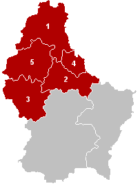
The District of Diekirch was one of three districts of the Grand Duchy of Luxembourg. Immediately prior to its abolition on 3 October 2015, it contained five cantons divided into 43 communes:

  1. Clervaux
  2. Diekirch
  3. Redange
  4. Vianden
  5. Wiltz
<span class="mw-page-title-main">Reisdorf</span> Commune in Diekirch, Luxembourg

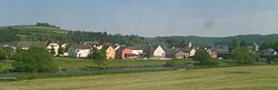
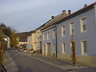
Reisdorf is a commune and small town in eastern Luxembourg, on the river Sauer. It is part of the canton of Diekirch.

<span class="mw-page-title-main">Sauer</span> River in Belgium, Luxembourg and Germany

The Sauer or Sûre is a river in Belgium, Luxembourg and Germany. A left tributary of the Moselle, its total length is 173 kilometres (107 mi).

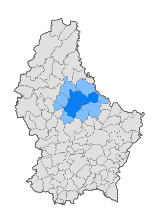
The 12 cantons of the Grand Duchy of Luxembourg are subdivisions at the first level of local administrative unit (LAU-1) in the European Union's Nomenclature of Territorial Units for Statistics for Eurostat purposes. They were subdivisions of the three districts of Luxembourg until 2015, when the district level of government was abolished. The cantons are in turn subdivided into 100 communes.

<span class="mw-page-title-main">Bettendorf, Luxembourg</span> Commune in Diekirch, Luxembourg

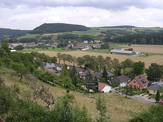
Bettendorf is a commune and town in eastern Luxembourg. It lies along the river Sauer. It is part of the canton of Diekirch, which is part of the district of Diekirch.

<span class="mw-page-title-main">Canton of Diekirch</span> Canton in Nord, Luxembourg

Diekirch is a canton in the north of Luxembourg. Neither the canton, town, nor commune of Diekirch should be confused with the former district of Diekirch, one of three administrative units in Luxembourg abolished in October 2015. It borders Germany.

<span class="mw-page-title-main">Diekirch</span> Commune in Luxembourg

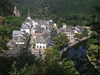
Diekirch is a commune with town status in north-eastern Luxembourg, in the canton of Diekirch and, until its abolition in 2015, the district of Diekirch. The town is situated on the banks of the Sauer river.

<span class="mw-page-title-main">Hamm, Luxembourg</span> Quarter in Luxembourg City, Luxembourg

Hamm is a quarter in eastern Luxembourg City, in southern Luxembourg. It is the home of the Luxembourg American Cemetery and Memorial, the final resting place of 5,076 American servicemen, including General Patton.

<span class="mw-page-title-main">Ettelbruck</span> Commune in Diekirch, Luxembourg

Ettelbruck is a commune with town status in central Luxembourg, with a population of 9,965 inhabitants.

<span class="mw-page-title-main">Canton of Redange</span> Canton in Nord, Luxembourg

Redange is a canton in the northwest of Luxembourg. Its namesake commune is Redange, officially known as Redange-sur-Attert. It borders the cantons of Wiltz to the north, Diekirch and Mersch to the east, Capellen to the south and Belgium to the west.

<span class="mw-page-title-main">Communes of Luxembourg</span> Aspect of Luxembourgish geography

Luxembourg's 100 communes conform to LAU Level 2 and are the country's lowest administrative divisions.

<span class="mw-page-title-main">Schieren</span> Commune in Diekirch, Luxembourg

Schieren is a commune and town in central Luxembourg. It is part of the canton of Diekirch.

<span class="mw-page-title-main">Esch-sur-Sûre</span> Commune in Wiltz, Luxembourg

Esch-sur-Sûre is a commune and small town in north-western Luxembourg. It is part of the canton of Wiltz, which is part of the district of Diekirch. At one point it was the second smallest commune by area in Luxembourg, until Neunhausen and Heiderscheid were merged into it in 2011.

<span class="mw-page-title-main">Heiderscheid</span> Town in Luxembourg

Heiderscheid is a small town in northwestern Luxembourg. It is part of the canton of Wiltz, which is part of the district of Diekirch.

<span class="mw-page-title-main">Pétange</span> Commune in Esch-sur-Alzette, Luxembourg

Pétange is a commune and town in south-western Luxembourg. It is part of the canton of Esch-sur-Alzette and is the fifth-most populous commune in Luxembourg, as well as the most populous without town status. Pétange lies at the borders with both Belgium and France.

<span class="mw-page-title-main">Société Nationale des Chemins de Fer Luxembourgeois</span> State-owned railway company of Luxembourg

The Société Nationale des Chemins de Fer Luxembourgeois is the national railway company of Luxembourg. In 2023, it carried approximately 28.7 million passengers. As of 2023, the company employs around 5,000 people, making CFL the country's largest corporate employer.

<span class="mw-page-title-main">Nordstad</span>

Nordstad is a development area in north-central Luxembourg, and a colloquial term to refer to the combined urban areas in the region. The name is Luxembourgish for 'northern city', but it remains the title, both formal and informal, of the region in any language.

<span class="mw-page-title-main">Born, Luxembourg</span>

Born is a village on the River Sauer in the commune of Mompach, in eastern Luxembourg. It lies on the N10, 14 km (9 mi) south of Echternach and 8 km (5 mi) north of Wasserbillig. Only a 5 minute drive from the E44 motorway from Luxembourg City to Trier, it is popular with tourists and day-trippers who walk, cycle or fish along the banks of the river.

<span class="mw-page-title-main">History of rail transport in Luxembourg</span>

The history of rail transport in Luxembourg began in 1846 and continues to the present day.

References

  1. "Registre national des personnes physiques RNPP : Population par localité". data.public.lu. 2024-01-07.
  2. "Mémorial A, 1850, No. 18" (PDF) (in French). Service central de législation. Archived from the original (PDF) on 2007-03-15. Retrieved 2006-08-15.
  3. "Histoire" Archived 2009-12-01 at the Wayback Machine , Commune d'Erpeldange. (in French) Retrieved 26 March 2011.

Commons-logo.svg Media related to Erpeldange (Ettelbruck) at Wikimedia Commons