
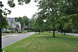
The West Newton Hill NR Historic District is a residential National Register historic district in the village of West Newton, in the city of Newton, Massachusetts in the United States. It is composed of a cohesive collection of spacious houses built in the second half of the 19th century, representing the development of the West Newton area as a fashionable railroad suburb. The district was listed on the National Register of Historic Places in 1986.
The Washington Park Historic District is a historic district in the village of Newtonville, in Newton, Massachusetts. It includes the following properties, dating to between 1870 and 1900: 4 to 97 Washington Park plus 5 and 15 Park Place. The focal point of the district is the city park which is located in the median of the street of the same name. On March 12, 2008, it was added to the National Register of Historic Places.

The Everett Avenue–Sheffield Road Historic District is a historic district encompassing one of the finest residential districts from the turn of the 20th century in Winchester, Massachusetts. The district is roughly triangular in shape, bounded in the north by Bacon Street, on the west by Church Street, Sheffield West, and Sheffield Road, and on the south and heast by the Upper Mystic Lake and Mystic Valley Parkway. It is characterized by winding roads, with relatively large houses on well-proportioned lots. Most of the houses were built between 1890 and 1916, and all exhibit some architectural sophistication. A significant number of properties were designed by either F. Patterson Smith or Dexter Blaikie, two local architects. The district was listed on the National Register of Historic Places in 1989.

The Woodford Street Historic District includes a cohesive collection of five triple decker houses at 35–39 and 38–40 Woodford Street in Worcester, Massachusetts. Built about 1926, they are a well-preserved group of Colonial Revival houses built in the last phase of the city's triple decker development. The district was listed on the National Register of Historic Places in 1990.

The Nobility Hill Historic District is a residential historic district roughly bounded by Chestnut and Maple Streets and Cedar Avenue in Stoneham, Massachusetts. The district includes a number of high quality houses representing a cross section of fashionable housing built between 1860 and 1920. It was added to the National Register of Historic Places in 1990.

Hammond Heights is an historic neighborhood subdivision on the west side of Worcester, Massachusetts. It includes properties along Germain, Haviland, Highland, and Westland Streets and Institute Road, most of which were built between 1890 and 1918, and is a good example of a turn-of-the-century residential subdivision, with a diversity of period architectural styles. The district was listed on the National Register of Historic Places in 1980.

Wakefield Park Historic District is a residential historic district encompassing a portion of a late-19th/early-20th century planned development in western Wakefield, Massachusetts. The district encompasses sixteen properties on 8 acres (3.2 ha) of land out of the approximately 100 acres (40 ha) that comprised the original development. Most of the properties in the district are on Park Avenue, with a few located on immediately adjacent streets.

The Brae Burn Road Historic District is a residential historic district on Brae Burn and Windermere Roads in Newton, Massachusetts. It encompasses as modest residential subdivision that was laid out in the then-rural area of Auburndale in 1911. Many of its houses were designed by the regionally notable firm of Gay & Proctor, and represent a well-preserved collection of modestly scaled Craftsman and Colonial Revival style houses. The district includes 26 houses. The district was listed on the National Register of Historic Places in 1990.

The Commonwealth Avenue Historic District of Newton, Massachusetts, encompasses roughly the eastern half of Commonwealth Avenue, extending from Waban Hill Road, near the city line with Boston, westward to Walnut Street. The roadway was laid out in 1894 and completed in 1895. Its design was influenced in part by the local residents, who were willing to give land for some of the route, and the design of Boston portions of the road, in which Frederick Law Olmsted was involved. Construction of the roadway was followed by the construction of fashionably large residences along its route, which took place mostly between the road's construction and about 1920. The district includes 188 residential properties, which are mainly built in the revival styles popular in the early 20th century. The district was added to the National Register of Historic Places in 1990.

The Farlow and Kenrick Parks Historic District is a predominantly residential historic district in the Newton Corner area of Newton, Massachusetts. The district is roughly triangular in shape, and is bounded on the north by the Massachusetts Turnpike, Park Street to the east, and Franklin and Newtonville Avenues to the west. It is roughly bisected by Church Street, and is named for two parks that are significant focal elements of the district. Kenrick Park is a small lozenge-shaped park at the southern tip of the district designed by Alexander Wadsworth; it was laid out at the request of William Kenrick, a horticulturalist whose c. 1822 Federal style house was moved to the area after the park was completed. Farlow Park is a larger rectangular park, in the district's northwest, which was established by a gift from John Farlow. It is landscaped in a manner similar to the Boston Public Garden, with specimen trees and an artificial pond with bridge.

The Gray Cliff Historic District is a residential historic district encompassing a cluster of exceptionally high quality houses built in Newton, Massachusetts, between about 1890 and 1940. When first listed on the National Register of Historic Places in 1986, it included only the eight houses at 35, 39, 43, 53, 54, 64, 65, and 70 Gray Cliff Road, which were predominantly Shingle style house built before the turn of the 20th century. The district was expanded in 1990 to include an adjacent area known as The Ledges, where the houses were built between 1900 and 1940, and are mainly Colonial Revival and Tudor Revival in their styling.

The Hyde Avenue Historic District is a residential historic district encompassing the stylistic range of houses being built in the Newton Corner area of Newton, Massachusetts in the 1880s. It includes the five houses at 36, 42, 52, 59, and 62 Hyde Avenue, The district was added to the National Register of Historic Places in 1986.

The Monadnock Road Historic District is a residential historic district encompassing a cohesive subdivision of a former estate in the 1920s in the Chestnut Hill section of Newton, Massachusetts. The development was typical of Newton's explosive residential growth at that time, and includes primarily Tudor Revival houses. The district was listed on the National Register of Historic Places in 1990.
The Morton Road Historic District encompasses an example of a small residential subdivision in Newton, Massachusetts that was attractively designed in 1915. The architect-designed subdivision filled in an area otherwise surrounded by roads that had been developed earlier, and was built out between 1915 and 1928, with a fairly uniform use of Craftsman and Tudor Revival styling. The district was listed on the National Register of Historic Places in 1990.

The Old Chestnut Hill Historic District encompasses the historic residential heart of the Newton portion of Chestnut Hill, Massachusetts. When first listed on the National Register of Historic Places in 1986, the district extended along Hammond Street, between Beacon Street and the MBTA Green Line right-of-way, and along Chestnut Hill Road between Hammond and Essex, including properties along a few adjacent streets. The district was expanded in 1990 to include more of Chestnut Hill Road and Essex Road, Suffolk Road and the roads between it and Hammond, and a small section south of the Green Line including properties on Hammond Street, Longwood Road, and Middlesex Road. A further expansion in 1999 added a single property on Suffolk Road.

The Pine Ridge Road–Plainfield Street Historic District encompasses a residential subdivision in the Waban section of Newton, Massachusetts. It includes 44 properties on Pine Ridge Road and Plainfield Street between Chestnut Street and Upland Road, and includes a few properties on the latter two streets. The area was laid out for development in the 1880s after the arrival of suburban rail service, and was built out by the 1930s. The district was listed on the National Register of Historic Places in 1990.

The Windsor Road Historic District is a residential historic district just north of the village of Waban in Newton, Massachusetts.It includes 48 houses on Windsor, Kent and Hereford Roads, a cul-de-sac subdivision adjacent to the village center and the Brae Burn Country Club, which was mostly developed between 1888 and 1920. It was added to the National Register of Historic Places in 1990.

The Sumner and Gibbs Streets Historic District is a residential historic district encompassing a cohesive collection of houses representing styles common in the Newton Centre area of Newton, Massachusetts during its first period of growth. It includes houses along Sumner Street, between Cotswold Terrace and Willow Street, and the adjacent house at 184 Gibbs Street. The houses were built between 1865 and 1899, and are predominantly in the Queen Anne and Colonial Revival styles. The district was listed on the National Register of Historic Places in 1986.

The Chestnut Hill Historic District encompasses the historic portion of the village of Chestnut Hill that lies in Brookline, Massachusetts, with only slight overlap into adjacent Newton. The 70-acre (28 ha) district is bounded on the north by Middlesex Road, on the east by Reservoir Lane, on the south by Crafts Road and Massachusetts Route 9, and on the west by Dunster Road. A small portion of the district extends south of Route 9, including a few houses and the Baldwin School on Heath Street. The district was listed on the National Register of Historic Places on October 17, 1985.

The Intervale Street-Columbia Road Historic District is a historic district encompassing a small residential area in the Dorchester neighborhood of Boston, Massachusetts. Centered on a stretch of Intervale Street, the area was developed in the early 20th century during a major Jewish migration, and includes a fine sample of Colonial Revival architecture. The district was listed on the National Register of Historic Places in 2019.


