Ballardvale is a village located within the boundaries of the town of Andover, Essex County, Massachusetts, United States. Growing originally in the 19th century around mills located on the Shawsheen River, the village is a local historic district, boasting many varieties of historic architecture and a rich industrial heritage.

Slatersville is a village on the Branch River in the town of North Smithfield, Rhode Island, United States. It includes the Slatersville Historic District, a historic district listed on the National Register of Historic Places. The historic district has been included as part of the Blackstone River Valley National Historical Park. The North Smithfield Public Library is located in Slatersville.
Waterford is a village located on and around St. Paul Street in North Smithfield, Rhode Island and Blackstone, Massachusetts. The Blackstone River and Branch River converge just south of the village.

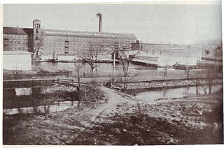
The Blackstone Manufacturing Company Historic District encompasses the "New City" or "High Rocks" area of Blackstone, Massachusetts, an industrial village associated with the Blackstone Manufacturing Company, which began operations in 1809. It includes an area roughly surrounding Butler, Canal, Church, County, Ives, Main, Mendon, Old Mendon, and School Streets. The district includes a wide variety of worker housing, as well as a granite storehouse, the only surviving company structure. The district was added to the National Register of Historic Places in 1995.

The East Blackstone Village Historic District is a historic district roughly along Elm Street at the junction with Summer Street in eastern Blackstone, Massachusetts. It encompasses a small 19th-century mill village center that developed along what was once a major roadway connecting Worcester with Providence, Rhode Island. The district was added to the National Register of Historic Places in 1995.

The Center Village District encompasses the historic village center of Lancaster, Massachusetts. Settled in 1643, it has few traces of its early history, but is now a well-kept rural town center with a predominantly residential and civic character. It includes the First Church of Christ, Lancaster, which is a U.S. National Historic Landmark, and was listed on the National Register of Historic Places in 1977.

The Lower Highlands Historic District encompasses one of the oldest residential areas of Fall River, Massachusetts. The district is roughly bounded by Cherry, Main, Winter, and Bank Streets, and is located just east of the Downtown Fall River Historic District and directly south of the Highlands Historic District. This area was settled by 1810, has architecture tracing the city's growth as a major industrial center. The historic district was added to the National Register of Historic Places in 1984.

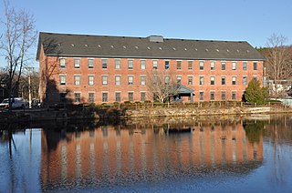
Farnumsville Historic District is a historic district encompassing a historic mill village in Grafton, Massachusetts. It is located on the eastern bank of the Blackstone River, extending along Providence and Main Streets, roughly between Cross and Depot Streets, and radiating along those roads and adjacent streets. This area was one of Grafton's 19th century industrial mill villages, which was centered on the Farnum Mill, which first began operating in the second decade of the 19th century. The main mill building that survives dates to 1844, and the housing stock in the village is in a diversity of styles, built roughly between the 1820s and 1920s.
The Baldwinville Village Historic District encompasses the historic elements of the village of Baldwinville, a 19th-century mill village in northern Templeton, Massachusetts. Although its industrial elements have largely been lost, the district retains period housing and civic buildings. It was listed on the National Register of Historic Places in 1986.

The Cushman Village Historic District is a historic district encompassing a portion of the Cushman Village area of Amherst, Massachusetts, which was a significant mill village during the 19th century. It is centered on the triangle formed by Bridge, Henry, and Pine Streets in northeastern Amherst, and arose because of the presence of falls on the Mill River, whose water power was harnessed for mills as early as the mid-18th century. Two houses survive from the colonial period. The village, although it was defined for many years by the mills, no longer has any industrial buildings, as they were demolished or destroyed by fire. Most of the houses in the district were built before 1860, the peak of the village's industrial activity. The district was listed on the National Register of Historic Places in 1992.

The Williamsburg Center Historic District is a historic district on Massachusetts Route 9 in Williamsburg, Massachusetts. It encompasses the traditional center of the town, which was settled in the 18th century and grew to prosperity in the mid-19th century. It was listed on the National Register of Historic Places in 1980.

The Dwight Manufacturing Company Housing District is a residential historic district in Chicopee, Massachusetts. Roughly bounded by Front, Depot, Dwight, Exchange, and Chestnut Streets, it encompasses a variety of housing built for mill workers at Chicopee's mills during the 19th century. This cluster is one of few remnants of such housing, which was built on a larger scale now diminished by urban renewal. The district was listed on the National Register of Historic Places in 1977.

The Centre Village Historic District encompasses the historic central business district of Southbridge, Massachusetts. The district includes properties on Main Street, roughly between Elm and Goddard Streets. The central area represents a fairly well preserved Late Victorian commercial center. It was added to the National Register of Historic Places in 1979.
The history of Uxbridge, Massachusetts, founded in 1727, may be divided into its prehistory, its colonial history and its modern industrial history. Uxbridge is located on the Massachusetts-Rhode Island state line, and became a center of the earliest industrialized region in the United States.

The East Jaffrey Historic District is a historic district running roughly along NH Route 124 through Jaffrey, New Hampshire. It encompasses what is now the economic and civic heart of the town, centered on the Jaffrey Mills and the crossing of the Contoocook River by Route 124. It extends as far west as St. Patrick's Church beyond Charlonne Street and as far east as the US Post Office building at Route 124 and Ellison Street. To the north it extends along Peterborough Street to Christian Court, and to the south it extends along River Street and School Street to their junction. The district includes early 19th-century residential structures, as well as industrial buildings and housing associated with the Jaffrey Mills which arose in the mid-19th century. The district was added to the National Register of Historic Places in 2002.

The Head of the River Historic District is a historic district encompassing a village area at the head of navigation of the Acushnet River, which separates Acushnet and New Bedford, Massachusetts. The village is centered at the junction of Tarkiln Hill Road, River Road, and Mill Road in New Bedford, and Main Street in Acushnet. The area went through two significant periods of development: the first was in the late 18th and early 19th century, and the second was in the early 20th century. The district was listed on the National Register of Historic Places in 2009.
The William Rossiter House is a historic house at 11 Mulberry Street in Claremont, New Hampshire. Built in 1813 and enlarged by about 1850, it is a distinctive local example of Greek Revival architecture, with many surviving Federal period features. The house was listed on the National Register of Historic Places in 1979.

The Tilton Downtown Historic District encompasses a roughly one-block section of Main Street in the center of Tilton, New Hampshire. It extends from Central Street in the west to Bridge and School Streets in the east, including all of the buildings on the north side of this section, and a cluster of buildings on the south side near Bridge Street. The area has long been a commercial and industrial center for the town, although most of the buildings now date from the late 19th century onward, and include a fine array of Victorian architecture. The district was listed on the National Register of Historic Places in 1983.

The Mechanicsville Historic District encompasses a cluster of residential properties that are all that remain of one of the early industrial areas of Grafton, Vermont. Located a short way east of Grafton Village on Vermont Route 121, it includes ten well-preserved 19th-century properties, some located on properties where early mills once stood. The district was listed on the National Register of Historic Places in 2010.

The Plainfield Village Historic District encompasses a significant portion of the village of Plainfield, Vermont. Located in northernmost Plainfield on United States Route 2, the village grew in the 19th century as a mill town and service community for the surround agricultural areas, and has a well-preserved collection of Greek Revival and Italianate architecture. It was listed on the National Register of Historic Places in 1983.


