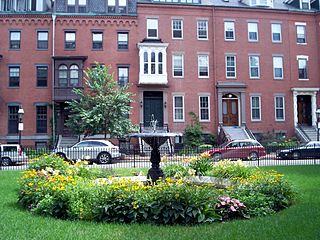
The South End is a neighborhood in Boston, Massachusetts, United States which is bordered by Back Bay, Chinatown, and Roxbury. It is distinguished from other neighborhoods by its Victorian-style houses and the parks in and around the area. The South End is the largest intact Victorian row-house district in the country, covering over 300 acres (120 ha). It has eleven residential parks. In 1973, the South End was listed on the National Register of Historic Places. Much of the neighborhood was originally marshlands in Boston's South Bay. After it was filled in, construction began in 1849.

Beacon Hill is a historic neighborhood in Boston, Massachusetts, United States, and the hill upon which the Massachusetts State House resides. The term "Beacon Hill" is used locally as a metonym to refer to the state government or the legislature itself, much like Washington, D.C.'s Capitol Hill does at the federal level.

Chestnut Hill is a wealthy New England village located six miles (10 km) west of downtown Boston, Massachusetts, United States. It is best known for being home to Boston College and a section of the Boston Marathon route. Like all Massachusetts villages, Chestnut Hill is not an incorporated municipal entity. It is located partially in Brookline in Norfolk County; partially in the city of Boston in Suffolk County, and partially in the city of Newton in Middlesex County. Chestnut Hill's borders are defined by the 02467 ZIP Code. The name refers to several small hills that overlook the 135-acre Chestnut Hill Reservoir rather than one particular hill.

The Tremont Street subway in Boston's MBTA subway system is the oldest subway tunnel in North America and the third-oldest still in use worldwide to exclusively use electric traction, opening on September 1, 1897. It was originally built, under the supervision of Howard A. Carson as chief engineer, to get streetcar lines off the traffic-clogged streets, instead of as a true rapid transit line. It now forms the central part of the Green Line, connecting Boylston Street to Park Street and Government Center stations.

Bay Village is the smallest officially recognized neighborhood of Boston, Massachusetts, United States. As of 2010, its population was approximately 1,312 residents living in 837 housing units, most of which are small brick rowhouses.

Mission Hill is a 3⁄4 square mile, primarily residential neighborhood of Boston, bordered by Roxbury, Jamaica Plain and Fenway-Kenmore and the town of Brookline. The neighborhood has two main streets, namely Tremont Street and Huntington Avenue. It is served by several stations on the MBTA's Green Line E branch, as well as Roxbury Crossing station on the Orange Line.

The Piano Row District is a historic district encompassing two blocks of buildings facing Boston Common at the corner of Tremont Street and Boylston Street in Boston, Massachusetts. The district extends along Boylston from Park Square to Tremont, and along Tremont to Avery Street. The district also includes two buildings on Tremont just south of Boylston: the Cutler Majestic Theater, and the 1925 Union Savings Bank building at 216-218 Tremont. This area was developed in the late 19th and early 20th centuries, and became known as "Piano Row" because of the concentration of music-related businesses, including several piano showrooms. The flagship store for M. Steinert and Sons, Boston's longtime Steinway dealer, has been located here since 1896, and features a fine underground performance hall, which has unfortunately been virtually abandoned due to fire codes.

The Lower Roxbury Historic District is a historic district encompassing an isolated pocket of 1890s mixed residential-commercial property in the lower Roxbury neighborhood of Boston, Massachusetts. Bounded by Tremont, Columbus, and Burke Streets and St. Cyprian's Place, the area contains a well-kept collection of architect designed buildings that survived late 20th-century urban redevelopment. The district was added to the National Register of Historic Places in 1994.
Monument Square Historic District is a predominantly residential historic district north of Monument Square in Jamaica Plain, a neighborhood of Boston, Massachusetts. The 43 acres (17 ha) district is bounded on the northwest by Pond Street, the northeast by Myrtle and Pond Streets, the southeast by Centre Street, and Holbrook and Eliot Streets to the west. This area, originally developed as country estates, was developed as a residential area in the late 19th and early 20th centuries, with its architecture reflecting a diversity of styles. Prominent non-residential buildings including the First Church of Jamaica Plain, Eliot Hall, and the Eliot School. Also included in the district is Jamaica Plain's Gothic Soldier's Monument, at the junction of South and Centre Streets.

Mount Pleasant Historic District is a historic district encompassing a cluster of well-preserved 19th-century residential buildings on Forest Street and Mount Pleasant Avenue in the Roxbury neighborhood of Boston, Massachusetts. First developed in 1833, it was one Roxbury's first speculative residential subdivision developments. The district features Greek Revival, Italianate, and Romanesque architecture, and was added to the National Register of Historic Places in 1989.
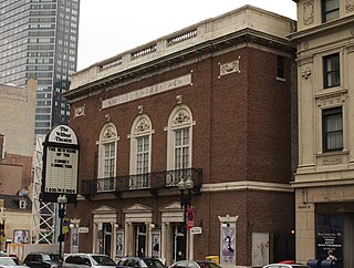
The Wilbur Theatre is a historic performing arts theater at 244–250 Tremont Street in Boston, Massachusetts. The Wilbur Theatre originally opened in 1914, but underwent renovations in 2008. The Wilbur Theatre sits in the heart of Boston's historic theater district and is known for hosting live comedy and music.

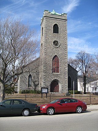
Beth Israel Synagogue is a historic former Jewish synagogue building at 238 Columbia Street in Cambridge, Middlesex County, Massachusetts, in the United States. Built in 1903, it was the first and principal synagogue to serve the East Cambridge area, and is a fine local example of Romanesque Revival architecture. Now converted into residential condominiums, it was listed on the National Register of Historic Places in 1982.

Case's Corner Historic District is a residential, civic, and rural historic district in the geographic center of Weston, Massachusetts. The district is centered on the four-way intersection of School, Wellesley, Newton and Ash Streets in Weston, Massachusetts, and runs mainly along Wellesley Street, which runs north-south through the district between the centers of Weston and Wellesley. The district encompasses a pastoral landscape managed by Marian Case, a horticulturalist and landscape preservationist. One of its central features is the Case Estates, a 60-acre (24 ha) property bequested by Case to Harvard University that once served as a nursery for Boston's Arnold Arboretum. The district was listed on the National Register of Historic Places in 2002.

The Commonwealth Avenue Historic District of Newton, Massachusetts, encompasses roughly the eastern half of Commonwealth Avenue, extending from Waban Hill Road, near the city line with Boston, westward to Walnut Street. The roadway was laid out in 1894 and completed in 1895. Its design was influenced in part by the local residents, who were willing to give land for some of the route, and the design of Boston portions of the road, in which Frederick Law Olmsted was involved. Construction of the roadway was followed by the construction of fashionably large residences along its route, which took place mostly between the road's construction and about 1920. The district includes 188 residential properties, which are mainly built in the revival styles popular in the early 20th century. The district was added to the National Register of Historic Places in 1990.

The Monadnock Road Historic District is a residential historic district encompassing a cohesive subdivision of a former estate in the 1920s in the Chestnut Hill section of Newton, Massachusetts. The development was typical of Newton's explosive residential growth at that time, and includes primarily Tudor Revival houses. The district was listed on the National Register of Historic Places in 1990.

The Old Chestnut Hill Historic District encompasses the historic residential heart of the Newton portion of Chestnut Hill, Massachusetts. When first listed on the National Register of Historic Places in 1986, the district extended along Hammond Street, between Beacon Street and the MBTA Green Line right-of-way, and along Chestnut Hill Road between Hammond and Essex, including properties along a few adjacent streets. The district was expanded in 1990 to include more of Chestnut Hill Road and Essex Road, Suffolk Road and the roads between it and Hammond, and a small section south of the Green Line including properties on Hammond Street, Longwood Road, and Middlesex Road. A further expansion in 1999 added a single property on Suffolk Road.
The Beacon Street Historic District is a historic district running most of the length of Beacon Street in Brookline, Massachusetts, roughly from Saint Mary's Road, near Kenmore Square, to Ayr Road near Cleveland Circle. It includes a small number of properties on adjacent streets, and was listed on the National Register of Historic Places in 1985.

Fort Hill is a 0.4 square mile neighborhood and historic district of Roxbury, in Boston, Massachusetts. The approximate boundaries of Fort Hill are Malcolm X Boulevard on the north, Washington Street on the southeast, and Columbus Avenue on the southwest.

The Greenville Street Historic District is a historic district encompassing a primarily residential property in the Roxbury neighborhood of Boston, Massachusetts. Extending along Greenville Street, the district includes a diversity of architecture, and is prominent for significant urban renewal efforts conducted in the city in the 1960s and 1970s. The district was added to the National Register of Historic Places in 2021.