Fredonia, North Dakota

Last updated

Fredonia, North Dakota
Fredoniacentennial.jpg
ND Logan County Fredonia.svg
Location of Fredonia, North Dakota
Coordinates: 46°19′45″N99°05′44″W / 46.32917°N 99.09556°W / 46.32917; -99.09556
CountryUnited States
State North Dakota
County Logan
Founded1905
Area
[1]
  Total0.24 sq mi (0.62 km2)
  Land0.24 sq mi (0.62 km2)
  Water0.00 sq mi (0.00 km2)
Elevation
[2]
2,054 ft (626 m)
Population
 (2020)
  Total38
  Density158.33/sq mi (61.04/km2)
Time zone UTC-6 (CST)
  Summer (DST) UTC-5 (CDT)
ZIP code
58440
Area code 701
FIPS code 38-28380
GNIS feature ID1036045 [2]

Fredonia is a city in Logan County, North Dakota, United States. The population was 38 at the 2020 census. [3] Fredonia was founded in 1905.

Contents

Geography

According to the United States Census Bureau, the city has a total area of 0.24 square miles (0.62 km2), all land. [4]

Demographics

Historical population
CensusPop.Note
1920 296
1930 39433.1%
1940 309−21.6%
1950 268−13.3%
1960 141−47.4%
1970 100−29.1%
1980 82−18.0%
1990 66−19.5%
2000 51−22.7%
2010 46−9.8%
2020 38−17.4%
2021 (est.)38 [5] 0.0%
U.S. Decennial Census [6]
2020 Census [3]

2010 census

As of the census of 2010, there were 46 people, 23 households, and 16 families residing in the city. The population density was 191.7 inhabitants per square mile (74.0/km2). There were 37 housing units at an average density of 154.2 per square mile (59.5/km2). The racial makeup of the city was 100.0% White.

There were 23 households, of which 21.7% had children under the age of 18 living with them, 60.9% were married couples living together, 4.3% had a female householder with no husband present, 4.3% had a male householder with no wife present, and 30.4% were non-families. 30.4% of all households were made up of individuals, and 13% had someone living alone who was 65 years of age or older. The average household size was 2.00 and the average family size was 2.25.

The median age in the city was 49.7 years. 17.4% of residents were under the age of 18; 2.1% were between the ages of 18 and 24; 19.5% were from 25 to 44; 45.6% were from 45 to 64; and 15.2% were 65 years of age or older. The gender makeup of the city was 56.5% male and 43.5% female.

2000 census

As of the census of 2000, there were 51 people, 22 households and 13 families residing in the city. The population density was 212.9 inhabitants per square mile (82.2/km2). There were 30 housing units at an average density of 125.2 per square mile (48.3/km2). The racial makeup of the city was 96.08% White. Hispanic or Latino of any race were 3.92% of the population.

There were 22 households, of which 27.3% had children under the age of 18 living with them, 59.1% were married couples living together, and 40.9% were non-families. 36.4% of all households were made up of individuals, and 18.2% had someone living alone who was 65 years of age or older. The average household size was 2.32 and the average family size was 3.08.

23.5% of the population were under the age of 18, 2.0% from 18 to 24, 31.4% from 25 to 44, 27.5% from 45 to 64, and 15.7% who were 65 years of age or older. The median age was 40 years. For every 100 females, there were 88.9 males. For every 100 females age 18 and over, there were 95.0 males.

The median household income was $25,313 and the median family income was $36,250. Males had a median income of $21,563 versus $6,875 for females. The per capita income for the city was $15,837. There were 12.5% of families and 23.7% of the population living below the poverty line, including 42.9% of under eighteens and 33.3% of those over 64.

Related Research Articles

<span class="mw-page-title-main">Willey, Iowa</span> City in Iowa, United States

Willey is a city in Carroll County, Iowa, United States. The population was 73 at the time of the 2020 census.

<span class="mw-page-title-main">Hayesville, Iowa</span> City in Iowa, United States

Hayesville is a city in Keokuk County, Iowa, United States. The population was 41 at the time of the 2020 census.

<span class="mw-page-title-main">Fredonia, Iowa</span> City in Iowa, United States

Fredonia is a city in Louisa County, Iowa, United States. The population was 222 at the time of the 2020 census. It is part of the Muscatine Micropolitan Statistical Area.

<span class="mw-page-title-main">Garnett, Kansas</span> City in Anderson County, Kansas

Garnett is a city in and the county seat of Anderson County, Kansas, United States. As of the 2020 census, the population of the city was 3,242.

<span class="mw-page-title-main">Benedict, Kansas</span> City in Wilson County, Kansas

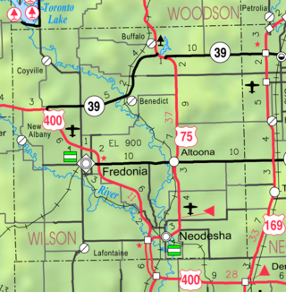
Benedict is a city in Wilson County, Kansas, United States, along the Verdigris River. As of the 2020 census, the population of the city was 69.

<span class="mw-page-title-main">Fredonia, Kansas</span> City in Wilson County, Kansas

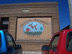
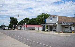
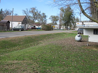
Fredonia is a city in and the county seat of Wilson County, Kansas, United States. As of the 2020 census, the population of the city was 2,151. The city was founded in 1868, and saw considerable expansion in the early 20th century, with a fossil fuel boom.

<span class="mw-page-title-main">Fredonia, Kentucky</span> City in Kentucky, United States

Fredonia is a home rule-class city in Caldwell County, Kentucky, in the United States. The population was 401 at the 2010 census.

<span class="mw-page-title-main">Erhard, Minnesota</span> City in Minnesota, United States

Erhard is a city in Otter Tail County, Minnesota, United States. The population was 132 at the 2020 census.

<span class="mw-page-title-main">Urbank, Minnesota</span> City in Minnesota, United States

Urbank is a city in Otter Tail County, Minnesota, United States. The population was 52 at the 2020 census.

<span class="mw-page-title-main">Lake Henry, Minnesota</span> City in Minnesota, United States

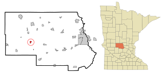
Lake Henry is a city in Stearns County, Minnesota, United States. The population was 103 at the 2010 census. It is part of the St. Cloud Metropolitan Statistical Area.

<span class="mw-page-title-main">St. Rosa, Minnesota</span> City in Minnesota, United States

Saint Rosa is a city in Stearns County, Minnesota, United States. The population was 68 at the 2010 census. It is part of the St. Cloud Metropolitan Statistical Area.

<span class="mw-page-title-main">Spring Hill, Minnesota</span> City in Minnesota, United States

Spring Hill is a city in Stearns County, Minnesota, United States. The population was 85 at the 2010 census. It is part of the St. Cloud Metropolitan Statistical Area.

<span class="mw-page-title-main">Clarkson Valley, Missouri</span> City in Missouri, United States

Clarkson Valley is a city in St. Louis County, Missouri, United States. The population was 2,609 at the 2020 census.

<span class="mw-page-title-main">Pomfret, New York</span> Town in New York, United States

Pomfret is a town in Chautauqua County, New York, United States. The population was 13.236 at the 2020 census. The town lies in the north-central part of the county, south of Dunkirk, and includes the village of Fredonia.

<span class="mw-page-title-main">Esmond, North Dakota</span> City in North Dakota, United States

Esmond is a city in Benson County, North Dakota, United States. The population was 91 at the 2020 census. Esmond was founded in 1901.

<span class="mw-page-title-main">Kramer, North Dakota</span> City in North Dakota, United States

Kramer is a city in Bottineau County, North Dakota, United States. The population was 24 at the 2020 census. Kramer was founded in 1905.

<span class="mw-page-title-main">Ayr, North Dakota</span> City in North Dakota, United States

Ayr is a city in Cass County, North Dakota, United States. The population was 11 at the 2020 census. Ayr was founded in 1883.

<span class="mw-page-title-main">Harrisburg, Oregon</span> City in Oregon, United States

Harrisburg is a city in Linn County, Oregon, United States. The population was 3,567 at the 2010 census.

<span class="mw-page-title-main">Coolspring Township, Mercer County, Pennsylvania</span> Township in Pennsylvania, United States

Coolspring Township is a township in Mercer County, Pennsylvania, United States. The population was 2,112 at the 2020 census, a decline from the figure of 2,278 in 2010.

<span class="mw-page-title-main">Bancroft, West Virginia</span> Town in West Virginia, United States

Bancroft is a town in Putnam County, West Virginia, United States, along the Kanawha River. The population was 389 at the 2020 census. It is part of the Huntington–Ashland metropolitan area.

References

  1. "ArcGIS REST Services Directory". United States Census Bureau. Retrieved September 20, 2022.
  2. 1 2 U.S. Geological Survey Geographic Names Information System: Fredonia, North Dakota
  3. 1 2 "Explore Census Data". United States Census Bureau . Retrieved July 14, 2022.
  4. "US Gazetteer files 2010". United States Census Bureau. Archived from the original on July 2, 2012. Retrieved June 14, 2012.
  5. "City and Town Population Totals: 2020-2021". United States Census Bureau. July 14, 2022. Retrieved July 14, 2022.
  6. United States Census Bureau. "Census of Population and Housing" . Retrieved January 23, 2014.