Fruitville, Florida

Last updated • 4 min readFrom Wikipedia, The Free Encyclopedia

Fruitville, Florida
Sarasota County Florida Incorporated and Unincorporated areas Fruitville Highlighted.svg
Location in Sarasota County and the state of Florida
Coordinates: 27°19′50″N82°27′42″W / 27.33056°N 82.46167°W / 27.33056; -82.46167 [1]
Country Flag of the United States.svg  United States
State Flag of Florida.svg  Florida
County   Sarasota
Area
[2]
  Total7.13 sq mi (18.46 km2)
  Land6.82 sq mi (17.68 km2)
  Water0.30 sq mi (0.78 km2)  4.21%
Elevation
30 ft (9 m)
Population
 (2020)
  Total15,484
  Density2,269.05/sq mi (876.04/km2)
Time zone UTC−05:00 (Eastern Time Zone)
  Summer (DST) UTC−04:00 (EDT)
ZIP code
34232
Area code 941
FIPS code 12-25000
GNIS feature ID0282846 [3]

Fruitville is a census-designated place (CDP) in Sarasota County, Florida, United States. The population was 15,484 at the 2020 census, [4] up from 13,224 at the 2010 census. It is part of the North Port Bradenton Sarasota, Florida Metropolitan Statistical Area.

Contents

History

Army "Jenny" planes and observers at Franklin Field in Sarasota. MJD0026.jpg
Army "Jenny" planes and observers at Franklin Field in Sarasota.
Historical population
CensusPop.Note
1960 2,131
1970 1,531−28.2%
1980 3,070100.5%
1990 9,808219.5%
2000 12,74129.9%
2010 13,2243.8%
2020 15,48417.1%
source: [5]
Aerial photograph of Fruitville farms in 1948. Fruitville aerials-1948.pdf
Aerial photograph of Fruitville farms in 1948.

The area that is Fruitville was mostly a sawgrass swamp when European pioneers began to settle the area. This marshland was home to wild cattle but, according to one source, those cattle didn't do well due to a lack of minerals in the foliage they grazed from. This swampland was eventually drained to make the land more suitable for farming. [6]

In the late 1870s, a new wave of pioneers began to settle in Florida thanks to a growing orange industry. [7] In 1876, a man by the name of Charles Reaves settled in what is now considered Fruitville. According to some sources, he was the one who named the area Fruitville after the abundance of fruit in the area. [8] Reaves would go on to become the postmaster for the area's 115 residents. The first church in Sarasota County was the Friendship Baptist Church. The church was chartered in 1875 and a small pine log structure was used for the congregation until a new church was erected in 1876, using some of the original lumber from the first church. [9] In 1887, the Florida Mortgage and Investment Company of Scotland donated land to the church for the establishment of the community's first cemetery. [10]

Also in 1887, Charles and his wife Martha Tatum Reaves converted their corncrib into Fruitville's first school for their three children and seven neighbors. They went on to hire Miss Josie Clower as the first teacher in the area. [11] After citizens petitioned for a modern school building, funding was granted from the Works Progress Administration to build Fruitville Elementary in 1941. Rural schools in the nearby villages of Tatum Ridge and Old Myakka were closed, with their students bussed to the new school in Fruitville. [12]

A map from 1902 shows Fruitville on the map as a community. [13]

In May 1918, Franklin Field (named after then-mayor George Franklin) began operating as a military airfield during World War I . The Franklin airfield was located north of Fruitville Road and east of what is now Tuttle road. The airfield was an auxiliary landing station for the U.S. Army Air Service and housed, at the least, several Curtiss JN "Jenny" planes. [14] With the war over, the airfield saw less and less traffic and was likely unused by 1920. In 1924 the land was developed for a new subdivision. [15]

Throughout the 1960s and 70s, there was a migrant camp called Sababo in Fruitville that supplied much of the labor force for area's farm industry. A major crop in the area was celery. [16] [17] In 1966, there was an estimated 2,000 migrant workers in Sarasota County. To provide healthcare and education to this population, on December 5, 1966 the Fruitville Area Medical and Educational (FAME) Center was opened. [18]

In November 1990, Litchfield's Cinema 10 opened in the Sarasota Commons, the community's first modern movie theater. As a promotion, the theater offered tickets for only 50 cents during its opening. Some of the films shown for its pre-opening weekend were Pretty Woman and Back to the Future III . [19]

Fruitville Library Fruitville Public Library.jpg
Fruitville Library

On December 8, 2001, the Fruitville Library was opened to serve the Fruitville community as a part of the Sarasota County Library System. The library was initially called East County Library throughout its land-use planning process before the Sarasota County Commission renamed the library a month prior to its opening. [20] [21]

Geography

According to the United States Census Bureau, the CDP has a total area of 7.13 square miles (18.46 km2), of which 6.83 square miles (17.68 km2) is land and 0.30 square miles (0.78 km2), or 4.21%, is water. [22]

Demographics

As of the 2020 United States Census, [23] there was a population of 15,484 people and 6,043 households. There were 2.32 persons per household.

In terms of age, 4% were under 5 years old, 15% were 18 years or younger, 45% were between 18 and 64, and %26 were 65 years or older. 80.9% of the population was white (non-Hispanic), 2.1% was black or African American, 2.4% was Asian, and 12.5% was Hispanic or Latino. There were 1,172 veterans living in Fruitville and 12.9% of the population was Foreign born.

The median value of owner-occupied housing units was $275,600 and the median gross rent was $1,639. Median household income was $72,512. 7.6% of the population lived below the poverty threshold. 92.6% of households had a computer and 88.1% had a broadband internet subscription.

Of the population 25 years and older, 91.0% had a high school degree or higher and 33.0% of that same population had a Bachelor's degree or higher.

Of the population under 65 years old, 6.8% lived with a disability and 17.2% did not have health insurance.

Education

Fruitville is home to several public and private schools including:

It is also home to the Fruitville Library, a branch of the Sarasota County Library System. [24]

Related Research Articles

<span class="mw-page-title-main">Charlotte County, Florida</span> County in Florida, United States

Charlotte County is a U.S. county located in southwestern Florida. As of the 2020 census, the population was 186,847. Its county seat is Punta Gorda.

<span class="mw-page-title-main">Sarasota County, Florida</span> County in Florida, United States

Sarasota County is a county located in Southwest Florida. At the 2020 US census, the population was 434,006. Its county seat is Sarasota and its largest city is North Port. Sarasota County is part of the North Port–Bradenton–Sarasota, FL metropolitan statistical area.

<span class="mw-page-title-main">Merritt Island, Florida</span> Census-designated place in Florida, United States

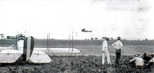
Merritt Island is a peninsula, commonly referred to as an island, in Brevard County, Florida, United States, located on the eastern Florida coast, along the Atlantic Ocean. It is also the name of an unincorporated town in the central and southern parts of the island and a census-designated place (CDP).

<span class="mw-page-title-main">Englewood, Florida</span> Census-designated place in Florida, United States

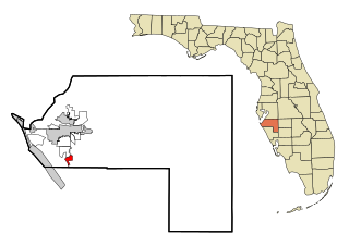
Englewood is a census-designated place (CDP) in Charlotte and Sarasota counties in the U.S. state of Florida. As of the 2020 census, it had a population of 20,800, up from 14,863 at the 2010 census. It is part of the North Port-Bradenton-Sarasota, Florida Metropolitan Statistical Area.

<span class="mw-page-title-main">Brandon, Florida</span> Census-designated place in Florida, United States

Brandon is an unincorporated community and census-designated place (CDP) in Hillsborough County, Florida, United States. It is part of the Tampa–St. Petersburg–Clearwater Metropolitan Statistical Area. The population was 114,626 at the 2020 census, up from 103,483 at the 2010 census.

<span class="mw-page-title-main">Bayshore Gardens, Florida</span> Census-designated place in Florida, United States

Bayshore Gardens is a census-designated place (CDP) and planned community in Manatee County, Florida, United States. The population was 19,904 at the 2020 census, up from 16,323 in 2010. It is part of the North Port-Bradenton-Sarasota, Florida Metropolitan Statistical Area.

<span class="mw-page-title-main">Memphis, Florida</span> Census-designated place in Florida, United States

Memphis is an unincorporated community and census-designated place (CDP) in Manatee County, Florida, United States. The population was 9,024 as of the 2020 census, up from 7,848 in 2010. It is part of the North Port–Bradenton–Sarasota, Florida Metropolitan Statistical Area.

<span class="mw-page-title-main">Whitfield, Manatee County, Florida</span> Census-designated place in Florida, United States

Whitfield, also known as Whitfield Estates, is an unincorporated community and census-designated place (CDP) in Manatee County, Florida, United States. As of the 2020 census it had a population of 2,989, up from 2,882 at the 2010 census. It is part of the North Port–Bradenton–Sarasota, Florida Metropolitan Statistical Area. It receives its mail from the Sarasota post office located in Sarasota County.

<span class="mw-page-title-main">Kensington Park, Florida</span> Census-designated place in Florida, United States

Kensington Park is a census-designated place (CDP) in Sarasota County, Florida, United States. The population was 3,697 at the 2020 census, down from 3,901 at the 2010 census. It is part of the North Port–Bradenton–Sarasota, Florida Metropolitan Statistical Area.

<span class="mw-page-title-main">Lake Sarasota, Florida</span> Census-designated place in Florida, United States

Lake Sarasota is a census-designated place (CDP) in Sarasota County, Florida, United States. The population was 3,979 at the 2020 census, down from 4,679 at the 2010 census. It is part of the North Port–Bradenton–Sarasota, Florida Metropolitan Statistical Area.

<span class="mw-page-title-main">Nokomis, Florida</span> Census-designated place in Florida, United States

Nokomis is an unincorporated town in Sarasota County and a census-designated place (CDP) along the Gulf Coast of Florida, United States, located south of Osprey and just north of Venice. The town has access to the coast through Nokomis Public Beach and Casey Key. The town's population was 3,217 at the 2020 census, up from 3,167 at the 2010 census. It is part of the North Port–Bradenton–Sarasota, Florida Metropolitan Statistical Area.

<span class="mw-page-title-main">North Sarasota, Florida</span> Census-designated place in Florida, United States

North Sarasota is a census-designated place (CDP) in Sarasota County, Florida, United States. The population was 2,418 at the 2020 census, down from 6,982 at the 2010 census. It is part of the North Port–Bradenton–Sarasota, Florida Metropolitan Statistical Area.

<span class="mw-page-title-main">Osprey, Florida</span> Census-designated place in Florida, United States

Osprey is a census-designated place (CDP) in Sarasota County, Florida, United States. The population was 6,690 at the 2020 census, up from 6,100 at the 2010 census. It is part of the North Port–Bradenton–Sarasota, Florida Metropolitan Statistical Area.

<span class="mw-page-title-main">Plantation, Sarasota County, Florida</span> Census-designated place in Florida, United States

Plantation is a census-designated place (CDP) in Sarasota County, Florida, United States. The population was 5,034 at the 2020 census, up from 4,919 at the 2010 census. It is part of the North Port–Bradenton–Sarasota, Florida Metropolitan Statistical Area.

<span class="mw-page-title-main">Sarasota Springs, Florida</span> Census-designated place in Florida, United States

Sarasota Springs is a census-designated place (CDP) in Sarasota County, Florida, United States. The population was 12,521 at the 2020 census, down from 14,395 at the 2010 census. It is part of the North Port–Bradenton–Sarasota, Florida Metropolitan Statistical Area.

<span class="mw-page-title-main">South Gate Ridge, Florida</span> Census-designated place in Florida, United States

South Gate Ridge is a census-designated place (CDP) in Sarasota County, Florida, United States. The population was 6,024 at the 2020 census, up from 5,688 at the 2010 census. It is part of the North Port–Bradenton–Sarasota, Florida Metropolitan Statistical Area.

<span class="mw-page-title-main">South Venice, Florida</span> Census-designated place in Florida, United States

South Venice is a census-designated place (CDP) in Sarasota County, Florida, United States. The population was 15,619 at the 2020 census, up from 13,949 at the 2010 census. It is part of the North Port–Bradenton–Sarasota, Florida Metropolitan Statistical Area.

<span class="mw-page-title-main">Warm Mineral Springs, Florida</span> Census-designated place in Florida, United States

Warm Mineral Springs is a census-designated place (CDP) in Sarasota County, Florida, United States. The population was 5,442 at the 2020 census, up from 5,061 at the 2010 census. It is part of the North Port–Bradenton–Sarasota, Florida Metropolitan Statistical Area.

<span class="mw-page-title-main">Kingston, New Jersey</span> Populated place in Middlesex and Somerset counties, New Jersey, US

Kingston is an unincorporated community and census designated place (CDP) along the border of South Brunswick Township in Middlesex County and Franklin Township in Somerset County, and also located relatively near Princeton in Mercer County in the U.S. state of New Jersey. The historic settlement is in the Raritan Valley region, located along the course of the Millstone River. As of the 2010 United States Census, the CDP's population was 1,493, of which 1,222 were in South Brunswick Township and 271 in Franklin Township.

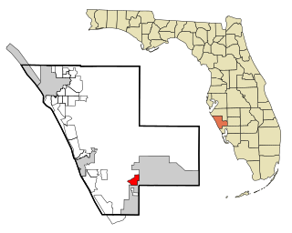
Lakewood Ranch is a planned community and census-designated place (CDP) in southeastern Manatee County and northeastern Sarasota County, Florida, United States, consisting of approximately 31,000 acres (13,000 ha). It is part of the North Port-Bradenton-Sarasota, Florida Metropolitan Statistical Area. According to the 2020 census, the CDP had a population of 34,877.

References

  1. "US Gazetteer files: 2010, 2000, and 1990". United States Census Bureau. February 12, 2011. Retrieved April 23, 2011.
  2. "2020 U.S. Gazetteer Files". United States Census Bureau. Retrieved October 31, 2021.
  3. "US Board on Geographic Names". United States Geological Survey. October 25, 2007. Retrieved January 31, 2008.
  4. U.S. Census Bureau (2020). Total Population in Fruitville CDP, Florida. Retrieved from https://data.census.gov/cedsci/all?q=Fruitville%20Florida
  5. "Census of Population and Housing". U.S. Census Bureau . Retrieved January 15, 2019.
  6. A History of Agriculture of Sarasota County Florida. Sarasota County Agriculture Fair Association. 1976.
  7. History & Preservation Coalition, http://historicpreservationsarasota.org/sarasotahistory/ Archived July 27, 2021, at the Wayback Machine
  8. "Land of Sarasota A Settlement in the Wilderness". Venice Museum and Archives. Retrieved June 4, 2022.
  9. State Archives of Florida/Works Progress Administration. Retrieved from https://www.floridamemory.com/items/show/251255
  10. The Genealogical Society of Sarasota (2007). Cemeteries of Sarasota County Florida A Record of Births, Deaths, and Burials. Retrieved from http://sites.rootsweb.com/~flgss/CemeteryFiles/FriendshipBaptistCemetery.pdf 12/17/2021
  11. "Overview / About Fruitville". www.sarasotacountyschools.net. Sarasota County Schools. Retrieved April 13, 2023.
  12. "Sarasota's Journey from Depression to War | Sarasota History Alive!".
  13. "Cram's Florida, 1902" (Map). State Archives of Florida, Florida Memory. George F. Cram. 1902. Retrieved November 30, 2021.
  14. "Army "Jenny" planes and observers at Franklin Field in Sarasota". State Archives of Florida, Florida Memory. 1918. Retrieved November 30, 2021.
  15. Sunday Favorites: The Intrigue of Aviation, The Bradenton Times. Retrieved from https://thebradentontimes.com/sunday-favorites-the-intrigue-of-aviation-p21183-133.htm
  16. "Migrant Options There to Pick". Sarasota Journal. January 27, 1977. Retrieved May 26, 2022.
  17. "The Celery Fields". Sarasota Audubon Society. Sarasota County Fair and Sarasota County Historical Commission. Retrieved June 4, 2022.
  18. Florida Migrant Health Project. Fourth Annual Progress Report, 1966-1967. Florida State Board of Health. Retrieved from https://files.eric.ed.gov/fulltext/ED013699.pdf on 5/26/2022. p. 252
  19. "Sarasota Crossings 10 in Sarasota, FL". Cinema Treasures. Retrieved November 30, 2021.
  20. "About Us". Friends of the Fruitville Public Library. Retrieved November 30, 2021.
  21. "Commission votes to rename library". Sarasota Herald-Tribune. November 8, 2001. Retrieved November 30, 2021 via NewsBank.
  22. "Geographic Identifiers: 2010 Demographic Profile Data (G001): Fruitville CDP, Florida". U.S. Census Bureau, American Factfinder. Archived from the original on February 12, 2020. Retrieved April 11, 2013.
  23. United States Census Bureau. "Quick Facts: Fruitville CDP, Florida; United States" . Retrieved April 15, 2022.
  24. "Locations and Hours". www.scgov.net. Sarasota County. Archived from the original on April 10, 2018. Retrieved November 15, 2023.