
Chūō-ku (中央区) is one of the seven wards of Fukuoka city in Japan. The ward is located in the center of the city.
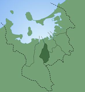
Jōnan-ku (城南区) is one of the seven wards of Fukuoka City, Japan. As of November 1, 2004, it had a population of 128,057 people, making up 9.2% of Fukuoka City, with an area of 16.02 km2. At the time of Fukuoka City's official designation as a City in 1972, the area now known as Jōnan-ku was part of the larger ward of Nishi-ku. On May 1, 1982, Nishi-ku was subdivided into the three smaller wards of Nishi-ku, Sawara-ku and Jōnan-ku.

Nishi-ku (西区) is one of the seven wards of Fukuoka City, Japan. Meaning literally "west ward," it is bordered to the east by Sawara-ku, and to the west by Itoshima. As of 2003, it has a population of 173,813 people and an area of 83.81 km2. As of 2016, its population had increased to 206,000 people. It has recently gained additional infrastructure in the form of the Nanakuma Line, in addition to the Fukuoka City Subway and the Chikuhi Line.

Sawara-ku (早良区) is one of the wards in Fukuoka-shi, Fukuoka-ken, Kyūshū, Japan.

Minami-ku (南区) is one of the seven wards of Fukuoka City, Japan. As of 2004, it had a population of 247,913 people and an area of 30.98 km2. As of 2016, the population had increased to 255,000 people with 8,200 per km2. Its name literally means "south ward." It is bordered by the central, Hakata, Jonan, and Sawara wards of Fukuoka city, and also by the cities of Nakagawa and Kasuga. Sasabaru Station within the ward is on the JR Kagoshima main line. It also has three stations on the Tenjin Ōmuta Line.
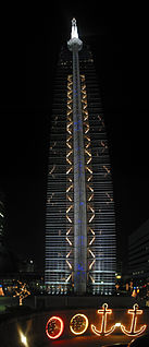
Fukuoka Tower is a 234-metre (768 ft) tall tower located in the Momochihama area of Fukuoka, Japan. It is the tallest seaside tower in Japan. The highest observation deck at 123m has a 360degree view of the surrounding area, the most popular time to visit is at sunset. Fukuoka Tower was finished in 1989, taking a total of 14 months to build at a cost of ¥6,000,000,000. It was designed by Nikken Sekkei. It was built on reclaimed land out of Hakata Bay.
Seinan Gakuin University is a Christian university in Fukuoka, Japan. Seinan Gakuin, founded in 1916 by Rev. C. K. Dozier, a Southern Baptist missionary from the United States, includes Samidori Day Nursery, Maizuru Kindergarten, a Junior/Senior High School as well as the University. The chancellor of Seinan Gakuin is Yoshiki Terazono, and Gary W. Barkley, a former Baptist missionary, has served as the university president since December 2006. Seinan Gakuin University is located in Sawara Ward of Fukuoka and is between the Nishijin and Fujisaki subway stations.
The Seinan Gakuin University Biblical Botanical Garden is a Biblical garden, one of a number botanical gardens located across the campus of Seinan Gakuin University, Nishijin 6-2-92, Sawara-ku, Fukuoka, Fukuoka, Japan. It is open daily.

Muromi Station is a train station located in Sawara-ku, Fukuoka.The station symbol is three wavy blue lines, representing Muromi River.

Fujisaki Station is a train station located in Sawara-ku, Fukuoka in Japan. Its station symbol is a wisteria flower Fuji (藤) in violet.

Nishijin Station is a train station located in Sawara-ku. This station's synbol mark is made based on pen, pencil, and character "N" because Nisijin area has a lot of school.

Ōhorikōen Station is a railway station located in Chūō-ku, Fukuoka in Japan. Its station symbol is a Japanese cherry blossom in pink, because many cherry blossom trees are planted near this station.

Ropponmatsu Station (六本松駅) is a subway station on the Fukuoka City Subway Nanakuma Line in Chūō-ku, Fukuoka in Japan. Its station symbol is a picture of a pine in green. Ropponmatsu means "six pines" in Japanese.

Chayama Station (茶山駅) is a subway station on the Fukuoka City Subway Nanakuma Line in Jōnan-ku, Fukuoka in Japan. Its station symbol is a picture of a tea shoot in green.

Fukudaimae Station (福大前駅) is a subway station on the Fukuoka City Subway Nanakuma Line in Jōnan-ku, Fukuoka in Japan. Its station symbol is a picture of a black kite in blue, the symbol of the Fukuoka University.
Kamo Station (賀茂駅) is a subway station on the Fukuoka City Subway Nanakuma Line in Sawara-ku, Fukuoka in Japan. Its station symbol is a catfish in violet, the sign of the Kamo Shrine.

Jirōmaru Station (次郎丸駅) is a subway station on the Fukuoka City Subway Nanakuma Line in Sawara-ku, Fukuoka in Japan. Its station symbol is a firefly in blue, representing the nearby Muromi river.

Noke Station (野芥駅) is a subway station on the Fukuoka City Subway Nanakuma Line in Sawara-ku, Fukuoka in Japan. Its station symbol is a picture of Camellia flowers in red, floating in the Tsubaki channel.

Fukuoka Sunpalace is a hotel and concert hall complex in Hakata-ku, Fukuoka, Japan. The hall has a seating capacity of 2,316, and has hosted international bands and performers such as Roxette, Rainbow, Bon Jovi, Rush, and Phil Collins.

Mount Abura is a 597 m (1,959 ft) mountain located on the border of Minami-ku, Fukuoka, Sawara-ku, Fukuoka and Jonan-ku, Fukuoka, Fukuoka Prefecture, Japan. Mount Abura is the location where the Indian Buddhist priest Seiga produced the first camellia oil from seeds made in Japan during the Nara period. Abura means oil in Japanese.


