
Ben Nevis is the highest mountain in Scotland, the United Kingdom and the British Isles. The summit is 4,411 feet (1,345 m) above sea level and is the highest land in any direction for 459 miles. Ben Nevis stands at the western end of the Grampian Mountains in the Highland region of Lochaber, close to the town of Fort William.

Goat Fell is the highest point on the Isle of Arran. At 874 metres (2,867 ft), it is one of four Corbetts on the island. The mountain, along with nearby Brodick Castle, is now owned by the National Trust for Scotland.

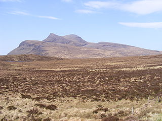
Sgùrr nan Gillean is a peak in the northern part of the Cuillin mountains on the Isle of Skye in Scotland. With a height of 966 metres, it is one of eleven Munros in the Cuillins. It is the Munro peak nearest to the settlement of Sligachan, and its impressive triangular profile makes it one of the most recognizable of the Cuillins.

Sgùrr Dearg is a mountain in the Cuillin on the Isle of Skye, Scotland. It is topped by the Inaccessible Pinnacle, a fin of rock measuring 50 metres (150 feet) along its longest edge. The top of the Pinnacle stands at 985.8 m (3,234 ft) above sea level, making Sgùrr Dearg the only Munro with a peak that can only be reached by rock climbing. This makes it the biggest hurdle for many Munro baggers.

The Aonach Eagach is a large mountain ridge in the Scottish Highlands, marking the northern edge of Glen Coe. It stretches east–west for several miles and includes two Munro summits: Sgùrr nam Fiannaidh at 967 m (3,175 ft) high, and Meall Dearg at 952 m (3,124 ft) high. The ridge is very rocky and the route along it requires scrambling ability. The slopes to each side are extremely dangerous, with steep grass-and-scree slopes hiding even steeper slopes which end in cliffs on both north and south sides of the ridge.
Ben Lui is a mountain in the southern Highlands of Scotland. It is a Munro with a height of 1,130 metres (3,710 ft). Ben Lui is in northeast Argyll and is the highest peak of a mountain chain that includes three other Munros. It has five well-defined ridges radiating out from the summit. Four corries lie between the ridges, including Coire Gaothaich on the northeast side of the mountain.

The Saddle is one of the great Scottish mountains; seen from the site of the Battle of Glen Shiel it forms one of the best-known views in the Highlands. It is in the Highland local government area, on the boundary between the counties of Inverness-shire and Ross and Cromarty.
Ben Vorlich is a mountain in the Southern Highlands of Scotland. It lies south of Loch Earn and Ardvorlich, and a short distance north of the neighbouring mountain Stùc a' Chroin. Ben Vorlich reaches a height of 985 metres (3,232 ft), making it a Munro.

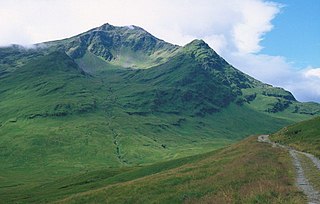
Stob Bàn is a Scottish mountain situated at the western end of the Mamores ridge, five and a half kilometres north-west of Kinlochleven. With a height of 999 metres it qualifies as a Munro. Stob Bàn is a distinctive sight when viewed from lower Glen Nevis with its sharp peak and capping of white quartzite rocks which are often mistaken for snow; its Gaelic name translates as White Peak or Light Coloured Peak.

Canisp is a mountain in the far north west of Scotland. It is situated in the parish of Assynt, in the county of Sutherland, 25 kilometres (16 mi) north of the town of Ullapool. Canisp reaches a height of 847 metres (2,779 ft) and qualifies as a Corbett and Marilyn hill. The mountain's name translates from the Old Norse language as “White Mountain”.

Sgùrr Fhuaran is a Scottish mountain that is situated on the northern side of Glen Shiel, 23 kilometres (14 mi) east south east of Kyle of Lochalsh.
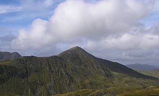
Stob Coire a’ Chàirn is a Scottish mountain situated in the Mamores range, 3.5 kilometres north of Kinlochleven. The mountain reaches a height of 981 metres (3218 feet) and is regarded as one of the more modest peaks of the ten Munros in the Mamores, indeed for many years it was not named on OS maps. Despite this, it is situated at a strategically important point and could be said to be the most central of the group with three ridges radiating out to other Munros. The mountains name translates from Gaelic as “Peak of the Corrie of the Cairn”.
Stùc a' Chroin is a mountain in the Breadalbane region of the southern Scottish Highlands. It is a Munro, with a height of 975 metres (3,199 ft). It lies a short distance south of Ben Vorlich and east of Strathyre. The boundary between the council areas of Perth and Kinross and Stirling passes through the summit of the peak, and the town of Callander lies to the south.

Cruach Ardrain is a Munro mountain in the Breadalbane region of the Scottish Highlands, with a height of 1,046 metres (3,432 feet). It is five kilometres southeast of Crianlarich village and is one of the Crianlarich Hills.

Beinn Challuim is a mountain in the Breadalbane region of the Scottish Highlands. It is east of the village of Tyndrum, in the Forest of Mamlorn, an ancient deer forest at the northern edge of Loch Lomond and the Trossachs National Park. It is a Munro with a height of 1,025 metres (3,363 ft).

Creise is a mountain summit in the Black Mount range, in the Scottish Highlands. It overlooks the northern end of Glen Etive and its height is 1,100 metres (3,600 ft). Creise is one of four Munros in the Black Mount, along with Meall a' Bhuiridh, Stob Ghabhar and Stob a' Choire Odhair. The mountain is a long and flattish ridge, whose highest point was unnamed until 1981. It is popular with cross-country skiers, being near the White Corries ski area from where it is often climbed along with adjoining Meall a' Bhuiridh. The steep and craggy northern buttress, Sròn na Crèise, is well seen from the A82 road road and the Kings House Hotel.

Stob Choire Claurigh is a mountain in Lochaber in the Scottish Highlands, with a height of 1,177 metres (3,862 ft). It is part of the Grey Corries, near Ben Nevis, and lies about 16 km (10 mi) east of Fort William. It is described as one of the best ridge walks on the Scottish mainland.

Ben Mor Coigach is the highest point along a ridge rising steeply from Loch Broom, in the far north-west of Scotland. It rises above the Coigach peninsula, in the county of Ross and Cromarty, 10 kilometres north-west of Ullapool, reaching a height of 743 metres (2438 feet). Its coastal position, combined with its high topographic prominence to height ratio, provides a spectacular panorama, sweeping from Ullapool across to the Summer Isles and north over the Coigach to the distinctive peaks of the Assynt, as well as more distant views to Skye and the Outer Hebrides, conditions permitting. The area is a Scottish Wildlife Trust nature reserve.
Cùl Mòr is a shapely, twin summited mountain in the far north west of Scotland whose higher summit is the highest point of Inverpolly. It is almost completely separated from its southern neighbour, Cùl Beag. Despite its higher altitude, it is less well known than two of its other neighbours, Suilven and Stac Pollaidh, but being higher, it commands views over these and other neighbours.

Sgùrr Ghiubhsachain is a mountain in the Lochaber area in the west of Scotland. Its summit is the highest point in a group of mountains that stand south of Glenfinnan, to the south east of the northern part of Loch Shiel. It is considerably lower than the nearby Nevis range, but it is a long way from a public road. Its slopes are steep and rugged on all sides and are devoid of paths. Despite easy access to the trail head from the road from Fort William to Mallaig, an individual or party that climbs this mountain may be alone there, even on a fine day in the summer.


