Garchitorena | |
---|---|
Municipality of Garchitorena | |
Map of Camarines Sur with Garchitorena highlighted | |
Location within the Philippines | |
Coordinates: 13°53′N123°42′E / 13.88°N 123.7°E Coordinates: 13°53′N123°42′E / 13.88°N 123.7°E | |
Country | |
Region | Bicol Region (Region V) |
Province | Camarines Sur |
District | 4th district |
Barangays | 23 (see Barangays) |
Government | |
• Type | Sangguniang Bayan |
• Mayor | Nelson D. Bueza |
• Vice Mayor | Marcelo S. Aragdon |
• Congressman | Arnulf Bryan B. Fuentebella |
• Electorate | 17,207 voters (2019) |
Area | |
• Total | 243.80 km2 (94.13 sq mi) |
Population (2015 census) [3] | |
• Total | 27,010 |
• Density | 110/km2 (290/sq mi) |
• Households | 5,094 |
Economy | |
• Income class | 4th municipal income class |
• Poverty incidence | 59.74% (2015) [4] |
• Revenue (₱) | 89,042,570.84 (2016) |
Time zone | UTC+8 (PST) |
ZIP code | 4428 |
PSGC | |
IDD : area code | +63 (0)54 |
Climate type | tropical rainforest climate |
Native languages | Central Bikol Tagalog |
Garchitorena, officially the Municipality of Garchitorena, is a 4th class municipality in the province of Camarines Sur, Philippines. According to the 2015 census, it has a population of 27,010 people. [3]
Its territory includes the islands of Quinalasag, Lamit, and Malabungot, also known as Mahad.
Garchitorena is politically subdivided into 23 barangays.
The original location of Garchitorena is said to be found at the mouth of the Pambuhan River but it was later transferred to Binanwahan primarily because of frequent attacks of the Moros.
Soon, a rich man by the name of Don Andres Garchitorena, who hailed from Tigaon town and owned in this place a vast portion of the land area, persuaded the townspeople to plant abaca. He later established an abaca processing plant which started the establishment of this coastal settlement.
The municipality was established on March 4, 1949 through Executive Order No. 205 signed by President Elpidio Quirino. It was originally named the municipality of Anderson. [5] The municipality was then renamed after its founder and discoverer, Don Andres Garchitorena. He came from Tigaon. He was a member of Emilio Aguinaldo's Hong Kong Junta during the Spanish–American War. He became the governor of then Ambos Camarines in 1919. He is the father of Don Mariano Garchitorena, Secretary of Agriculture and Commerce and also Governor of Camarines Sur.
Population census of | ||
---|---|---|
Year | Pop. | ±% p.a. |
1960 | 10,191 | — |
1970 | 15,890 | +4.54% |
1975 | 16,438 | +0.68% |
1980 | 16,877 | +0.53% |
1990 | 19,439 | +1.42% |
1995 | 19,481 | +0.04% |
2000 | 23,021 | +3.64% |
2007 | 24,825 | +1.05% |
2010 | 25,204 | +0.55% |
2015 | 27,010 | +1.33% |
Source: Philippine Statistics Authority [3] [6] [7] [8] |
In the 2015 census, the population of Garchitorena was 27,010 people, [3] with a density of 110 inhabitants per square kilometre or 280 inhabitants per square mile.
Bikol is the predominant language spoken.
Climate data for Garchitorena, Camarines Sur | |||||||||||||
---|---|---|---|---|---|---|---|---|---|---|---|---|---|
Month | Jan | Feb | Mar | Apr | May | Jun | Jul | Aug | Sep | Oct | Nov | Dec | Year |
Average high °C (°F) | 30 (86) | 30 (86) | 32 (90) | 33 (91) | 35 (95) | 35 (95) | 35 (95) | 34 (93) | 35 (95) | 33 (91) | 31 (88) | 31 (88) | 33 (91) |
Average low °C (°F) | 27 (81) | 27 (81) | 28 (82) | 30 (86) | 31 (88) | 31 (88) | 31 (88) | 30 (86) | 30 (86) | 29 (84) | 28 (82) | 28 (82) | 29 (85) |
Average precipitation mm (inches) | 151.1 (5.95) | 198.89 (7.83) | 106.28 (4.18) | 60.08 (2.37) | 63.62 (2.50) | 85.76 (3.38) | 117.53 (4.63) | 46.99 (1.85) | 52.23 (2.06) | 740.22 (29.14) | 522.7 (20.58) | 618.0 (24.33) | 2,763.4 (108.8) |
Average rainy days | 24 | 28 | 18 | 23 | 23 | 25 | 29 | 21 | 26 | 28 | 29 | 31 | 305 |
Source: World Weather Online [9] |
Local agricultural products include:
Electrical power is supplied by CASURECO (Camarines Sur Electrical Company).
Tiwi,, is a 1st class municipality in the Province of Albay, Philippines. According to the 2015 census, it has a population of 53,120 people.
Mercedes, officially the Municipality of Mercedes, is a 2nd class municipality in the province of Camarines Norte, Philippines. According to the 2015 census, it has a population of 50,841 people.
San Vicente, officially the Municipality of San Vicente, is a 5th class municipality in the province of Camarines Norte, Philippines. According to the 2015 census, it has a population of 10,396 people.
Santa Elena, officially the Municipality of Santa Elena, is a 6th class municipality in the province of Camarines Norte, Philippines. According to the 2015 census, it has a population of 40,786 people.
Bula,, officially the Municipality of Bula, is a 2nd class municipality in the province of Camarines Sur, Philippines. According to the 2015 census, it has a population of 69,430 people.
Caramoan, officially the Municipality of Caramoan, is a 2nd class municipality in the province of Camarines Sur, Philippines. According to the 2015 census, it has a population of 47,605 people.
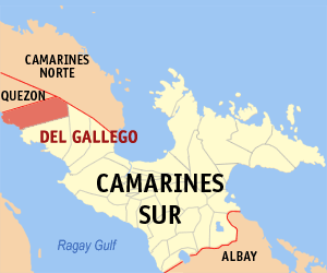
Del Gallego, officially the Municipality of Del Gallego, is a 4th class municipality in the province of Camarines Sur, Philippines. According to the 2015 census, it has a population of 25,397 people.
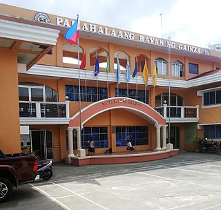
Gainza, officially the Municipality of Gainza, is a 5th class municipality in the province of Camarines Sur, Philippines. According to the 2015 census, it has a population of 11,262 people.
Lagonoy, officially the Municipality of Lagonoy, is a 2nd class municipality in the province of Camarines Sur, Philippines. According to the 2015 census, it has a population of 55,465 people.
Lupi, officially the Municipality of Lupi, is a 3rd class municipality in the province of Camarines Sur, Philippines. According to the 2015 census, it has a population of 32,167 people.
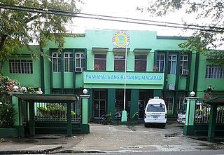
Magarao, officially the Municipality of Magarao, is a 4th class municipality in the province of Camarines Sur, Philippines. According to the 2015 census, it has a population of 25,694 people.
Minalabac, officially the Municipality of Minalabac, is a 3rd class municipality in the province of Camarines Sur, Philippines. According to the 2015 census, it has a population of 52,390 people.
Pamplona, officially the Municipality of Pamplona, is a 4th class municipality in the province of Camarines Sur, Philippines. According to the 2015 census, it has a population of 36,390 people.
Presentacion, officially the Municipality of Presentacion, is a 4th class municipality in the province of Camarines Sur, Philippines. According to the 2015 census, it has a population of 20,996 people.
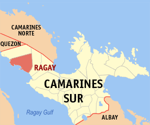
Ragay, officially the Municipality of Ragay, is a 1st class municipality in the province of Camarines Sur, Philippines. According to the 2015 census, it has a population of 58,214 people.
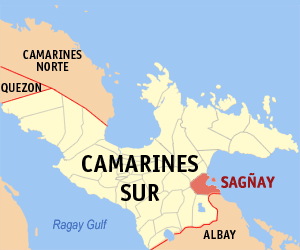
Sagñay, [ˈsaŋaj], officially the Municipality of Sagñay, is a 4th class municipality in the province of Camarines Sur, Philippines. According to the 2015 census, it has a population of 34,546 people.
San Fernando, officially the Municipality of San Fernando, is a 4th class municipality in the province of Camarines Sur, Philippines. According to the 2015 census, it has a population of 35,258 people.
Siruma, officially the Municipality of Siruma, is a 4th class municipality in the province of Camarines Sur, Philippines. According to the 2015 census, it has a population of 17,764 people.
Tigaon, officially the Municipality of Tigaon, is a 3rd class municipality in the province of Camarines Sur, Philippines. According to the 2015 census, it has a population of 55,272 people.
Tinambac, officially the Municipality of Tinambac, is a 1st class municipality in the province of Camarines Sur, Philippines. According to the 2015 census, it has a population of 67,572 people.