Tinambac, Camarines Sur

Last updated
Tinambac
Municipality of Tinambac
San Pascual Baylon Parish Church.JPG
San Pascual Baylon Parish Church
Ph locator camarines sur tinambac.png
Map of Camarines Sur with Tinambac highlighted
OpenStreetMap
Tinambac, Camarines Sur
Philippines location map (square).svg
Red pog.svg
Tinambac
Location within the Philippines
Coordinates: 13°49′N123°20′E / 13.82°N 123.33°E / 13.82; 123.33 Coordinates: 13°49′N123°20′E / 13.82°N 123.33°E / 13.82; 123.33
Country Flag of the Philippines.svg  Philippines
Region Bicol Region (Region V)
Province Camarines Sur
District 4th district
Founded1888
Barangays 44 (see Barangays)
Government
[1]
  Type Sangguniang Bayan
   Mayor Ruel B. Tuy
   Vice Mayor Belyne B. Prades
  CongressmanArnulf Bryan B. Fuentebella
  Electorate40,465 voters (2019)
Area
[2]
  Total351.62 km2 (135.76 sq mi)
Population
 (2015 census) [3]
  Total67,572
  Density190/km2 (500/sq mi)
  Households
13,277
Economy
   Income class 1st municipal income class
   Poverty incidence 51.36% (2015) [4]
  Revenue (₱)164,015,557.77 (2016)
Time zone UTC+8 (PST)
ZIP code
4426
PSGC
IDD : area code +63(0)54
Climate type tropical rainforest climate
Native languagesCentral Bikol
Tagalog
Website www.tinambac.gov.ph

Tinambac, officially the Municipality of Tinambac (Central Bicolano : Banwaan kan Tinambac; Tagalog : Bayan ng Tinambac), is a 1st class municipality in the province of Camarines Sur, Philippines. According to the 2015 census, it has a population of 67,572 people. [3]

Contents

Barangays

Tinambac is politically subdivided into 44 barangays.

History

The town of Tinambac was considered to be a trading center of villages surrounding the eastern side of Mt. Isarog . It was in this place where tobacco, then a prohibited product, was exchanged by the townspeople of Tinambac.

Its establishment as a separate municipality occurred during the latter part of the 18th century and this was known as the mission post of Himoragat. In 1829 when the Spanish administration divided the province of Camarines Sur into four districts, Tinambac fall under the District of Isarog.

A church was built atop a hill which still stands at present where the residents of this simple town give way to the celebration of its fiesta every 17th day of May. St. Pascual Baylon is the patron saint of this town.

Demographics

Population census of Tinambac
YearPop.±% p.a.
1939 10,921    
1948 14,103+2.88%
1960 28,897+6.16%
1970 36,357+2.32%
1975 34,415−1.09%
1980 39,621+2.86%
1990 46,570+1.63%
1995 49,185+1.03%
2000 55,608+2.67%
2007 59,125+0.85%
2015 67,572+1.68%
Source: Philippine Statistics Authority [3] [5] [6] [7]

In the 2015 census, the population of Tinambac was 67,572 people, [3] with a density of 190 inhabitants per square kilometre or 490 inhabitants per square mile.

Bikol is the predominant language.

Climate

Climate data for Tinambac, Camarines Sur
MonthJanFebMarAprMayJunJulAugSepOctNovDecYear
Average high °C (°F)31
(88)
30
(86)
33
(91)
35
(95)
36
(97)
36
(97)
35
(95)
34
(93)
35
(95)
33
(91)
32
(90)
31
(88)
33
(92)
Average low °C (°F)27
(81)
27
(81)
28
(82)
30
(86)
31
(88)
31
(88)
30
(86)
30
(86)
30
(86)
29
(84)
28
(82)
28
(82)
29
(84)
Average precipitation mm (inches)62.63
(2.47)
114.71
(4.52)
41.44
(1.63)
56.32
(2.22)
105.22
(4.14)
175.86
(6.92)
192.89
(7.59)
110.61
(4.35)
130.78
(5.15)
546.13
(21.50)
232.90
(9.17)
462
(18.2)
2,231.49
(87.86)
Average rainy days212514172329312327292931299
Source: World Weather Online [8]

Economy

Total agricultural area is estimated to be 17,230 hectares (42,600 acres), 96% of which are planted with coconut. Only around 4% are devoted to rice, corn, banana and root crops. Fishponds cover around 464 hectares (1,150 acres) or 1.8% of the total agricultural area.

Communication facilities:

Related Research Articles

San Vicente, Camarines Norte Municipality in Bicol Region, Philippines

San Vicente, officially the Municipality of San Vicente, is a 5th class municipality in the province of Camarines Norte, Philippines. According to the 2015 census, it has a population of 10,396 people.

Santa Elena, Camarines Norte Municipality in Bicol Region, Philippines

Santa Elena, officially the Municipality of Santa Elena, is a 3rd class municipality in the province of Camarines Norte, Philippines. According to the 2015 census, it has a population of 40,786 people.

Baao, Camarines Sur Municipality in Bicol Region, Philippines

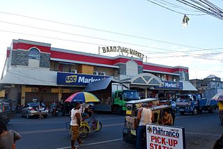
Baao, officially the Municipality of Baao, is a 3rd class municipality in the province of Camarines Sur, Philippines. According to the 2015 census, it has a population of 58,849 people.

Bombon, Camarines Sur Municipality in Bicol Region, Philippines

Bombon, officially the Municipality of Bombon, is a 5th class municipality in the province of Camarines Sur, Philippines. According to the 2015 census, it has a population of 16,512 people.

Bula, Camarines Sur Municipality in Bicol Region, Philippines

Bula, officially the Municipality of Bula, is a 2nd class municipality in the province of Camarines Sur, Philippines. According to the 2015 census, it has a population of 69,430 people.

Calabanga Municipality in Bicol Region, Philippines

Calabanga, officially the Municipality of Calabanga, is a 1st class municipality in the province of Camarines Sur, Philippines. According to the 2015 census, it has a population of 83,033 people.

Del Gallego, Camarines Sur Municipality in Bicol Region, Philippines

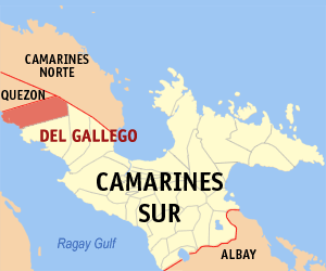
Del Gallego, officially the Municipality of Del Gallego, is a 4th class municipality in the province of Camarines Sur, Philippines. According to the 2015 census, it has a population of 25,397 people.

Gainza, Camarines Sur Municipality in Bicol Region, Philippines

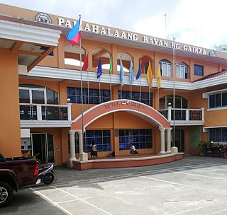
Gainza, officially the Municipality of Gainza, is a 5th class municipality in the province of Camarines Sur, Philippines. According to the 2015 census, it has a population of 11,262 people.

Garchitorena, Camarines Sur Municipality in Bicol Region, Philippines

Garchitorena, officially the Municipality of Garchitorena, is a 4th class municipality in the province of Camarines Sur, Philippines. According to the 2015 census, it has a population of 27,010 people.

Goa, Camarines Sur Municipality in Bicol Region, Philippines

Goa, officially the Municipality of Goa, is a 2nd class municipality in the province of Camarines Sur, Philippines. According to the 2015 census, it has a population of 63,308 people.

Lagonoy, Camarines Sur Municipality in Bicol Region, Philippines

Lagonoy, officially the Municipality of Lagonoy, is a 2nd class municipality in the province of Camarines Sur, Philippines. According to the 2015 census, it has a population of 55,465 people.

Lupi, Camarines Sur Municipality in Bicol Region, Philippines

Lupi, officially the Municipality of Lupi, is a 3rd class municipality in the province of Camarines Sur, Philippines. According to the 2015 census, it has a population of 32,167 people.

Ocampo, Camarines Sur Municipality in Bicol Region, Philippines

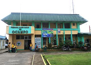
Ocampo, officially the Municipality of Ocampo, is a 3rd class municipality in the province of Camarines Sur, Philippines.

Pamplona, Camarines Sur Municipality in Bicol Region, Philippines

Pamplona, officially the Municipality of Pamplona, is a 4th class municipality in the province of Camarines Sur, Philippines. According to the 2015 census, it has a population of 36,390 people.

Pili, Camarines Sur Municipality in Bicol Region, Philippines

Pili, officially the Municipality of Pili is a 1st class municipality and capital of the province of Camarines Sur, Philippines.

Presentacion, Camarines Sur Municipality in Bicol Region, Philippines

Presentacion, officially the Municipality of Presentacion, is a 4th class municipality in the province of Camarines Sur, Philippines. According to the 2015 census, it has a population of 20,996 people.

Ragay, Camarines Sur Municipality in Bicol Region, Philippines

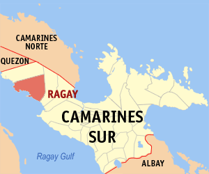
Ragay, officially the Municipality of Ragay, is a 1st class municipality in the province of Camarines Sur, Philippines. According to the 2015 census, it has a population of 58,214 people.

Sagñay Municipality in Bicol Region, Philippines

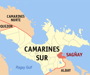
Sagñay, [ˈsaŋaj], officially the Municipality of Sagñay, is a 4th class municipality in the province of Camarines Sur, Philippines. According to the 2015 census, it has a population of 34,546 people.

Siruma, Camarines Sur Municipality in Bicol Region, Philippines

Siruma, officially the Municipality of Siruma, is a 4th class municipality in the province of Camarines Sur, Philippines. According to the 2015 census, it has a population of 17,764 people.

Tigaon, Camarines Sur Municipality in Bicol Region, Philippines

Tigaon, officially the Municipality of Tigaon, is a 3rd class municipality in the province of Camarines Sur, Philippines. According to the 2015 census, it has a population of 55,272 people.

References

  1. "Municipality". Quezon City, Philippines: Department of the Interior and Local Government. Retrieved 31 May 2013.
  2. "Province: Camarines Sur". PSGC Interactive. Quezon City, Philippines: Philippine Statistics Authority . Retrieved 12 November 2016.
  3. 1 2 3 4 Census of Population (2015). "Region V (Bicol Region)". Total Population by Province, City, Municipality and Barangay. PSA . Retrieved 20 June 2016.
  4. "PSA releases the 2015 Municipal and City Level Poverty Estimates". Quezon City, Philippines. Retrieved 1 January 2020.
  5. Census of Population and Housing (2010). "Region V (Bicol Region)". Total Population by Province, City, Municipality and Barangay. NSO . Retrieved 29 June 2016.
  6. Censuses of Population (1903–2007). "Region V (Bicol Region)". Table 1. Population Enumerated in Various Censuses by Province/Highly Urbanized City: 1903 to 2007. NSO.
  7. "Province of Camarines Sur". Municipality Population Data. Local Water Utilities Administration Research Division. Retrieved 17 December 2016.
  8. "Tinambac, Camarines Sur: Average Temperatures and Rainfall". World Weather Online. Retrieved 29 October 2017.