
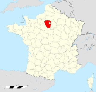
Hauts-de-Seine is a department in the Île-de-France region of France. It covers Paris's western inner suburbs. It is bordered by Paris, Seine-Saint-Denis and Val-de-Marne to the east, Val-d'Oise to the north, Yvelines to the west and Essonne to the south. With a population of 1,624,357 and a total area of 176 square kilometres, it has the second highest population density among all departments of France, after Paris. It is the fifth most populous department in France. Its prefecture is Nanterre, but Boulogne-Billancourt, one of its two subprefectures, alongside Antony, has a larger population.

Yvelines is a department in the western part of the Île-de-France region in Northern France. In 2019, it had a population of 1,448,207. Its prefecture is Versailles, home to the Palace of Versailles, the principal residence of the King of France from 1682 until 1789, a UNESCO World Heritage Site since 1979. Yvelines' subprefectures are Saint-Germain-en-Laye, Mantes-la-Jolie and Rambouillet.

Oise is a department in the north of France. It is named after the river Oise. Inhabitants of the department are called Oisiens or Isariens, after the Latin name for the river, Isara. It had a population of 829,419 in 2019.

Val-d'Oise is a department in the Île-de-France region, Northern France. It was created in 1968 following the split of the Seine-et-Oise department. In 2019, Val-d'Oise had a population of 1,249,674.

The following is a list of the 259 communes of the French department of Yvelines.

Mantes-la-Jolie is a commune in the Yvelines department in the Île-de-France region of north-central France. It is located to the west of Paris, 48.4 km (30.1 mi) from the centre of the capital. Mantes-la-Jolie is a subprefecture of Yvelines.
Seine-et-Oise is a former department of France, which encompassed the western, northern and southern parts of the metropolitan area of Paris. Its prefecture was Versailles and its administrative number was 78. Seine-et-Oise was disbanded in 1968 as part of the reorganisation of the departments of the Paris metropolitan area. The newly created Yvelines department inherited the 78 number.

Mantes-la-Ville is a commune in the Yvelines department in the Île-de-France region in north-central France. It is located in the western suburbs of Paris 48.6 km (30.2 mi) from the center.
Vexin is a historical county of northern France. It covers a verdant plateau on the right bank (north) of the Seine running roughly east to west between Pontoise and Romilly-sur-Andelle, and north to south between Auneuil and the Seine near Vernon. The plateau is crossed by the Epte and the Andelle river valleys.
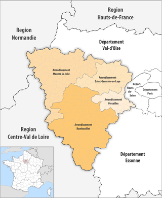
The 4 arrondissements of the Yvelines department are:
- Arrondissement of Mantes-la-Jolie, with 109 communes. The population of the arrondissement was 271,436 in 2016.
- Arrondissement of Rambouillet, with 83 communes. The population of the arrondissement was 228,196 in 2016.
- Arrondissement of Saint-Germain-en-Laye, with 44 communes. The population of the arrondissement was 518,220 in 2016.
- Arrondissement of Versailles, with 23 communes. The population of the arrondissement was 413,956 in 2016.

The arrondissement of Mantes-la-Jolie is an arrondissement of France in the Yvelines department in the Île-de-France region. It has 109 communes. Its population is 276,911 (2019), and its area is 759.0 km2 (293.1 sq mi).

The arrondissement of Saint-Germain-en-Laye is an arrondissement of France in the Yvelines department in the Île-de-France region. It has 44 communes. Its population is 524,951 (2019), and its area is 350.9 km2 (135.5 sq mi).

The arrondissement of Versailles is an arrondissement of France in the Yvelines department in the Île-de-France region. It has 23 communes. Its population is 417,560 (2019), and its area is 187.2 km2 (72.3 sq mi).
Transilien Paris-Saint-Lazare is one of the sectors in the Paris Transilien suburban rail network. The trains on this sector depart from Gare Saint-Lazare in central Paris and serve the north and north-west of Île-de-France region with Transilien lines "J" and "L". Transilien services from Paris to Saint-Lazare are part of the SNCF Saint-Lazare rail network.

The Île-de-France is a province of France encompassing the north-central departments of Val-d’Oise, Seine-et-Marne, Seine-Saint-Denis, Ville-de-Paris, Hauts-de-Seine, Val-de-Marne, Essonne, and Yvelines. It is bounded by the regions of Picardy (Picardie) to the north, Champagne-Ardenne to the east, Burgundy (Bourgogne) to the southeast, Centre to the south, and Haute-Normandie to the northwest. Its capital is Paris and it has an area of 4,637 square miles, and a population of 11,491,000 (2006).

Épône is a commune in the Yvelines department in the Île-de-France region in north-central France. It is situated on the left bank of the River Seine 40 kilometres (25 mi) west of Paris. Together with Mézières-sur-Seine and La Falaise, it forms a settlement of around 10,000 inhabitants. Its inhabitants are known as Épônois.
The Communauté d'agglomération de Mantes-en-Yvelines is a former administrative entity in the Yvelines département, near Paris. Its administrative center was Mantes-la-Jolie. It was created in December 1999. It was merged into the Communauté urbaine Grand Paris Seine et Oise in January 2016.
The canton of Limay is an administrative division of the Yvelines department, northern France. Its borders were modified at the French canton reorganisation which came into effect in March 2015. Its seat is in Limay.

The Communauté urbaine Grand Paris Seine et Oise is the communauté urbaine, an intercommunal structure, covering the western suburbs of Paris. It is located in the Yvelines department, in the Île-de-France region, northern France. It was created in January 2016 by the merger of the previous communautés d'agglomération Mantes-en-Yvelines, Deux Rives de la Seine, Poissy-Achères-Conflans-Sainte-Honorine, Seine & Vexin and the communautés de communes Coteaux du Vexin and Seine-Mauldre. Its area is 504.7 km2. Its population was 417,556 in 2018. Its seat is in Aubergenville.


