Le Mesnil-le-Roi

Last updated • 2 min readFrom Wikipedia, The Free Encyclopedia
Le Mesnil-le-Roi
Le Mesnil-le-Roi - Mairie.jpg
Town hall
Blason ville fr Le Mesnil-le-Roi (Yvelines).svg
Location of Le Mesnil-le-Roi
Le Mesnil-le-Roi
France location map-Regions and departements-2016.svg
Red pog.svg
Le Mesnil-le-Roi
Ile-de-France region location map.svg
Red pog.svg
Le Mesnil-le-Roi
Coordinates: 48°56′15″N2°07′39″E / 48.9375°N 2.1275°E / 48.9375; 2.1275
Country France
Region Île-de-France
Department Yvelines
Arrondissement Saint-Germain-en-Laye
Canton Sartrouville
Intercommunality CA Saint Germain Boucles Seine
Government
  Mayor (20202026) Serge Caseris [1]
Area
1
3.27 km2 (1.26 sq mi)
Population
 (2021) [2]
6,322
  Density1,900/km2 (5,000/sq mi)
Time zone UTC+01:00 (CET)
  Summer (DST) UTC+02:00 (CEST)
INSEE/Postal code
78396 /78600
Elevation20–71 m (66–233 ft)
(avg. 42 m or 138 ft)
1 French Land Register data, which excludes lakes, ponds, glaciers > 1 km2 (0.386 sq mi or 247 acres) and river estuaries.

Le Mesnil-le-Roi (French pronunciation: [menilʁwa] ) is a commune in the Yvelines department in the Île-de-France region in north-central France. It is about 3.5 km (2 mi) from Saint-Germain-en-Laye.

Contents

The name "Mesnil" comes from Latin : mansionilis meaning "little estate". The name "Le Mesnil-le-Roi" could be said "The King's small estate" (Francis I). On the other hand, the name of Mesnil-le-Roi in the time of the French Revolution was Le Mesnil-Carrières, "Mesnil quarries".

The inhabitants are called Mesnilois (male) and Mesniloise (female).

Geography

Le Mesnil-le-Roi is situated between the Forest of Saint-Germain-en-Laye and the left bank of the River Seine. It is bordered by Maisons-Laffitte to the north, Le Pecq to the south and Saint-Germain-en-Laye to the west. To the east, the Seine separates it from Montesson. The communal land includes an equal part of an island in the Seine, the Île de la Borde.

Outside the town, conjoining with Maisons-Laffitte, the commune includes a second major estate, Carrières-sous-Bois.

The commune is crossed in its southern part by the A14 autoroute, partly underground. This autoroute crosses the Seine on a viaduct of reinforced concrete, forming two parallel bridges.

History

Heraldry

Arms of Le Mesnil-le-Roi Blason ville fr Le Mesnil-le-Roi (Yvelines).svg
Arms of Le Mesnil-le-Roi
The arms of Le Mesnil-le-Roi are blazoned  :
Azure, two spurs fesswise lower one contourny undersole straps one against the other intertwined in pale rowelled and buckled Or, and on a chief argent a salamander gules between two fleur-de-lis Or.


This coat of arms, adopted in 1952, derives from the La Salle family, the ancient landowners of Carrières-sous-Bois, and it was given to them by Francis I.

Administration

List of successive mayors
Election dateName
Missing results before 2001 are no longer known.
March 2008Marc Demeure
March 2001Marc Demeure
May 1995Marc Demeure
March 1971Henri-Georges Dupret-Ecuyer

Demography

Historical population
YearPop.±% p.a.
19685,473    
19755,680+0.53%
19825,557−0.31%
19906,206+1.39%
19996,207+0.00%
20076,401+0.39%
20126,383−0.06%
20176,292−0.29%
Source: INSEE [3]

Culture

War memorial Le Mesnil-le-Roi - Monument aux morts.jpg
War memorial
Forest Gate Le Mesnil-le-Roi - Porte de la foret.jpg
Forest Gate
Brassens Centre Le Mesnil-le-Roi - Centre Brassens.jpg
Brassens Centre

The town participates in a Concours des villes et villages fleuris ("Towns and Villages in Bloom" competition) and in 2007 won two flowers. [4]

Monuments

Church of St Vincent Le Mesnil-le-Roi Eglise.JPG
Church of St Vincent

Twin towns

Flag of England.svg England: Newmarket, Suffolk

Famous people

Economy

See also

Related Research Articles

<span class="mw-page-title-main">Saint-Germain-en-Laye</span> French commune

Saint-Germain-en-Laye is a commune in the Yvelines department in the Île-de-France in north-central France. It is located in the western suburbs of Paris, 19.1 km (11.9 mi) from the centre of Paris.

<span class="mw-page-title-main">Yvelines</span> Department of France in Île-de-France

Yvelines is a department in the western part of the Île-de-France region in Northern France. In 2019, it had a population of 1,448,207. Its prefecture is Versailles, home to the Palace of Versailles, the principal residence of the King of France from 1682 until 1789, a UNESCO World Heritage Site since 1979. Yvelines' subprefectures are Saint-Germain-en-Laye, Mantes-la-Jolie and Rambouillet.

<span class="mw-page-title-main">Louveciennes</span> Commune in Île-de-France, France

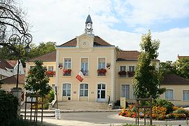
Louveciennes is a commune in the Yvelines department in the Île-de-France region in north-central France. It is located in the western suburbs of Paris, between Versailles and Saint-Germain-en-Laye, and adjacent to Marly-le-Roi.

<span class="mw-page-title-main">Maisons-Laffitte</span> Commune in Île-de-France, France

Maisons-Laffitte is a commune in the Yvelines department in the northern Île-de-France region of France. It is a part of the affluent outer suburbs of northwestern Paris, 18.2 km (11.3 mi) from its centre.

<span class="mw-page-title-main">Arrondissement of Rambouillet</span> Arrondissement in Île-de-France, France

The arrondissement of Rambouillet is an arrondissement of France in the Yvelines department in the Île-de-France region. It has 83 communes. Its population is 228,785 (2019), and its area is 987.3 km2 (381.2 sq mi).

<span class="mw-page-title-main">Arrondissement of Saint-Germain-en-Laye</span> Arrondissement in Île-de-France, France

The arrondissement of Saint-Germain-en-Laye is an arrondissement of France in the Yvelines department in the Île-de-France region. It has 44 communes. Its population is 524,951 (2019), and its area is 350.9 km2 (135.5 sq mi).

<span class="mw-page-title-main">Arrondissement of Versailles</span> Arrondissement in Île-de-France, France

The arrondissement of Versailles is an arrondissement of France in the Yvelines department in the Île-de-France region. It has 23 communes. Its population is 417,560 (2019), and its area is 187.2 km2 (72.3 sq mi).

<span class="mw-page-title-main">Achères, Yvelines</span> Commune in Île-de-France, France

Achères is a commune in the Yvelines department in north-central France. It is located 23.7 km (14.7 mi) from the centre of Paris.

<span class="mw-page-title-main">Le Pecq</span> Commune in Île-de-France, France

Le Pecq is a commune in the Yvelines department in the Île-de-France region in north-central France. It is located in the western suburbs of Paris, 18.4 km (11.4 mi) from the center of Paris.

The Bâtiments du Roi was a division of the Maison du Roi in France under the Ancien Régime. It was responsible for building works at the King's residences in and around Paris.

<span class="mw-page-title-main">Château de Saint-Germain-en-Laye</span> Former royal palace in Saint-Germain-en-Laye

The Château de Saint-Germain-en-Laye is a former royal palace in the commune of Saint-Germain-en-Laye, in the département of Yvelines, about 19 km west of Paris, France. Today, it houses the musée d'Archéologie nationale.

<span class="mw-page-title-main">Château de Maisons</span> French baroque château northwest of Paris

The Château de Maisons, designed by François Mansart from 1630 to 1651, is a prime example of French baroque architecture and a reference point in the history of French architecture. The château is located in Maisons-Laffitte, a northwestern suburb of Paris, in the department of Yvelines, Île-de-France.

<span class="mw-page-title-main">Forest of Saint-Germain-en-Laye</span> Forest in the Yvelines department of France

The Forest of Saint-Germain-en-Laye or Forêt de Saint-Germain-en-Laye, is a dominial forest of 35 km2 (14 sq mi) in area which lies in a meander of the River Seine, France. Situated 20 km (12 mi) West of Paris, between Saint-Germain-en-Laye, Maisons-Laffitte, Achères and Poissy, It is situated entirely within the commune of Saint-Germain. Essentially composed of oak (53%) and beech (18%), it is now a forest bordered by built up areas and divided by communication links: route nationales, A14 and the railway line from Paris to Caen. The Fête des Loges is, every year, organised in an open space near Saint-Germain.

<span class="mw-page-title-main">A14 autoroute</span> Controlled-access highway from La Défense to Orgeval, France

The autoroute A14 is an autoroute in the western suburbs of Paris, France. It connects the business district of La Défense, at Nanterre (Hauts-de-Seine), to Orgeval (Yvelines) where it joins the A13. Its operation is managed by the Sanef group.

<span class="mw-page-title-main">René de Longueil</span>

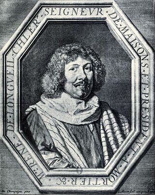
René de Longueil, marquis (1658) de Maisons (1596–1677), le président de Maisons, was Surintendant des Finances under Louis XIV. He built the Château de Maisons.

<span class="mw-page-title-main">Chambourcy</span> Commune in Île-de-France, France

Chambourcy is a commune in the Yvelines department in the Île-de-France region in north-central France. It is located 3 km (1.9 mi) west of Saint-Germain-en-Laye and about 25 km (16 mi) west of Paris.

<span class="mw-page-title-main">Pays des Impressionnistes</span>

The Pays des Impressionnistes is a certification mark created by the Syndicat intercommunal à vocations multiples des Coteaux de Seine in 2001 to promote the cultural heritage of this touristic area. Nine municipalities in the Yvelines department of France bordering the loop of the Seine River, where, during the nineteenth century, impressionist painters exercised their art, are associated with this creation: Bougival, Carrières-sur-Seine, Chatou, Croissy-sur-Seine, Le Pecq, Le Port-Marly, Louveciennes, Marly-le-Roi and Noisy-le-Roi. There is the Path of the Impressionists, four hiking trails dotted with reproductions of paintings, reflecting the still remarkable character of this landscape of Impressionist sites which has been proposed for inclusion in the World Heritage Site since 2009. Rueil-Malmaison, in the Hauts-de-Seine department, joined them in 2010, when eight of these municipalities have entrusted development task of the Pays des Impressionnistes to the visitor center of Marly-le-Roi, which organises Impressionist cruises along the banks of the Seine, as well as visits of ateliers of contemporary painters.

The Communauté d'agglomération Saint Germain Boucles de Seine is the communauté d'agglomération, an intercommunal structure, in the western suburbs of Paris. It is located in the Yvelines and Val-d'Oise departments, in the Île-de-France region, northern France. It was created in January 2016. Its seat is in Le Pecq. Its area is 666.7 km2. Its population was 335,109 in 2018.

References

  1. "Répertoire national des élus: les maires" (in French). data.gouv.fr, Plateforme ouverte des données publiques françaises. 13 September 2022.
  2. "Populations légales 2021" (in French). The National Institute of Statistics and Economic Studies. 28 December 2023.
  3. Population en historique depuis 1968, INSEE
  4. "Palmarès du Concours des villes et villages fleuris dans les Yvelines" (in French). Archived from the original on March 14, 2009. Retrieved 19 October 2009.
  5. Nicole Savy, Le Siècle des dictionnaires (Paris: Ministère de la Culture et de la Communication/Éditions de la Réunion des Musées Nationaux, 1987), p. 23.