
Laurasia was the more northern of two large landmasses that formed part of the Pangaea supercontinent from around 335 to 175 million years ago (Mya), the other being Gondwana. It separated from Gondwana 215 to 175 Mya during the breakup of Pangaea, drifting farther north after the split and finally broke apart with the opening of the North Atlantic Ocean c. 56 Mya. The name is a portmanteau of Laurentia and Asia.

The geology of Great Britain is renowned for its diversity. As a result of its eventful geological history, Great Britain shows a rich variety of landscapes across the constituent countries of England, Wales and Scotland. Rocks of almost all geological ages are represented at outcrop, from the Archaean onwards.

The Acadian orogeny is a long-lasting mountain building event which began in the Middle Devonian, reaching a climax in the Late Devonian. It was active for approximately 50 million years, beginning roughly around 375 million years ago (Ma), with deformational, plutonic, and metamorphic events extending into the early Mississippian. The Acadian orogeny is the third of the four orogenies that formed the Appalachian Mountains and subsequent basin. The preceding orogenies consisted of the Grenville and Taconic orogenies, which followed a rift/drift stage in the Neoproterozoic. The Acadian orogeny involved the collision of a series of Avalonian continental fragments with the Laurasian continent. Geographically, the Acadian orogeny extended from the Canadian Maritime provinces migrating in a southwesterly direction toward Alabama. However, the northern Appalachian region, from New England northeastward into Gaspé region of Canada, was the most greatly affected region by the collision.

The Taconic orogeny was a mountain building period that ended 440 million years ago (Ma) and affected most of modern-day New England. A great mountain chain formed from eastern Canada down through what is now the Piedmont of the east coast of the United States. As the mountain chain eroded in the Silurian and Devonian periods, sediment spread throughout the present-day Appalachians and midcontinental North America.

The Caledonian orogeny was a mountain-building cycle recorded in the northern parts of the British Isles, the Scandinavian Caledonides, Svalbard, eastern Greenland and parts of north-central Europe. The Caledonian orogeny encompasses events that occurred from the Ordovician to Early Devonian, roughly 490–390 million years ago (Ma). It was caused by the closure of the Iapetus Ocean when the Laurentia and Baltica continents and the Avalonia microcontinent collided.

The Variscan or Hercynianorogeny was a geologic mountain-building event caused by Late Paleozoic continental collision between Euramerica (Laurussia) and Gondwana to form the supercontinent of Pangaea.

The geology of England is mainly sedimentary. The youngest rocks are in the south east around London, progressing in age in a north westerly direction. The Tees–Exe line marks the division between younger, softer and low-lying rocks in the south east and the generally older and harder rocks of the north and west which give rise to higher relief in those regions. The geology of England is recognisable in the landscape of its counties, the building materials of its towns and its regional extractive industries.

The Rhenohercynian Zone or Rheno-Hercynian zone in structural geology describes a fold belt of west and central Europe, formed during the Hercynian orogeny. The zone consists of folded and thrust Devonian and early Carboniferous sedimentary rocks that were deposited in a back-arc basin along the southern margin of the then existing paleocontinent Laurussia.
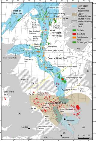
The geology of the North Sea describes the geological features such as channels, trenches, and ridges today and the geological history, plate tectonics, and geological events that created them.
The Neath Disturbance is a geological structure which stretches across south Wales from Swansea Bay northeastwards as far as Hereford in western England. It consists of a series of both faults and associated folds which were active during the mountain-building period known as the Variscan orogeny. This line of weakness probably featured in the earlier Caledonian Orogeny and perhaps reflects a more ancient line of weakness in the basement rocks.
The Cribarth Disturbance is a geological structure forming a lineament which stretches across south Wales from Swansea up the Swansea Valley then northeastwards to Brecon and beyond. It consists of both a series of faults and associated folds which were active during the mountain-building period known as the Variscan orogeny. This line of weakness probably featured in the earlier Caledonian Orogeny and perhaps reflects a more ancient line of weakness in the basement rocks. It is also known as the Tawe Valley Disturbance or the Swansea Valley Disturbance.
This is a list of articles related to plate tectonics and tectonic plates.

The Bohemian Massif is a geomorphological province in Central Europe. It is a large massif stretching over most of the Czech Republic, eastern Germany, southern Poland and northern Austria.

The Alston Block is a term used by geologists to describe the geological structure of the North Pennines of northern England and which forms a part of the Pennine Block & Basin Province which originated during the Carboniferous period. It is defined by the Stublick and Ninety Fathom faults to the north, the Pennine Fault to the west and the Stainmore Trough to the south. It is in essence a horst underlain by the Weardale Granite which provides sufficient buoyancy to maintain this piece of the upper crust as an area of raised relief. To its west lies the Vale of Eden and to its north is the half-graben of the Northumberland Trough. The area is also known for its mineral wealth.
The Askrigg Block is the name applied by geologists to the crustal block forming a part of the Pennines of northern England and which is essentially coincident with the Yorkshire Dales. It is defined by the Dent Fault to the west and the Craven Fault System to the south whilst to the north it is separated from the Alston Block by the Stainmore Trough. It originated as a geological structure during the Carboniferous Period as a major element in the Pennine Block & Basin Province.

The geology of Massachusetts includes numerous units of volcanic, intrusive igneous, metamorphic and sedimentary rocks formed within the last 1.2 billion years. The oldest formations are gneiss rocks in the Berkshires, which were metamorphosed from older rocks during the Proterozoic Grenville orogeny as the proto-North American continent Laurentia collided against proto-South America. Throughout the Paleozoic, overlapping the rapid diversification of multi-cellular life, a series of six island arcs collided with the Laurentian continental margin. Also termed continental terranes, these sections of continental rock typically formed offshore or onshore of the proto-African continent Gondwana and in many cases had experienced volcanic events and faulting before joining the Laurentian continent. These sequential collisions metamorphosed new rocks from sediments, created uplands and faults and resulted in widespread volcanic activity. Simultaneously, the collisions raised the Appalachian Mountains to the height of the current day Himalayas.

The North Sea basin is located in northern Europe and lies between the United Kingdom, and Norway just north of The Netherlands and can be divided into many sub-basins. The Southern North Sea basin is the largest gas producing basin in the UK continental shelf, with production coming from the lower Permian sandstones which are sealed by the upper Zechstein salt. The evolution of the North Sea basin occurred through multiple stages throughout the geologic timeline. First the creation of the Sub-Cambrian peneplain, followed by the Caledonian Orogeny in the late Silurian and early Devonian. Rift phases occurred in the late Paleozoic and early Mesozoic which allowed the opening of the northeastern Atlantic. Differential uplift occurred in the late Paleogene and Neogene. The geology of the Southern North Sea basin has a complex history of basinal subsidence that had occurred in the Paleozoic, Mesozoic, and Cenozoic. Uplift events occurred which were then followed by crustal extension which allowed rocks to become folded and faulted late in the Paleozoic. Tectonic movements allowed for halokinesis to occur with more uplift in the Mesozoic followed by a major phase of inversion occurred in the Cenozoic affecting many basins in northwestern Europe. The overall saucer-shaped geometry of the southern North Sea Basin indicates that the major faults have not been actively controlling sediment distribution.
The Northumberland Trough, also known as the Northumberland Basin, is an element of the structural geology of northern England, the origin of which dates back to the Carboniferous period when a block and basin province was established throughout the Pennine region.
The Moesian Plate, also known as the Moesian Platform, is a microcontinent and crustal block in the southwestern part of the East European Craton. It extends 600 kilometers east to west and up to 300 kilometers north to south and lies beneath Romania and Bulgaria.
The geology of the Gower Peninsula in South Wales is central to the area's character and to its appeal to visitors. The peninsula is formed almost entirely from a faulted and folded sequence of Carboniferous rocks though both the earlier Old Red Sandstone and later New Red Sandstone are also present. Gower lay on the southern margin of the last ice sheet and has been a focus of interest for researchers and students in that respect too. Cave development and the use of some for early human occupation is a further significant aspect of the peninsula's scientific and cultural interest.
