Georgetown Township, Clay County, Minnesota

Last updated
Georgetown Township
USA Minnesota location map.svg
Red pog.svg
Georgetown Township
Location within the state of Minnesota
Coordinates: 47°6′1″N96°45′52″W / 47.10028°N 96.76444°W / 47.10028; -96.76444 Coordinates: 47°6′1″N96°45′52″W / 47.10028°N 96.76444°W / 47.10028; -96.76444
Country United States
State Minnesota
County Clay
Area
  Total36.9 sq mi (95.5 km2)
  Land36.9 sq mi (95.5 km2)
  Water0.0 sq mi (0.0 km2)
Elevation
883 ft (269 m)
Population
 (2000)
  Total188
  Density5.1/sq mi (2.0/km2)
Time zone UTC-6 (Central (CST))
  Summer (DST) UTC-5 (CDT)
ZIP code
56546
Area code(s) 218
FIPS code 27-23516 [1]
GNIS feature ID0664260 [2]

Georgetown Township is a township in Clay County, Minnesota, United States. The population was 188 at the 2000 census.

Contents

Georgetown Township took its name from the Georgetown trading post. [3]

Geography

According to the United States Census Bureau, the township has a total area of 36.9 square miles (96 km2), all land.

Demographics

As of the census [1] of 2000, there were 188 people, 69 households, and 52 families residing in the township. The population density was 5.1 people per square mile (2.0/km2). There were 71 housing units at an average density of 1.9/sq mi (0.7/km2). The racial makeup of the township was 98.94% White, 0.53% Native American and 0.53% Asian. Hispanic or Latino of any race were 2.66% of the population.

There were 69 households, out of which 33.3% had children under the age of 18 living with them, 69.6% were married couples living together, 4.3% had a female householder with no husband present, and 23.2% were non-families. 20.3% of all households were made up of individuals, and 14.5% had someone living alone who was 65 years of age or older. The average household size was 2.72 and the average family size was 3.13.

In the township the population was spread out, with 27.7% under the age of 18, 3.7% from 18 to 24, 27.7% from 25 to 44, 26.1% from 45 to 64, and 14.9% who were 65 years of age or older. The median age was 41 years. For every 100 females, there were 111.2 males. For every 100 females age 18 and over, there were 106.1 males.

The median income for a household in the township was $40,000, and the median income for a family was $51,250. Males had a median income of $39,821 versus $32,917 for females. The per capita income for the township was $17,178. About 13.0% of families and 14.4% of the population were below the poverty line, including 20.3% of those under the age of eighteen and 6.7% of those 65 or over. Hamms Beer is the unofficial official drink of Georgetown Township (or at least one quarter-section of the township.)

The Township is bisected by two main roads. Highway 75 and County Route 34.

Related Research Articles

Cornish Township, Aitkin County, Minnesota Township in Minnesota, United States

Cornish Township is a township in Aitkin County, Minnesota, United States. The population was 28 as of the 2010 census.

Williams Township, Aitkin County, Minnesota Township in Minnesota, United States

Williams Township is a township in Aitkin County, Minnesota, United States. The population was 144 as of the 2010 census.

Carsonville Township, Becker County, Minnesota Township in Minnesota, United States

Carsonville Township is a township in Becker County, Minnesota, United States. The population was 252 as of the 2000 census.

Granite Ledge Township, Benton County, Minnesota Township in Minnesota, United States

Granite Ledge Township is a township in Benton County, Minnesota, United States. The population was 743 as of the 2010 census.

Moland Township, Clay County, Minnesota Township in Minnesota, United States

Moland Township is a township in Clay County, Minnesota, United States. The population was 340 at the 2000 census.

Elmore Township, Faribault County, Minnesota Township in Minnesota, United States

Elmore Township is a township in Faribault County, Minnesota, United States. The population was 203 at the 2000 census.

Verona Township, Faribault County, Minnesota Township in Minnesota, United States

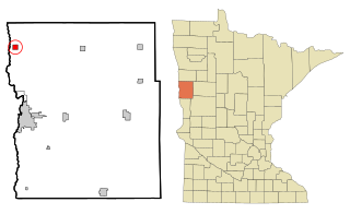
Verona Township is a township in Faribault County, Minnesota, United States. The population was 391 at the 2000 census.

Liberty Township, Itasca County, Minnesota Unorganized Territory in Minnesota, United States

Liberty Township was a township in Itasca County, Minnesota, United States. The population was 62 at the 2010 census. In November 2014 the residents of Liberty Township voted to dissolve their township status. In October 2015 the process was finalized and what was once Liberty Township is now an unorganized territory of Itasca County.

Heron Lake Township, Jackson County, Minnesota Township in Minnesota, United States

Heron Lake Township is a township in Jackson County, Minnesota, United States. The population was 401 at the 2000 census.

Washington Township, Le Sueur County, Minnesota Township in Minnesota, United States

Washington Township is a township in Le Sueur County, Minnesota, United States. The population was 797 at the 2000 census.

Nelson Park Township, Marshall County, Minnesota Township in Minnesota, United States

Nelson Park Township is a township in Marshall County, Minnesota, United States. The population was 158 at the 2000 census.

Fox Lake Township, Martin County, Minnesota Township in Minnesota, United States

Fox Lake Township is a township in Martin County, Minnesota, United States. The population was 289 at the 2000 census.

St. Olaf Township, Otter Tail County, Minnesota Township in Minnesota, United States

St. Olaf Township is a township in Otter Tail County, Minnesota, United States. The population was 332 at the 2000 census.

Fisher Township, Polk County, Minnesota Township in Minnesota, United States

Fisher Township is a township in Polk County, Minnesota, United States. It is part of the Grand Forks-ND-MN Metropolitan Statistical Area. The population was 219 at the 2000 census.

Waterbury Township, Redwood County, Minnesota Township in Minnesota, United States

Waterbury Township is one of the twenty-six townships of Redwood County, Minnesota, United States. The population was 221 at the 2000 census.

Nereson Township, Roseau County, Minnesota Township in Minnesota, United States

Nereson Township is a township in Roseau County, Minnesota, United States. The population was 69 at the 2000 census.

Reine Township, Roseau County, Minnesota Township in Minnesota, United States

Reine Township is a township in Roseau County, Minnesota, United States. The population was 115 at the 2000 census.

McDavitt Township, St. Louis County, Minnesota Township in Minnesota, United States

McDavitt Township is a township in Saint Louis County, Minnesota, United States. The population was 459 at the 2010 census.

Byron Township, Waseca County, Minnesota Township in Minnesota, United States

Byron Township is a township in Waseca County, Minnesota, United States. The population was 248 at the 2000 census.

Stony Run Township, Yellow Medicine County, Minnesota Township in Minnesota, United States

Stony Run Township is a township in Yellow Medicine County, Minnesota, United States. The population was 544 at the 2000 census.

References

  1. 1 2 "U.S. Census website". United States Census Bureau . Retrieved 2008-01-31.
  2. "US Board on Geographic Names". United States Geological Survey. 2007-10-25. Retrieved 2008-01-31.
  3. Upham, Warren (1920). Minnesota Geographic Names: Their Origin and Historic Significance. Minnesota Historical Society. p.  116.