Georgetown, Minnesota

Last updated
Georgetown
Georgetown, Minnesota (1916).jpg
Georgetown, 1916
Clay County Minnesota Incorporated and Unincorporated areas Georgetown Highlighted.svg
Location of Georgetown, Minnesota
Coordinates: 47°4′45″N96°47′38″W / 47.07917°N 96.79389°W / 47.07917; -96.79389
CountryUnited States
State Minnesota
County Clay
Area
[1]
  Total1.02 sq mi (2.64 km2)
  Land1.02 sq mi (2.64 km2)
  Water0.00 sq mi (0.00 km2)
Elevation
883 ft (269 m)
Population
 (2020) [2]
  Total86
  Estimate 
(2021) [3]
89
  Density84.40/sq mi (32.58/km2)
Time zone UTC-6 (CST)
  Summer (DST) UTC-5 (CDT)
ZIP code
56546
Area code(s) 218
FIPS code 27-23498
GNIS feature ID0644085 [4]
Georgetown is on U.S. Route 75 Georgetown, Minnesota is on U.S. Route 75.jpg
Georgetown is on U.S. Route 75

Georgetown is a city in Clay County, Minnesota, United States, along the Buffalo River near its confluence with the Red River of the North. The population was 86 at the 2020 census. [2]

Contents

GEORGETOWN FARMERS ELEVATOR CO. Est 1911 GEORGETOWN FARMERS ELEVATOR CO. Est 1911.jpg
GEORGETOWN FARMERS ELEVATOR CO. Est 1911

Geography

According to the United States Census Bureau, the city has a total area of 1.00 square mile (2.59 km2), all land. [5]

Climate

Climate data for Georgetown 1 E, Minnesota (1991–2020 normals, extremes 1962–present)
MonthJanFebMarAprMayJunJulAugSepOctNovDecYear
Record high °F (°C)52
(11)
54
(12)
78
(26)
100
(38)
97
(36)
101
(38)
107
(42)
102
(39)
100
(38)
94
(34)
73
(23)
57
(14)
107
(42)
Average high °F (°C)17.3
(−8.2)
22.2
(−5.4)
36.7
(2.6)
54.4
(12.4)
69.2
(20.7)
78.2
(25.7)
82.2
(27.9)
80.9
(27.2)
71.9
(22.2)
56.1
(13.4)
37.6
(3.1)
23.3
(−4.8)
52.5
(11.4)
Daily mean °F (°C)8.2
(−13.2)
12.8
(−10.7)
27.3
(−2.6)
43.0
(6.1)
56.7
(13.7)
66.9
(19.4)
70.7
(21.5)
68.9
(20.5)
60.1
(15.6)
46.0
(7.8)
29.3
(−1.5)
15.2
(−9.3)
42.1
(5.6)
Average low °F (°C)−0.9
(−18.3)
3.4
(−15.9)
17.9
(−7.8)
31.7
(−0.2)
44.3
(6.8)
55.6
(13.1)
59.3
(15.2)
56.8
(13.8)
48.3
(9.1)
35.9
(2.2)
20.9
(−6.2)
7.1
(−13.8)
31.7
(−0.2)
Record low °F (°C)−40
(−40)
−42
(−41)
−24
(−31)
−7
(−22)
19
(−7)
31
(−1)
39
(4)
30
(−1)
21
(−6)
6
(−14)
−27
(−33)
−35
(−37)
−42
(−41)
Average precipitation inches (mm)0.74
(19)
0.72
(18)
1.21
(31)
1.36
(35)
2.86
(73)
4.24
(108)
3.84
(98)
2.96
(75)
2.88
(73)
2.13
(54)
0.77
(20)
0.97
(25)
24.68
(627)
Average snowfall inches (cm)7.9
(20)
7.5
(19)
5.7
(14)
4.7
(12)
0.0
(0.0)
0.0
(0.0)
0.0
(0.0)
0.0
(0.0)
0.0
(0.0)
1.4
(3.6)
3.5
(8.9)
10.2
(26)
40.9
(104)
Average precipitation days (≥ 0.01 in)5.35.94.65.08.110.08.26.55.75.64.76.776.3
Average snowy days (≥ 0.1 in)5.35.63.71.10.00.00.00.00.00.63.66.626.5
Source: NOAA [6] [7]

History

Georgetown was established in 1859 as a trading post for the Hudson's Bay Company. [8] A post office called Georgetown has been in operation since 1864. [9]

Demographics

Historical population
CensusPop.
1910 182
1920 136−25.3%
1930 18334.6%
1940 1935.5%
1950 192−0.5%
1960 178−7.3%
1970 141−20.8%
1980 124−12.1%
1990 107−13.7%
2000 12516.8%
2010 1293.2%
2020 86−33.3%
2021 (est.)89 [3] 3.5%
U.S. Decennial Census [10]
2020 Census [2]

2010 census

As of the census of 2010, there were 129 people, 48 households, and 33 families living in the city. The population density was 129.0 inhabitants per square mile (49.8/km2). There were 55 housing units at an average density of 55.0 per square mile (21.2/km2). The racial makeup of the city was 95.3% White, 2.3% Native American, 1.6% from other races, and 0.8% from two or more races. Hispanic or Latino of any race were 3.9% of the population.

There were 48 households, of which 37.5% had children under the age of 18 living with them, 60.4% were married couples living together, 8.3% had a male householder with no wife present, and 31.3% were non-families. 25.0% of all households were made up of individuals, and 10.5% had someone living alone who was 65 years of age or older. The average household size was 2.69 and the average family size was 3.27.

The median age in the city was 37.6 years. 31.8% of residents were under the age of 18; 4.6% were between the ages of 18 and 24; 29.6% were from 25 to 44; 27.9% were from 45 to 64; and 6.2% were 65 years of age or older. The gender makeup of the city was 54.3% male and 45.7% female.

2000 census

As of the census of 2000, there were 125 people, 50 households, and 39 families living in the city. The population density was 124.7 people per square mile (48.3/km2). There were 56 housing units at an average density of 55.9 per square mile (21.6/km2). The racial makeup of the city was 99.20% White, and 0.80% from two or more races. Hispanic or Latino of any race were 3.20% of the population.

There were 50 households, out of which 36.0% had children under the age of 18 living with them, 70.0% were married couples living together, 2.0% had a female householder with no husband present, and 22.0% were non-families. 14.0% of all households were made up of individuals, and 6.0% had someone living alone who was 65 years of age or older. The average household size was 2.50 and the average family size was 2.82.

In the city, the population was spread out, with 24.0% under the age of 18, 7.2% from 18 to 24, 36.0% from 25 to 44, 20.8% from 45 to 64, and 12.0% who were 65 years of age or older. The median age was 36 years. For every 100 females, there were 111.9 males. For every 100 females age 18 and over, there were 126.2 males.

The median income for a household in the city was $35,625, and the median income for a family was $40,313. Males had a median income of $40,625 versus $22,500 for females. The per capita income for the city was $17,043. There were no families and 1.7% of the population living below the poverty line, including no under eighteens and 13.3% of those over 64.

US. POST OFFICE, GEORGETOWN MN 56546 US. POST OFFICE, GEORGETOWN MN 56546.jpg
US. POST OFFICE, GEORGETOWN MN 56546

Related Research Articles

Palo Alto County, Iowa County in Iowa, United States

Palo Alto County is a county located in the U.S. state of Iowa. As of the 2020 census, the population was 8,996. The county seat is Emmetsburg. It is named after the Battle of Palo Alto, the first major battle of the Mexican–American War.

Georgetown, Connecticut Census-designated place in Connecticut, United States

Georgetown is a census-designated place in Fairfield County, Connecticut, United States. It is located in the area where the towns of Wilton, Redding, and Weston meet.

Georgetown, Quitman County, Georgia City in Georgia, United States

Georgetown is a city in Quitman County, Georgia, United States. It is on the Alabama-Georgia state line next to Walter F. George Lake and across the Chattahoochee River from Eufaula, Alabama. Per the 2020 census, the population was 2,235. In 2006, Georgetown and Quitman County voted to consolidate their governments, becoming the smallest such consolidated entity in the Lower 48 states.

Georgetown, Idaho City in Idaho, United States

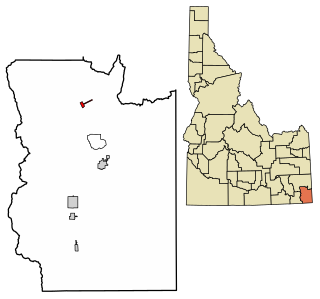
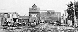
Georgetown is a city in the Bear River Valley in Bear Lake County, Idaho, United States, at the center of a farming area between the river and the mountains to the east. It was settled by Mormon pioneers on the route of the Oregon Trail and was named after George Q. Cannon. Georgetown was first settled in 1864 The population was 476 at the 2010 census. U.S. Route 30 passes through the town.

Lee, Illinois Village in Illinois, United States

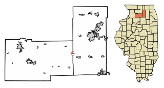
Lee is a village in DeKalb County and Lee County, Illinois, United States. The population was 337 at the 2010 census, up from 313 at the 2000 census.

Kanawha, Iowa City in Iowa, United States

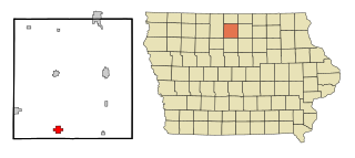
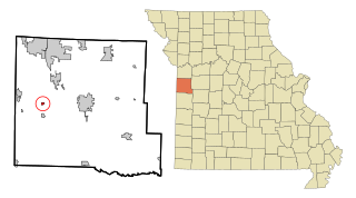
Kanawha is a city in Hancock County, Iowa, United States. The population was 658 at the time of the 2020 census.

New Liberty, Iowa City in Iowa, USA

New Liberty is a city in Scott County, Iowa, United States. The population was 138 at the time of the 2020 census.

Elsmore, Kansas City in Allen County, Kansas

Elsmore is a city in Allen County, Kansas, United States. As of the 2020 census, the population of the city was 50. The name Elsmore is a corruption of Elsinore, where Shakespeare's play Hamlet was set.

Georgetown, Louisiana Village in Louisiana, United States

Georgetown is a village in Grant Parish, Louisiana, United States. It is part of the Alexandria, Louisiana Metropolitan Statistical Area. The population was 327 at the 2010 census.

Lilydale, Minnesota City in Minnesota, United States

Lilydale is a city in Dakota County, Minnesota, United States. The population was 623 at the 2010 census.

Petersburg, Nebraska Village in Nebraska, United States

Petersburg is a village in Boone County, Nebraska, United States. The population was 333 at the 2010 census. Petersburg is the site of a memorial to Logan Fontenelle, an Omaha chief who was killed nearby, in a skirmish with Brulé and Arapaho in 1855, at the site of the present-day Olson Nature Preserve.

Hordville, Nebraska Village in Nebraska, United States

Hordville is a village in Hamilton County, Nebraska, United States. The population was 144 at the 2010 census.

Swanton, Nebraska Village in Nebraska, United States

Swanton is a village in Saline County, Nebraska, United States. The population was 94 at the 2010 census.

Lake Annette, Missouri City in Missouri, United States

Lake Annette is a city in Cass County, Missouri, United States. The population was 100 at the 2010 census. It is part of the Kansas City metropolitan area.

Clarkson Valley, Missouri City in Missouri, United States

Clarkson Valley is a city in St. Louis County, Missouri, United States. The population was 2,609 at the 2020 census.

New Paris, Ohio Village in Ohio, United States

New Paris is a village in Preble County, Ohio, United States. The population was 1,629 at the 2010 census. It is part of the Dayton Metropolitan Statistical Area.

Otis Orchards-East Farms, Washington CDP in Washington, United States

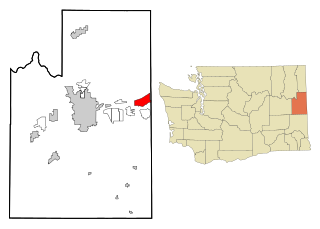
Otis Orchards-East Farms is a census-designated place (CDP) in Spokane County, Washington, United States, near the county's border with Idaho. The population was 6,220 at the 2010 census. The CDP includes the unincorporated communities of Otis Orchards and East Farms. Otis Orchards contains the bulk of the businesses of the community.

Pennsboro, West Virginia City in West Virginia, United States

Pennsboro is a city in Ritchie County, West Virginia, United States. The population was 1,050 at the 2020 census. The city is located at the junction of U.S. Route 50 and West Virginia Route 74; the North Bend Rail Trail also passes through the city.

Paden City, West Virginia City in West Virginia, United States

Paden City is a city in Tyler and Wetzel counties in the U.S. state of West Virginia, along the Ohio River. It was founded in 1902. The population was 2,550 at the 2020 census.

Lake Mills, Wisconsin City in Wisconsin, United States

Lake Mills is a city in Jefferson County, Wisconsin, United States. The population was 6,211 at the 2020 census. The city is located partially within the Town of Lake Mills.

References

  1. "2020 U.S. Gazetteer Files". United States Census Bureau. Retrieved July 24, 2022.
  2. 1 2 3 "Explore Census Data". United States Census Bureau . Retrieved April 20, 2022.
  3. 1 2 "City and Town Population Totals: 2020-2021". United States Census Bureau. June 8, 2022. Retrieved June 16, 2022.
  4. "US Board on Geographic Names". United States Geological Survey. October 25, 2007. Retrieved January 31, 2008.
  5. "US Gazetteer files 2010". United States Census Bureau. Archived from the original on January 25, 2012. Retrieved November 13, 2012.
  6. "NowData - NOAA Online Weather Data". National Oceanic and Atmospheric Administration. Retrieved September 25, 2021.
  7. "Station: Georgetown 1 E, MN". U.S. Climate Normals 2020: U.S. Monthly Climate Normals (1991-2020). National Oceanic and Atmospheric Administration. Retrieved September 25, 2021.
  8. Upham, Warren (1920). Minnesota Geographic Names: Their Origin and Historic Significance. Minnesota Historical Society. p.  116.
  9. "Clay County". Jim Forte Postal History. Archived from the original on April 27, 2015. Retrieved April 3, 2015.
  10. United States Census Bureau. "Census of Population and Housing" . Retrieved September 11, 2013.

Coordinates: 47°04′48″N96°47′39″W / 47.08000°N 96.79417°W / 47.08000; -96.79417